Felipe F Posted September 6, 2020 at 10:57 PM Share Posted September 6, 2020 at 10:57 PM Tufão está próximo de fazer landfall na Coreia do Sul. Rajadas de vento de até 150 km/h são possíveis na região. 1 Link to comment Share on other sites More sharing options...
Rodolfo Alves Posted September 6, 2020 at 11:10 PM Share Posted September 6, 2020 at 11:10 PM TV ESTATAL DA CORÉIA DO NORTE MAIS UMA VEZ ABRIU A TRANSMISSÃO EM HORÁRIO EXCEPCIONAL, POR VOLTA DAS 6:30, PARA ACOMPANHAR O AVANÇO DE HAISHEN. BOLETINS A CADA MEIA-HORA INTERCALADOS NA PROGRAMAÇÃO REGULAR ESTÃO SENDO EXIBIDOS, DIRETO DO "INMET" NORTE-COREANO E REPÓRTERS RELATANDO A SITUAÇÃO EM PONTOS DO PAÍS. 1 Link to comment Share on other sites More sharing options...
Rodolfo Alves Posted September 7, 2020 at 04:10 PM Share Posted September 7, 2020 at 04:10 PM TUFÃO HAISHEN JÁ SE ENCONTRA NA RÚSSIA. SEU ÚLTIMO AVISO FOI EXPEDIDO PELO JTWC. ACUMULADOS DE CHUVA FORAM ELEVADOS NA CORÉIA DO SUL: 141mm BUKGANGNEUNG 140mm TAEGWALLYYONG 132mm ULSAN 125mm SOSAN 123mm MASAN 117mm PUSAN NA CAPITAL SEUL, O ACUMULADO FICOU EM APENAS 28mm. RAJADAS DE VENTO DE 120km/h FORAM REGISTRADAS EM BUSAN (VALORES EM mph NO MAPA ABAIXO) NA VIZINHA CORÉIA DO NORTE TAMBÉM REGISTROU ALTOS VOLUMES DE CHUVA EM 24 HORAS: 207mm CHANGJON 153mm WOSAN 121mm CHONGJIN A ESTAÇÃO CONVENCIONAL DE CHANGJON REPORTOU VENTOS CONSTANTES DE 65km/h. EM UM DOS VÁRIOS PLANTÕES DA TV NORTE COREANA DURANTE A PROGRAMAÇÃO REGULAR DESSA SEGUNDA-FEIRA, MOSTROU-SE ALGUMAS CIDADES SIGNIFICANTEMENTE INUNDADAS E UMA REPÓRTER ENFRENTANDO FORTES VENTOS NA COSTA. NO VÍDEO É POSSÍVEL COLOCAR LEGENDAS EM INGLÊS OU PORTUGUÊS PARA A TRADUÇÃO. UMA CURIOSIDADE QUE FICOU EVIDENTE É QUE NA CORÉIA DO NORTE NÃO SE USA A NOMEAÇÃO INTERNACIONAL PARA OS TUFÕES. EM NENHUMA VEZ HOUVE A MENÇÃO DE "HAISHEN" OU "MAYSAK", COM A TELEVISÃO LOCAL E O PRÓPRIO CENTRO METEOROLÓGICO DO PAÍS CHAMANDO APENAS PELO NÚMERO, NO CASO DESTE O "TUFÃO Nº 10". 1 Link to comment Share on other sites More sharing options...
Miguel Russe Posted September 7, 2020 at 08:21 PM Author Share Posted September 7, 2020 at 08:21 PM Haishen se tornou uma baixa extratropical. Creio que nas reanalises possa ser atualizado para a categoria 5. 2 Link to comment Share on other sites More sharing options...
Rodolfo Alves Posted September 16, 2020 at 09:18 PM Share Posted September 16, 2020 at 09:18 PM TEMPESTADE TROPICAL NOUL SE FORMOU A OESTE DAS FILIPINAS. PODE VIRAR TUFÃO CATEGORIA 1 ANTES DE FAZER LANDFALL NO VIETNÃ NA SEXTA-FEIRA 1 Link to comment Share on other sites More sharing options...
mario junior Posted September 24, 2020 at 01:19 AM Share Posted September 24, 2020 at 01:19 AM (edited) STS Dolphin se formou perto do JPN. Teve pico de 65 mph pela JTWC e 70 mph pela JMA. Já é extratropical. STS Dolphin: Edited September 24, 2020 at 03:52 PM by mario junior 1 Link to comment Share on other sites More sharing options...
mario junior Posted September 26, 2020 at 02:07 PM Share Posted September 26, 2020 at 02:07 PM 97W próximo de ser 14W. Esperado para ser um forte tufão. TCFA JTWC WTPN21 PGTW 260900 MSGID/GENADMIN/JOINT TYPHOON WRNCEN PEARL HARBOR HI// SUBJ/TROPICAL CYCLONE FORMATION ALERT (INVEST 97W)// RMKS/ 1. FORMATION OF A SIGNIFICANT TROPICAL CYCLONE IS POSSIBLE WITHIN 210 NM EITHER SIDE OF A LINE FROM 18.3N 159.7E TO 25.1N 155.8E WITHIN THE NEXT 12 TO 24 HOURS. AVAILABLE DATA DOES NOT JUSTIFY ISSUANCE OF NUMBERED TROPICAL CYCLONE WARNINGS AT THIS TIME. WINDS IN THE AREA ARE ESTIMATED TO BE 15 TO 20 KNOTS. METSAT IMAGERY AT 260600Z INDICATES THAT A CIRCULATION CENTER IS LOCATED NEAR 19.2N 159.7E. THE SYSTEM IS MOVING NORTHWARD AT 08 KNOTS. 2. REMARKS: THE AREA OF CONVECTION (INVEST 97W) PREVIOUSLY LOCATED NEAR 18.9N 160.2E IS NOW LOCATED NEAR 19.2N 159.7E, APPROXIMATELY 391 NM WEST OF WAKE ISLAND. ANIMATED MULTISPECTRAL SATELLITE IMAGERY DEPICTS A BROAD LOW LEVEL CIRCULATION (LLC) WITH PERSISTENT CONVECTION IN THE SOUTHERN AND EASTERN SEMICIRCLES. A 260742Z SSMIS 91GHZ IMAGE REVEALS FORMATIVE BANDING IN THE SOUTHERN QUADRANT WRAPPING INTO THE EASTERN QUADRANT OF THE LLC. UPPER LEVEL ANALYSIS REVEALS A MARGINALLY FAVORABLE ENVIRONMENT WITH A POINT SOURCE OVER THE SYSTEM CENTER ENHANCING UPPER LEVEL DIFFLUENCE OFFSET BY AN UPPER LEVEL LOW HINDERING CONVECTION OVER THE NORTHWESTERN SEMICIRCLE. INVEST 97W IS EXPERIENCING LOW (<15KTS) VERTICAL WIND SHEAR AND WARM (30-31C) SEA SURFACE TEMPERATURES. GLOBAL MODELS ARE IN GOOD AGREEMENT THAT 97W WILL TRACK GENERALLY NORTH-NORTHWESTWARD WHILE CONTINUING TO SLOWLY CONSOLIDATE; HOWEVER, THE UPPER LEVEL LOW MAY HINDER CONVECTIVE DEVELOPMENT OVER THE WESTERN SEMICIRCLE. MAXIMUM SUSTAINED SURFACE WINDS ARE ESTIMATED AT 15 TO 20 KNOTS. MINIMUM SEA LEVEL PRESSURE IS ESTIMATED TO BE NEAR 1006 MB. THE POTENTIAL FOR THE DEVELOPMENT OF A SIGNIFICANT TROPICAL CYCLONE WITHIN THE NEXT 24 HOURS IS HIGH. 3. THIS ALERT WILL BE REISSUED, UPGRADED TO WARNING OR CANCELLED BY 270900Z.// NNNN JMA forecast TDIssued at 13:05 UTC, 26 September 2020 <Analysis at 12 UTC, 26 September> Scale - Intensity - TD Center position N18°50' (18.8°) E160°00' (160.0°) Direction and speed of movement NNW Slow Central pressure 1006 hPa Maximum wind speed near center 15 m/s (30 kt) Maximum wind gust speed 23 m/s (45 kt) <Forecast for 12 UTC, 27 September> Intensity - Center position of probability circle N23°05' (23.1°) E156°55' (156.9°) Direction and speed of movement NNW 25 km/h (13 kt) Central pressure 990 hPa Maximum wind speed near center 23 m/s (45 kt) Maximum wind gust speed 35 m/s (65 kt) Radius of probability circle 150 km (80 NM) <Forecast for 12 UTC, 28 September> Intensity - Center position of probability circle N27°20' (27.3°) E152°40' (152.7°) Direction and speed of movement NW 25 km/h (14 kt) Central pressure 975 hPa Maximum wind speed near center 30 m/s (60 kt) Maximum wind gust speed 45 m/s (85 kt) Radius of probability circle 165 km (90 NM) Storm warning area E 280 km (150 NM) W 220 km (120 NM) <Forecast for 12 UTC, 29 September> Intensity - Center position of probability circle N33°50' (33.8°) E153°20' (153.3°) Direction and speed of movement N 30 km/h (16 kt) Central pressure 950 hPa Maximum wind speed near center 40 m/s (80 kt) Maximum wind gust speed 60 m/s (115 kt) Radius of probability circle 260 km (140 NM) Storm warning area E 460 km (250 NM) W 360 km (195 NM) <Forecast for 12 UTC, 30 September> Intensity - LOW Center position of probability circle N41°50' (41.8°) E161°50' (161.8°) Direction and speed of movement NE 50 km/h (26 kt) Central pressure 986 hPa Maximum sustained wind speed 25 m/s (50 kt) Maximum wind gust speed 35 m/s (70 kt) Radius of probability circle 370 km (200 NM) 1 Link to comment Share on other sites More sharing options...
mario junior Posted September 29, 2020 at 03:26 PM Share Posted September 29, 2020 at 03:26 PM Kujira se intensificou a tufão de categoria 1 mínimo. Rajadas próximas de um categoria 2. Deve se tornar extra-tropical ainda hoje. WTPN31 PGTW 291500 MSGID/GENADMIN/JOINT TYPHOON WRNCEN PEARL HARBOR HI// SUBJ/TYPHOON 15W (KUJIRA) WARNING NR 012// RMKS/ 1. TYPHOON 15W (KUJIRA) WARNING NR 012 01 ACTIVE TROPICAL CYCLONE IN NORTHWESTPAC MAX SUSTAINED WINDS BASED ON ONE-MINUTE AVERAGE WIND RADII VALID OVER OPEN WATER ONLY --- WARNING POSITION: 291200Z --- NEAR 36.5N 156.4E MOVEMENT PAST SIX HOURS - 030 DEGREES AT 20 KTS POSITION ACCURATE TO WITHIN 030 NM POSITION BASED ON CENTER LOCATED BY SATELLITE PRESENT WIND DISTRIBUTION: MAX SUSTAINED WINDS - 065 KT, GUSTS 080 KT 1 Link to comment Share on other sites More sharing options...
Miguel Russe Posted October 25, 2020 at 12:49 AM Author Share Posted October 25, 2020 at 12:49 AM Após Kujira, tivemos: Chan-hom: JTWC: 90 MPH JMA: 80 MPH, 965 MBAR Linfa: JTWC: 50 MPH JMA: 45 MPH, 996 MBAR Nangka: JTWC: 60 MPH JMA: 50 MPH, 990 MBAR Ofel (94W): JMA: ≥35 MPH, 1002 MBAR Saudel: JTWC: 100 MPH JMA: 85 MPH, 965 MBAR MOLAVE ESTÁ (PROVAVELMENTE) EM UMA RÁPIDA INTENSIFICASÃO. JTWC E JMA CLASSIFICAM MOLAVE COMO UMA FRACA TS. 2 Link to comment Share on other sites More sharing options...
Tavares Posted October 25, 2020 at 01:41 AM Share Posted October 25, 2020 at 01:41 AM Eu adoro o esquema de cor do realce que o Windy usa no canal IR 2 Link to comment Share on other sites More sharing options...
Felipe F Posted October 27, 2020 at 03:40 AM Share Posted October 27, 2020 at 03:40 AM (edited) Molave pode ser um dos ciclones mais intensos a fazer landfall no Vietnã. Segundo a CNN 1,3 milhões estão sendo evacuados no Vietnã e 13 estão desaparecidos depois da passagem do tufão nas Filipinas. Edited October 27, 2020 at 03:42 AM by Felipe F 3 Link to comment Share on other sites More sharing options...
Sinforiana Miguel Gonzale Posted October 27, 2020 at 08:55 PM Share Posted October 27, 2020 at 08:55 PM Tufão Molave atingiu o pico de intensidade nesta manhã. Ventos máximos de 125 mph+ e 950 mbar. Destaque para o olho extremamente minúsculo, devido a forte convecção. Já está enfraquecendo e está próximo da categoria 2. Molave na pico de força: 2 1 Link to comment Share on other sites More sharing options...
Sinforiana Miguel Gonzale Posted October 27, 2020 at 08:57 PM Share Posted October 27, 2020 at 08:57 PM 3 Link to comment Share on other sites More sharing options...
Sinforiana Miguel Gonzale Posted October 28, 2020 at 07:00 PM Share Posted October 28, 2020 at 07:00 PM HWRF prevendo que Gobi será um tufão da categoria 4. 2 Link to comment Share on other sites More sharing options...
Miguel Russe Posted October 29, 2020 at 02:57 AM Author Share Posted October 29, 2020 at 02:57 AM 6 horas atrás, Sinforiana Miguel Gonzale disse: HWRF prevendo que Goni será um tufão da categoria 4. JTWC prevendo algo mais forte do que isso: 120 KNOTS 1 Link to comment Share on other sites More sharing options...
Miguel Russe Posted October 29, 2020 at 04:12 AM Author Share Posted October 29, 2020 at 04:12 AM (edited) HWRF - 1800Z - 90W (#ATSANI) - 140.5 KNOTS - 908 MBAR nem vou dormir com essa rodada do HWRF Edited October 29, 2020 at 04:20 AM by Miguel Russe Troquei o gif de baixo por outro melhor 3 Link to comment Share on other sites More sharing options...
Felipe F Posted October 29, 2020 at 06:27 PM Share Posted October 29, 2020 at 06:27 PM Tufão Goni 1 Link to comment Share on other sites More sharing options...
Felipe F Posted October 29, 2020 at 06:31 PM Share Posted October 29, 2020 at 06:31 PM Tufão Molave fez landfall no Vietnã entre categoria 1/2. Até o momento 47 mortos e quase 100 desaparecidos. 1 2 Link to comment Share on other sites More sharing options...
Felipe F Posted October 29, 2020 at 06:33 PM Share Posted October 29, 2020 at 06:33 PM Ciclone ATSANI também se formou no Pacifico. Previsto para ser outro poderoso tufão. 1 Link to comment Share on other sites More sharing options...
Sinforiana Miguel Gonzale Posted October 29, 2020 at 07:54 PM Share Posted October 29, 2020 at 07:54 PM 22W GONI 201029 1800 16.3N 133.4E WPAC 120 943 2 Link to comment Share on other sites More sharing options...
Miguel Russe Posted October 29, 2020 at 10:20 PM Author Share Posted October 29, 2020 at 10:20 PM 1 hora atrás, Sinforiana Miguel Gonzale disse: 22W GONI 201029 1800 16.3N 133.4E WPAC 120 943 JTWC prevendo categoria 5 para amanhã entre a tarde e noite: 2 Link to comment Share on other sites More sharing options...
Felipe F Posted October 29, 2020 at 10:43 PM Share Posted October 29, 2020 at 10:43 PM Goni - categoria 4 1 Link to comment Share on other sites More sharing options...
Felipe F Posted October 29, 2020 at 10:52 PM Share Posted October 29, 2020 at 10:52 PM Parede do olho bem estruturada. 3 Link to comment Share on other sites More sharing options...
Sinforiana Miguel Gonzale Posted October 30, 2020 at 12:58 AM Share Posted October 30, 2020 at 12:58 AM Goni deve estar no limite da categoria 4: 2 Link to comment Share on other sites More sharing options...
Miguel Russe Posted October 30, 2020 at 03:29 AM Author Share Posted October 30, 2020 at 03:29 AM Link to comment Share on other sites More sharing options...
Miguel Russe Posted October 30, 2020 at 09:57 AM Author Share Posted October 30, 2020 at 09:57 AM Wow! WTPN31 PGTW 300900 MSGID/GENADMIN/JOINT TYPHOON WRNCEN PEARL HARBOR HI// SUBJ/SUPER TYPHOON 22W (GONI) WARNING NR 010// RMKS/ 1. SUPER TYPHOON 22W (GONI) WARNING NR 010 02 ACTIVE TROPICAL CYCLONES IN NORTHWESTPAC MAX SUSTAINED WINDS BASED ON ONE-MINUTE AVERAGE WIND RADII VALID OVER OPEN WATER ONLY --- WARNING POSITION: 300600Z --- NEAR 16.3N 131.6E MOVEMENT PAST SIX HOURS - 265 DEGREES AT 11 KTS POSITION ACCURATE TO WITHIN 010 NM POSITION BASED ON EYE FIXED BY SATELLITE PRESENT WIND DISTRIBUTION: MAX SUSTAINED WINDS - 150 KT, GUSTS 180 KT WIND RADII VALID OVER OPEN WATER ONLY RADIUS OF 064 KT WINDS - 010 NM NORTHEAST QUADRANT 010 NM SOUTHEAST QUADRANT 010 NM SOUTHWEST QUADRANT 015 NM NORTHWEST QUADRANT RADIUS OF 050 KT WINDS - 025 NM NORTHEAST QUADRANT 030 NM SOUTHEAST QUADRANT 025 NM SOUTHWEST QUADRANT 035 NM NORTHWEST QUADRANT RADIUS OF 034 KT WINDS - 055 NM NORTHEAST QUADRANT 045 NM SOUTHEAST QUADRANT 035 NM SOUTHWEST QUADRANT 055 NM NORTHWEST QUADRANT REPEAT POSIT: 16.3N 131.6E 2 Link to comment Share on other sites More sharing options...
Felipe F Posted October 30, 2020 at 02:01 PM Share Posted October 30, 2020 at 02:01 PM Goni oficialmente na categoria 5. Ventos sustentados em 285 km/h e pressão 905 mbar. 2 Link to comment Share on other sites More sharing options...
Felipe F Posted October 30, 2020 at 02:04 PM Share Posted October 30, 2020 at 02:04 PM Super Tufão Goni 2 Link to comment Share on other sites More sharing options...
Felipe F Posted October 30, 2020 at 02:05 PM Share Posted October 30, 2020 at 02:05 PM 2 Link to comment Share on other sites More sharing options...
Tavares Posted October 30, 2020 at 03:04 PM Share Posted October 30, 2020 at 03:04 PM 46 minutos atrás, Felipe F disse: Isso é muito poder! Na segunda metade do loop o olho tá completamente limpo, sem aqueles mesovórtices que 'poluem' a observação. A foto do Dorian mal dava pra ver o olho com o Sol a pino. Aliás eu achava que o nome Goni tinha sido retirado. 1 Link to comment Share on other sites More sharing options...
Miguel Russe Posted October 30, 2020 at 03:16 PM Author Share Posted October 30, 2020 at 03:16 PM Goni segue ganhando força: WTPN31 PGTW 301500 MSGID/GENADMIN/JOINT TYPHOON WRNCEN PEARL HARBOR HI// SUBJ/SUPER TYPHOON 22W (GONI) WARNING NR 011// RMKS/ 1. SUPER TYPHOON 22W (GONI) WARNING NR 011 02 ACTIVE TROPICAL CYCLONES IN NORTHWESTPAC MAX SUSTAINED WINDS BASED ON ONE-MINUTE AVERAGE WIND RADII VALID OVER OPEN WATER ONLY --- WARNING POSITION: 301200Z --- NEAR 16.1N 130.9E MOVEMENT PAST SIX HOURS - 255 DEGREES AT 07 KTS POSITION ACCURATE TO WITHIN 010 NM POSITION BASED ON EYE FIXED BY SATELLITE PRESENT WIND DISTRIBUTION: MAX SUSTAINED WINDS - 155 KT, GUSTS 190 KT WIND RADII VALID OVER OPEN WATER ONLY RADIUS OF 064 KT WINDS - 025 NM NORTHEAST QUADRANT 015 NM SOUTHEAST QUADRANT 015 NM SOUTHWEST QUADRANT 020 NM NORTHWEST QUADRANT RADIUS OF 050 KT WINDS - 045 NM NORTHEAST QUADRANT 030 NM SOUTHEAST QUADRANT 025 NM SOUTHWEST QUADRANT 040 NM NORTHWEST QUADRANT RADIUS OF 034 KT WINDS - 085 NM NORTHEAST QUADRANT 065 NM SOUTHEAST QUADRANT 060 NM SOUTHWEST QUADRANT 080 NM NORTHWEST QUADRANT REPEAT POSIT: 16.1N 130.9E 1 Link to comment Share on other sites More sharing options...
Miguel Russe Posted October 30, 2020 at 03:24 PM Author Share Posted October 30, 2020 at 03:24 PM JMA coloca Goni com 115 kt e 915 mbar. Oficialmente, Goni é o mais poderoso ciclone da bacia do Pacífico Oeste, ultrapassando o (subestimado) Haishen, e o mais poderoso do mundo até agora, Ultrapassando Amphan, Harold e Haishen. TY 2019 (Goni)Issued at 12:45 UTC, 30 October 2020 <Analysis at 12 UTC, 30 October> Scale - Intensity Violent Center position N16°05' (16.1°) E130°55' (130.9°) Direction and speed of movement WSW 15 km/h (7 kt) Central pressure 915 hPa Maximum wind speed near center 60 m/s (115 kt) Maximum wind gust speed 85 m/s (165 kt) ≥ 50 kt wind area ALL 95 km (50 NM) ≥ 30 kt wind area ALL 280 km (150 NM) 2 Link to comment Share on other sites More sharing options...
Miguel Russe Posted October 30, 2020 at 03:40 PM Author Share Posted October 30, 2020 at 03:40 PM Agora, Tavares disse: Isso é muito poder! Na segunda metade do loop o olho tá completamente limpo, sem aqueles mesovórtices que 'poluem' a observação. A foto do Dorian mal dava pra ver o olho com o Sol a pino. Aliás eu achava que o nome Goni tinha sido retirado. Vê só: 4 Link to comment Share on other sites More sharing options...
Miguel Russe Posted October 30, 2020 at 05:04 PM Author Share Posted October 30, 2020 at 05:04 PM 3 Link to comment Share on other sites More sharing options...
Felipe F Posted October 30, 2020 at 06:01 PM Share Posted October 30, 2020 at 06:01 PM 2 horas atrás, Tavares disse: Aliás eu achava que o nome Goni tinha sido retirado. Japão não solicitou a retirada do nome em 2015, mesmo com 74 mortos e estimativa de 1 bilhão de dólares em danos. No Indico tem um ciclone com nome bem parecido ( Gonu), que foi retirado em 2007. 1 Link to comment Share on other sites More sharing options...
Tavares Posted October 30, 2020 at 06:22 PM Share Posted October 30, 2020 at 06:22 PM Pesado! Dois tufões vão atingir a Ilha de Luzon nas Filipinas nos próximos dias com forte intensidade, de acordo com o ECMWF. Ambos também devem afetar o Vietnam que, salvo engano, enfrentou 5 (CINCO!) sistemas tropicais em Outubro Acumulação de rajadas nos próximos 10 dias Acumulação de chuvas nos próximos 10 dias 3 1 1 Link to comment Share on other sites More sharing options...
Miguel Russe Posted October 30, 2020 at 06:24 PM Author Share Posted October 30, 2020 at 06:24 PM Agora, Felipe F disse: No Indico tem um ciclone com nome bem parecido ( Gonu), que foi retirado em 2007 No indico norte todos os nomes se usam só uma vez. Amphan foi usado esse ano se for usado novamente sera daqui uns 100 ou 200 anos. Não foi atoa que o IMD desperdiçou nomes tão legais para ciclones b*ndas e criar uma lista imensa cheia de nomes esquisitos Link to comment Share on other sites More sharing options...
Miguel Russe Posted October 30, 2020 at 06:27 PM Author Share Posted October 30, 2020 at 06:27 PM (edited) Agora, Tavares disse: Pesado! Será que sobe para 160 kt? Será que pode chegar a pressão sub-905 mbar pela JMA? Será que atinge as filipinas bem mais fraco? São perguntas que eu quero que se "cumpram" Edited October 30, 2020 at 06:31 PM by Miguel Russe 1 Link to comment Share on other sites More sharing options...
Renan Posted October 30, 2020 at 06:31 PM Share Posted October 30, 2020 at 06:31 PM Que ciclone maravilhoso ! O mais bonito do ano até agora. 2 Link to comment Share on other sites More sharing options...
Felipe F Posted October 30, 2020 at 06:43 PM Share Posted October 30, 2020 at 06:43 PM 3 1 Link to comment Share on other sites More sharing options...
Miguel Russe Posted October 30, 2020 at 06:43 PM Author Share Posted October 30, 2020 at 06:43 PM Goni esteve sujeito a um ERC marginal após o anoitecer, mas já o ciclo já está completo. Goni deixou de ser aquele pequeno categoria 5 e ganhou agora um aspecto que o deixa com mais cara de ser um Potentially Catastrophic categoria 5. E como dito pelo @Renan, Goni é um ciclone muito impressionante. Esse novo aspecto combinou com a intensidade dele. 2 Link to comment Share on other sites More sharing options...
Miguel Russe Posted October 30, 2020 at 06:50 PM Author Share Posted October 30, 2020 at 06:50 PM Destaque vai para Linfa, que causou cerca de 500 milhões de dólares e matou quase 200 pessoas Agora, Tavares disse: o Vietnam que, salvo engano, enfrentou 5 (CINCO!) sistemas tropicais em Outubro Link to comment Share on other sites More sharing options...
Miguel Russe Posted October 30, 2020 at 10:25 PM Author Share Posted October 30, 2020 at 10:25 PM Magandang umaga, bagyong Rolly (Goni)! Bom dia, tufão Rolly (Goni)! 3 Link to comment Share on other sites More sharing options...
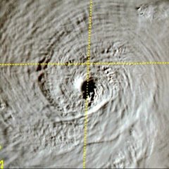
Sinforiana Miguel Gonzale Posted October 31, 2020 at 01:59 AM Share Posted October 31, 2020 at 01:59 AM 22W GONI 201031 0000 15.3N 128.8E WPAC 160 895 3 Link to comment Share on other sites More sharing options...
Felipe F Posted October 31, 2020 at 02:24 PM Share Posted October 31, 2020 at 02:24 PM Super Tufão Goni segue aproximando das Filipinas como um poderoso categoria 5. Até o momento não teve ciclo de substituição da parede do olho (parecido com que Hyaian fez em 2013). Link to comment Share on other sites More sharing options...
Felipe F Posted October 31, 2020 at 02:27 PM Share Posted October 31, 2020 at 02:27 PM Goni 1 1 Link to comment Share on other sites More sharing options...
Felipe F Posted October 31, 2020 at 03:10 PM Share Posted October 31, 2020 at 03:10 PM Ciclone segue ganhando força e aproximando de T8.0 . 2 Link to comment Share on other sites More sharing options...
PabloMartins Posted October 31, 2020 at 03:13 PM Share Posted October 31, 2020 at 03:13 PM 49 minutos atrás, Felipe F disse: Super Tufão Goni segue aproximando das Filipinas como um poderoso categoria 5. Até o momento não teve ciclo de substituição da parede do olho (parecido com que Hyaian fez em 2013). na verdade teve, mas as condições atmosféricas e oceânicas estão tão boas que ele só sentiu cócegas, estamos diante de um parente de Haiyan, MUITO semelhante. 1 Link to comment Share on other sites More sharing options...
Felipe F Posted October 31, 2020 at 03:14 PM Share Posted October 31, 2020 at 03:14 PM Super Tufão Goni 3 Link to comment Share on other sites More sharing options...
Felipe F Posted October 31, 2020 at 03:23 PM Share Posted October 31, 2020 at 03:23 PM 1 minuto atrás, PabloMartins disse: na verdade teve, mas as condições atmosféricas e oceânicas estão tão boas que ele só sentiu cócegas, estamos diante de um parente de Haiyan, MUITO semelhante. Sim, estava vendo as imagens depois, além de comentários em fóruns e foi um ciclo de substituição onde houve uma fusão da antiga parede do olho com a nova. Da até para ver nas imagens a oscilação nos olhos. 3 Link to comment Share on other sites More sharing options...
Recommended Posts