Jump to content
Brasil Abaixo de Zero

Felipe F

Advisors
  • Posts

    13033
  • Joined

  • Last visited

  • Days Won

    149

Everything posted by Felipe F
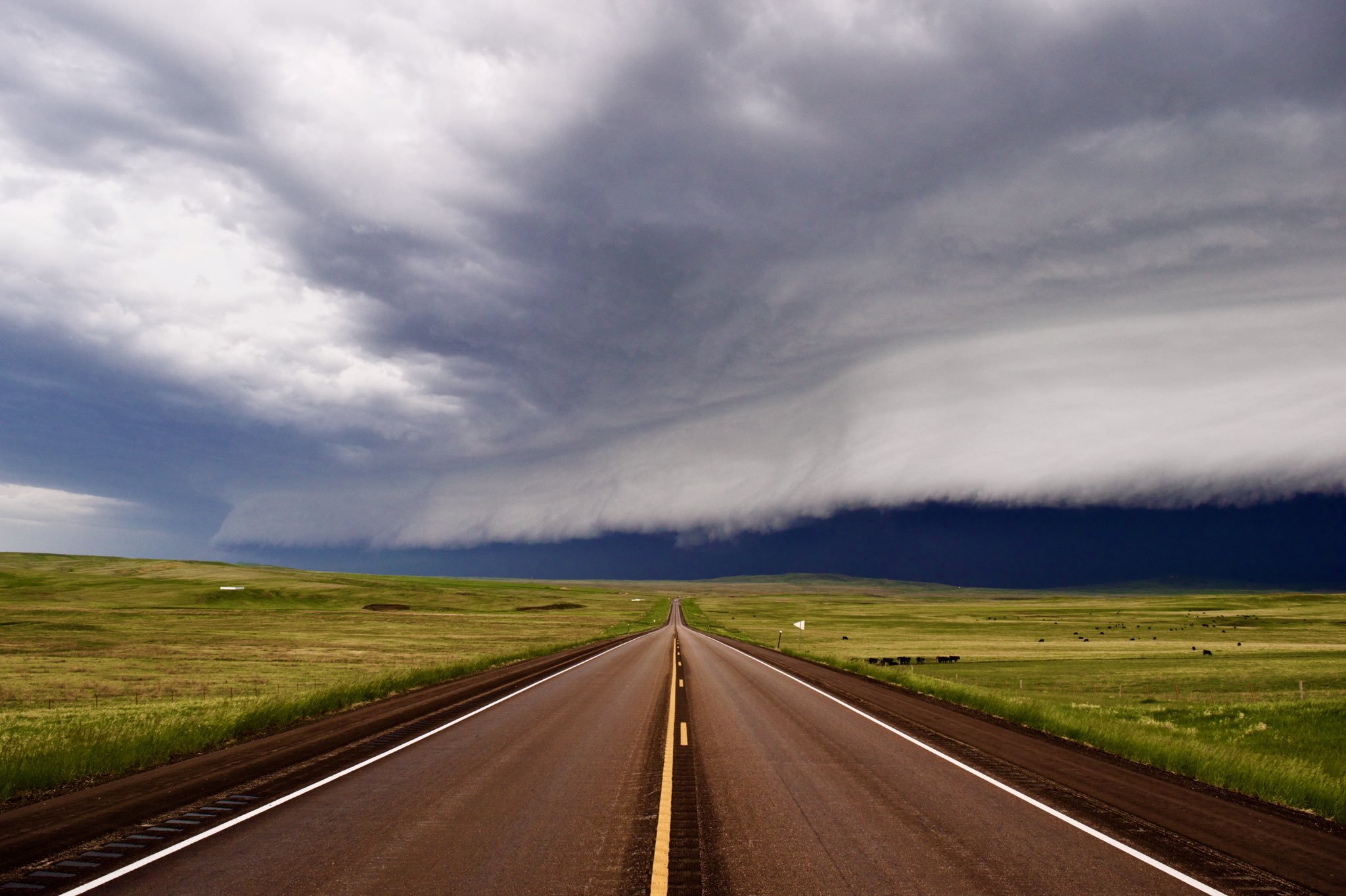
  1. Patrocínio teve máxima de 20,4ºC hoje, sendo a menor do ano até o momento. Nenhum modelo acertou hoje, todos erraram por 4ºC. Neste momento chove fraco e faz 18ºC. Destaque também para as fortes chuvas registradas em cidades do Alto Paranaíba agora em Maio. Serra do Salitre por exemplo já acumula 150 mm, sendo 73 mm somente ontem. (Média 45 mm) A máxima na cidade hoje foi de 17,6ºC.
  2. Isso não vale para boa parte do país. Como pode ser visto pelos dados, agosto ser mais frio que maio é algo mais restrito ao RS, SC (mais subtropicais) e litorais do Sudeste/PR (devido ao oceano mais frio em Agosto). Na maioria dos locais, ambos possuem a mesma média, com Agosto já apresentando máximas elevadas. Exemplos (média 61/90): Mineiros, GO - Maio: 21,1ºC / Agosto: 21,8ºC Jataí, GO - Maio: 20,5ºC /Agosto: 20,4ºC Araxá, MG - Maio: 18,7ºC / Agosto: 19,4ºC BH - Maio: 19,6ºC / Agosto: 19,7ºC Lavras, MG - Maio: 17,4ºC / Agosto: 17,7ºC Juiz de Fora, MG - Maio: 17,6ºC / Agosto: 17,2ºC Dourados, MS - Maio: 19,8ºC / Agosto: 19,6ºC Ponta Porã, MS - Maio: 18,4ºC / Agosto: 18,1ºC Campo Grande, MS - Maio: 20,8ºC / Agosto: 21,4ºC Campo Mourão, PR - Maio: 17,7ºC / Agosto: 17,5ºC Curitiba, PR - Maio: 14,5ºC / Agosto: 14,1ºC Londrina, PR - Maio: 18,3ºC / Agosto: 18,4ºC Rio - Maio: 22,8ºC / Agosto: 21,8ºC Araçatuba, SP - Maio: 20,2ºC / Agosto: 21,1ºC SP (MIRANTE) - Maio: 17,4ºC / Agosto: 17,1ºC Iguape, SP - Maio: 20,1ºC / Agosto: 18,6ºC Floripa - Maio: 18,9ºC / Agosto: 16,9ºC Xanxerê, SC - Maio: 15,1ºC / Agosto: 14,7ºC Lages, SC - Maio: 12,9ºC / Agosto: 11,9ºC Bagé, RS - Maio: 15,0ºC / Agosto: 13,1ºC POA, RS - Maio: 16,9ºC / Agosto: 15,2ºC Passo Fundo, RS: 15,2ºC / Agosto: 13,9ºC
  3. Patrocínio registrou 38,6 mm ontem (15), com a primeira chuva ocorrendo durante a madrugada e a segunda no final da noite. A média do mês já está em 44 mm, acima da média da normal 07/18 de 35 mm.
  4. Ar frio entrou ontem em áreas do sul de Goiás e oeste/sul do Triângulo Mineiro. Ituiutaba e Campina Verde que tiveram mínimas ao redor de 21ºC ontem (considerando só a madrugada), hoje tiveram 14ºC. Esses valores são ridículos ainda, mas pelo menos temos algum sinal de mudança!
  5. Semana será animada!! Essa é a primeira vez que o SPC emite uma previsão com chance de tempo severo para todos os dias após dia 3.
  6. SPC menciona até o dia 9. ...DISCUSSION... On Thursday/D4, an upper ridge will be in place across the central U.S. with a large upper trough across the West. Meanwhile, northwest flow will exist across the Great Lakes with a low amplitude wave moving quickly from northern MN toward PA by Friday/D5 morning. A cold front will accompany this wave, with lift focused from MN into IA, northern IL/IN and OH. Substantial westerly winds at 850 mb will transport theta-e across IA and IL toward the front, with a corridor of strong to possibly severe thunderstorms from IA across southern WI and northern IL during the late afternoon and evening. Damaging winds would be most likely. A this time predictability is too low to denote an MCS corridor, but a Slight Risk is possible in later updates. Also on Thursday/D4, moisture and instability will spread west across NE and southern SD, as the leading height falls with the western trough approach the High Plains. Isolated severe hail and wind is possible over parts of eastern WY, western NE, and southwest SD during the late afternoon and evening. On Friday/D5, strong southwest flow aloft will spread into the Plains, with the strongest winds from NM into west TX. Low pressure is forecast across northeast CO into NE during the day, with a dryline extending southward into west TX. Widespread mid 60s F dewpoints will be in place ahead of the dryline, and northward to the warm front from eastern SD into IA. Moderate to strong instability will develop over the warm sector, with wind profiles supporting supercells producing very large hail and a few tornadoes. Clusters of storms, or an MCS, is also possible overnight mainly over northwest TX into western OK. For Saturday/D6, significant differences exist regarding the shortwave trough, with the new ECMWF showing a compact, negative-tilt shortwave from northwest TX across OK and into KS. Meanwhile, the GFS based members show a less amplified solution, with the main threat area farther east. Either solution will support severe weather, whether more of a squall line producing damaging winds, or a mixed mode threat including supercells and tornadoes. As such, have introduced 15% severe probs for Saturday, mainly across OK and TX. For Sunday/D7, a moist, unstable air mass is most likely to exist over eastern TX and into AR and possibly MO. Much of this area will be behind the departing upper trough, thus predictability is quite low. On Monday/D8, models show a broad area of cyclonic flow aloft again across the West, with some manner of trough amplification possible into the Plains. Predictability is low, however, substantial low-level moisture will be available for any wave that emerges into the Plains, including into Tuesday/D9, with bouts of severe weather possible from the Plains to the Midwest. ..Jewell.. 05/13/2019
  7. Modelos seguem agressivos para final de semana e a próxima. Sexta (17) e Sábado (18).
  8. Maio deve seguir o padrão de Março/Abril e terminar acima da média baseado nos dados atuais. 2019 está sendo um ano bem ativo, porém como em 2018 com poucos tornados sendo fortes/violentos.
  9. Em Floripa as anomalias estão assim no INMET (automática): Máximas: +2,5ºC Mínimas: +5,2ºC
  10. A primeira quinzena de Maio deve terminar quase +3,0ºC acima da média em Patrocínio. Na quarta pode ocorrer uma mudança na região, o que ajudaria a reduzir a anomalia das máximas que está em +2,0°C. Já as mínimas devem seguir acima da média, com a anomalia se mantendo próximo dos +3,5ºC atuais.
  11. Tempo severo volta na sexta (17). Reed para variar está empolgado.
  12. Caos em Houston, TX no momento. Chuva intensa e granizo grande sobre a cidade.
  13. Acumulados de neve de quase 25 cm hoje em cidades do MN. O acumulado em Duluth e o maior já registrado em Maio. (Valor atual em 9,1")
  14. SPC alertando que existe um risco de tornado forte na Louisiana.
  15. Uma linha de instabilidade se formou no Texas e avança para a Louisiana no momento. Dois tornado foram reportados no Texas. Alguns TORNADO WARNING estão em vigor neste momento.
  16. 18 tornados foram reportados ontem. Houve alguns danos, mas nada mais grave foi reportado até o momento.
×
×
  • Create New...

Important Information

By using this site, you agree to our Guidelines.