
IgorTFreitas
-
Posts
232 -
Joined
-
Last visited
Content Type
Profiles
Forums
Gallery
Calendar
Posts posted by IgorTFreitas
-
-
Por aqui mínima de 15.9ºC, no momento faz 26.6ºC, bate uma tristeza ver uma previsão dessa pros próximos dias

-
 9
9
-
 5
5
-
-
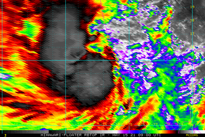
Tauktae em 6.4 na escala dvorak
-
1
-
-
-
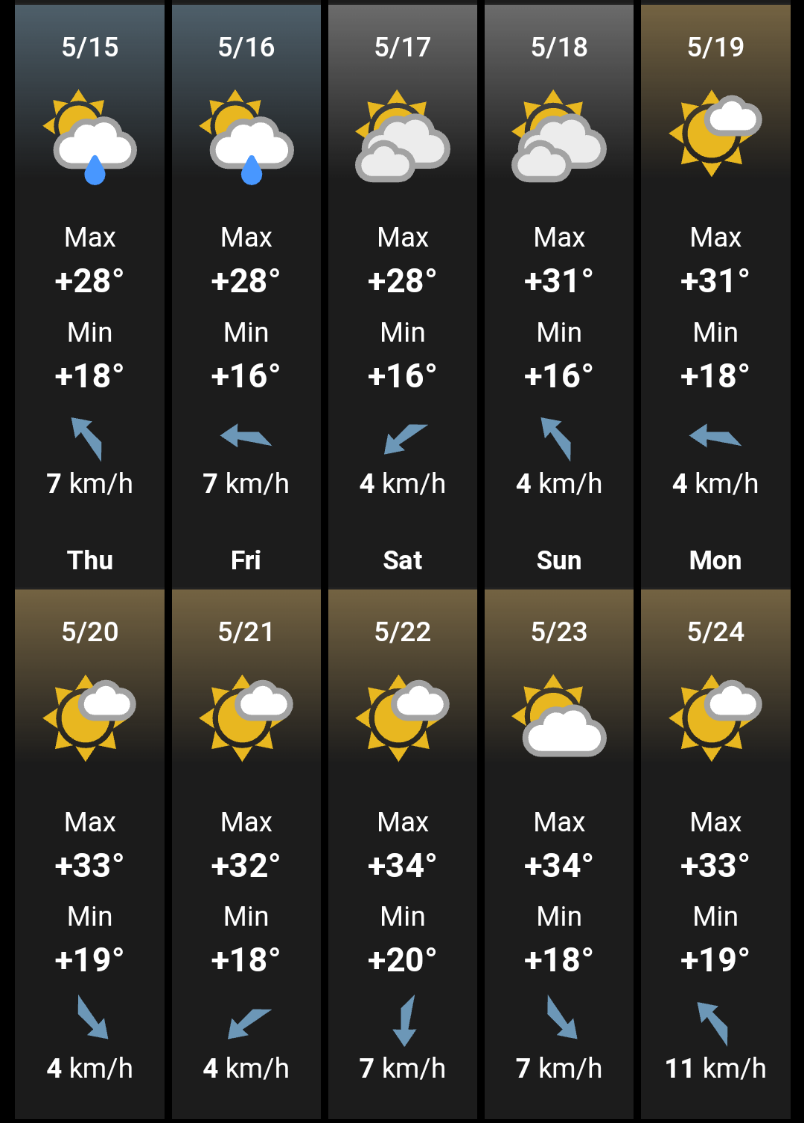
Bom dia, por aqui tivemos mínima de 17°C, no momento faz 22.4°C - 77% UR com céu nublado, pros próximos dias alguns sites resolveram colocar forte calor pra cá com máximas podendo chegar aos 34°C ( espero que seja só mais uma loucura do modelo e que não faça esse calor todo )
-
11
-
 1
1
-
1
-
-
-
AHHHH,o fim da grade🥺🤡
-
7
-
 2
2
-
-
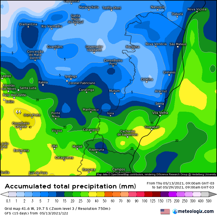
Quase 1 mês sem uma boa chuva, apenas valores de 2.5mm ou menos e bem localizado
GFS pros próximos 15 dias não está nada animador, apenas pro sul do ES acumulados de chuva melhores
-
9
-
2
-
-
E O LA NIÑA CHEGA AO SEU FIM, 67% DE CHANCE DE NEUTRALIDADE DURANTE O VERÃO NO HEMISFÉRIO NORTE
EL NIÑO/SOUTHERN OSCILLATION (ENSO) DIAGNOSTIC DISCUSSION issued by
CLIMATE PREDICTION CENTER/NCEP/NWS
and the International Research Institute for Climate and Society13 May 2021 ENSO Alert System Status: Final La Niña Advisory
Synopsis: La Niña has ended, with ENSO-neutral likely to continue through the Northern Hemisphere summer (67% chance in June-August 2021).
During April, the tropical Pacific Ocean returned to ENSO-neutral conditions as the coupling between the atmosphere and ocean weakened. Sea surface temperatures were near-to-below average across most of the equatorial Pacific Ocean in the past month [Fig. 1]. The Niño indices have generally trended toward normal during the last several months, except for the easternmost Niño-1+2 region, which was -0.7°C in the past week [Fig. 2]. Subsurface temperature anomalies continued to increase [Fig. 3] due to a downwelling Kelvin wave, which reinforced the positive temperature anomalies along the thermocline [Fig. 4]. Low-level easterly wind anomalies were weakly present in the east-central Pacific, but were westerly in the far western Pacific Ocean, while upper-level wind anomalies remained westerly across the central and east-central tropical Pacific. Tropical convection became near average around the Date Line in the past month, with suppressed convection evident over Indonesia [Fig. 5]. Overall, the ocean and atmosphere system reflected a return to ENSO-neutral.
Most of the models in the IRI/CPC plume predict a continuation of ENSO-neutral through the Northern Hemisphere summer 2021 [Fig. 6]. The forecaster consensus agrees with this set of models through the summer, and then begins hedging toward cooler conditions as the Northern Hemisphere fall approaches. La Niña chances are around 50-55% during the late fall and winter, which is in alignment with forecasts from the NCEP Climate Forecast System and North American Multi-model Ensemble. However, there is typically large uncertainty with forecasts made in the spring, so confidence in ENSO-neutral for the coming seasons is highest. In summary, La Niña has ended, with ENSO-neutral likely to continue through the Northern Hemisphere summer (67% chance in June-August 2021; click CPC/IRI consensus forecast for the chances in each 3-month period).
This discussion is a consolidated effort of the National Oceanic and Atmospheric Administration (NOAA), NOAA's National Weather Service, and their funded institutions. Oceanic and atmospheric conditions are updated weekly on the Climate Prediction Center web site (El Niño/La Niña Current Conditions and Expert Discussions). Additional perspectives and analysis are also available in an ENSO blog. A probabilistic strength forecast is available here. The next ENSO Diagnostics Discussion is scheduled for 10 June 2021.
-
1
-
2
-
-
MÍNIMAS ABAIXO DE 15ºC NO AMANHECER DE 11/05 NO ES:
Venda Nova do Imigrante* : 9.3ºC
Alfredo Chaves* : 15.1ºC
Alegre* : 13.1ºC
Santa Teresa* : 12.4ºC
Marilândia* : 14.6ºC
Nova Venécia* : 14.7ºC
Alto Rio Novo** : 12.0ºC
Venda Nova do Imigrante** : 10.3ºC
Muniz Freire** : 9.1ºC
Afonso Cláudio** : 8.3ºC
*INMET
**PARTICULAR
Infelizmente a estação de Marilândia não está funcionando corretamente e provavelmente a mínima foi menor ainda
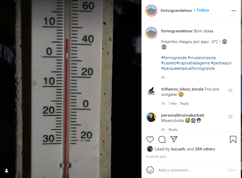
INTERIOR DE CASTELO COM 6ºC
-
14
-
4
-
-
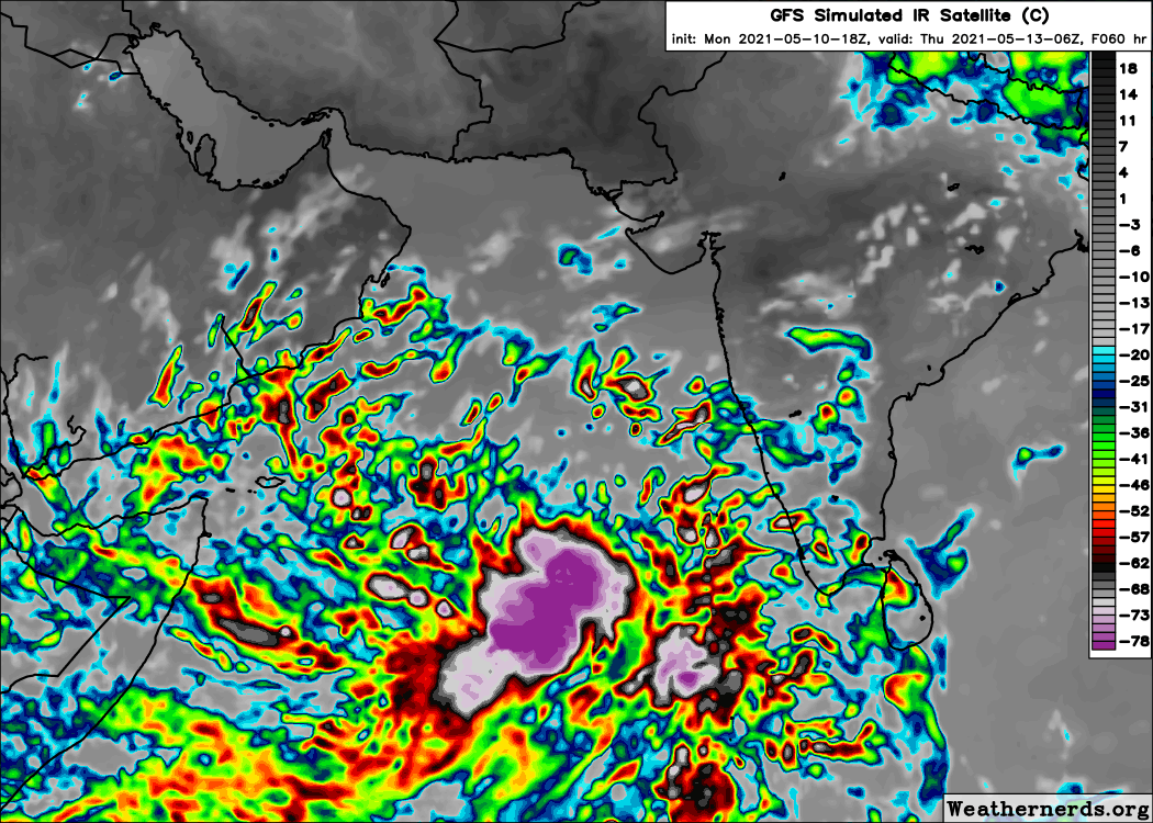
JTWC Boletim:
(1) AN AREA OF CONVECTION (INVEST 92A) HAS PERSISTED NEAR 8.0N
57.5E, APPROXIMATELY 320 NM SOUTH-SOUTHEAST OF SOCOTRA, YEMEN.
ANIMATED ENHANCED INFRARED (EIR) SATELLITE IMAGERY AND A PARTIAL
102151Z AMSR2 89 GHZ MICROWAVE IMAGE REVEALS DISORGANIZED BANDING
WITH CYCLING CONVECTION WRAPPING INTO A RELATIVELY WEAK LOW LEVEL
CIRCULATION (LLC). A 101730Z ASCAT-B PASS INDICATES AN ELONGATED
CIRCULATION WITH 25-30KT WINDS ALONG THE NORTHERN AND SOUTHERN
PERIPHERIES. ENVIRONMENTAL ANALYSIS INDICATE INVEST 92A IS IN AN
AREA OF FAVORABLE TROPICAL DEVELOPMENT WITH GOOD POLEWARD OUTFLOW
ALOFT, LOW (10-15KT) VERTICAL WIND SHEER AND VERY WARM (30-31C) SEA
SURFACE TEMPERATURE. GLOBAL MODELS ARE IN GOOD AGREEMENT THAT INVEST
92A WILL CONSOLIDATE AND INTENSIFY AS IT TRACKS EASTWARD OVER
THE NEXT 24-48 HOURS. MAXIMUM SUSTAINED SURFACE WINDS ARE ESTIMATED
AT 23 TO 28 KNOTS. MINIMUM SEA LEVEL PRESSURE IS ESTIMATED TO BE
NEAR 1003 MB. THE POTENTIAL FOR THE DEVELOPMENT OF A SIGNIFICANT
TROPICAL CYCLONE WITHIN THE NEXT 24 HOURS IS MEDIUM.
-
1
-
-
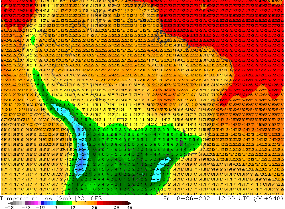
Última rodada do GFS ( 18Z ) prevendo incríveis 900mb de pressão
-
3
-
-
Tchau Tempestade Tropical ANDRES
-
1 hour ago, Bruno D said:
Dia 03/07: O poderoso Anticiclone agora se encontra, sobre o Leste de SP, Sul de MG e o RJ, com mais de 1036hpa em seu centro. Mínimas extraordinárias são registradas sobre todo o Sudeste Brasileiro, e até mesmo cidades litorâneas de SP e RJ registram geadas. Ao final do dia meteorológico a Alta se dirige ao Mar, entre a dívida de ES e RJ, com poderosos 1038hpa em seu centro, se fundindo com outro Anticiclone ao Sul (Reforço) dando origem a um episódio de Asas, que prolonga o frio por mais 7-10 dias em todo o Sudeste, e Leste do PR e SC.
Quanto de frio será que faria aqui em Governador Lindenberg/ES em um evento desses? Na estação do INMET de Marilândia ( municipio bem próximo daqui ) a menor temperatura já registrada foi de 6,7 ºC em 22 de junho de 1976. Será que baixaria dos 5ºC com geada fraca ou até moderada?
-
9
-
-
5 hours ago, SandroAlex said:
Queridos! Postei as projeções abaixo porque as datas coincidiram com as da MP de 2013 e me fizeram viajar no tempo... tive lembranças daquele espetáculo que a natureza proporcionou..
Tem essas pra junho também...
-
7
-
5
-
-
1 hour ago, IgorTFreitas said:
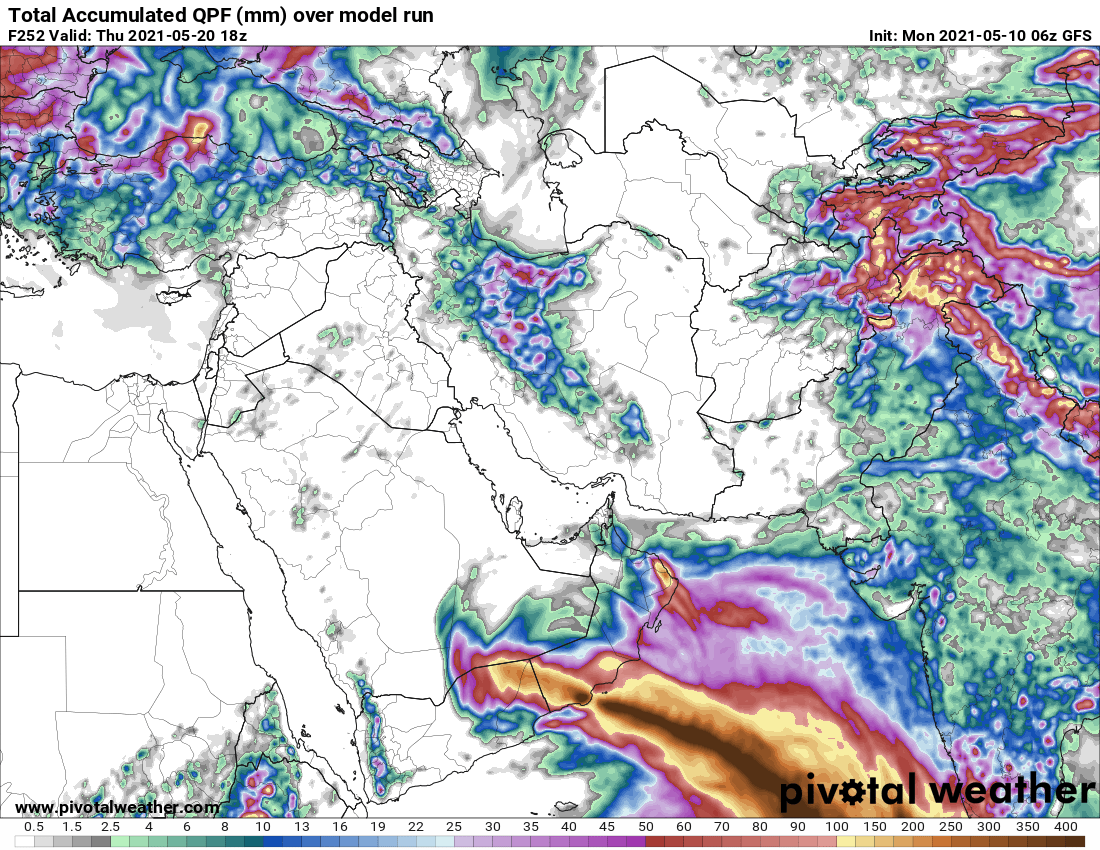
Estava reparando uns dias atrás também como o oceano está fervendo por aí, caso se confirme será um landfall bem destrutivo no Omã
GFS está prevendo mais de 500mm para certos pontos do Oman, onde chove em média anualmente um pouco mais de 100mm
-
4
-
1
-
-
9 hours ago, PabloMartins said:
Olha povo, não sei o que o GFS ta querendo fazer no Índico Norte, mas meus olhos estão atentos. Eu NUNCA vi o Índico Norte tão quente em uma região tão ampla, desde que eu monitoro as bacias tropicais (desde 2008-09).
Estava reparando uns dias atrás também como o oceano está fervendo por aí, caso se confirme será um landfall bem destrutivo no Omã
-
1
-
-
FORMA-SE A DEPRESSÃO TROPICAL ONE-E
-
2
-
1
-
-
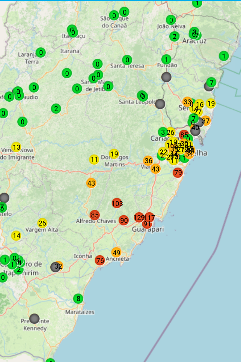
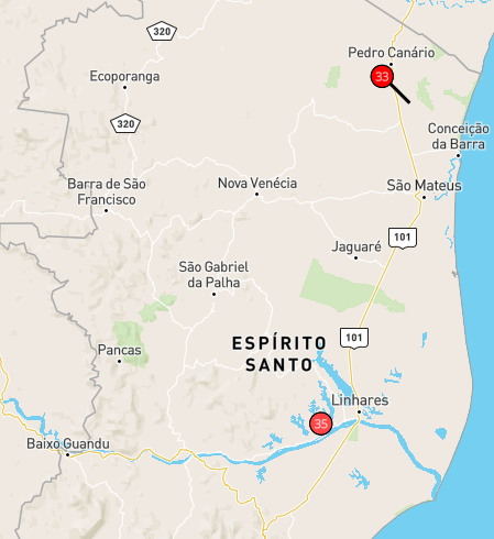
Bastante chuva na região de Guarapari/ES nas últimas 24h, por aqui até o momento só vento
-
15
-
1
-
-
-
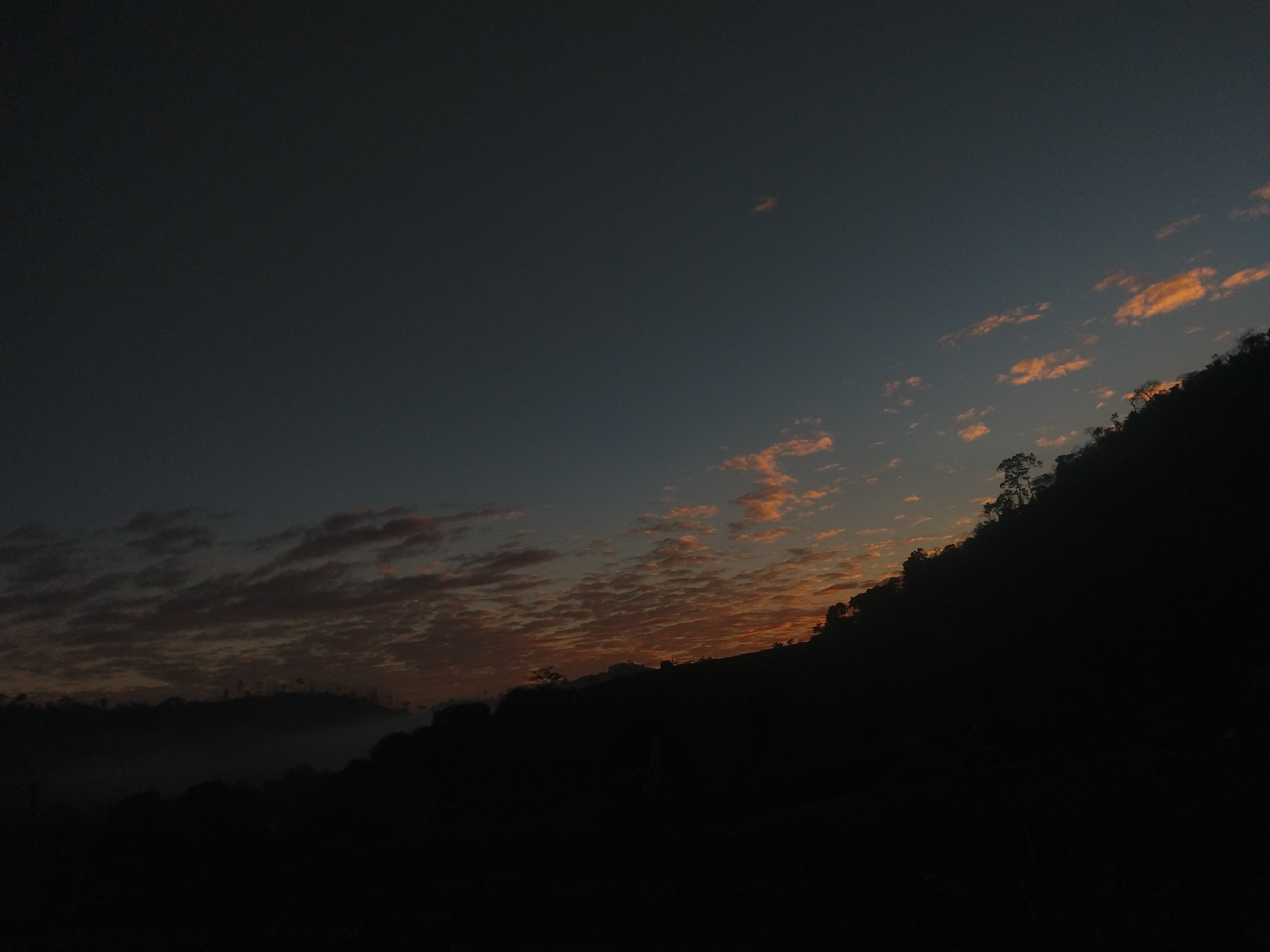
Sol segue firme aqui no norte do ES☀️
-
11
-
3
-
-
-
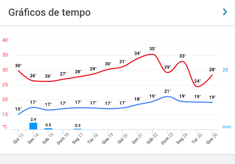
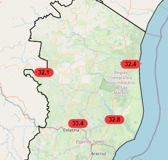
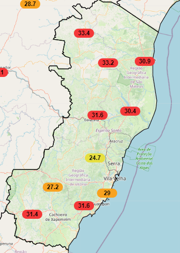
Mais um dia de calor aqui no ES, máximas entre 24,7 a 33,4 no INMET
-
14
-
-
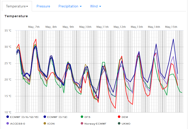
Para cá a cada rodada os modelos indicam mais frio, pro amanhecer de terça e quarta a maioria indica mínimas de 14-15ºC
AccuWeather e GEM são os mais extremos indicando mínimas de 11-12ºC
-
15
-
-
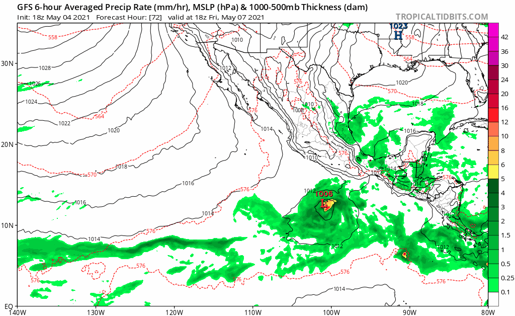
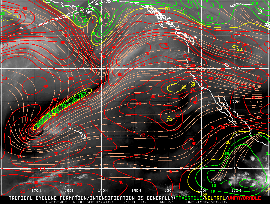
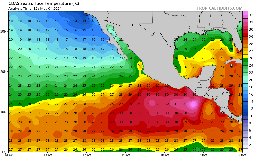
GFS continua insistindo em uma tempestade tropical pro fim de semana
Wind Shear na região continua baixo ( 5 a 20 kts )
Temperatura do oceano entre 27-30ºC
-
4
-


![[Fig. 1]](https://www.cpc.ncep.noaa.gov/products/analysis_monitoring/enso_advisory/figure01.gif)
![[Fig. 2]](https://www.cpc.ncep.noaa.gov/products/analysis_monitoring/enso_advisory/figure02.gif)
![[Fig. 3]](https://www.cpc.ncep.noaa.gov/products/analysis_monitoring/enso_advisory/figure03.gif)
![[Fig. 4]](https://www.cpc.ncep.noaa.gov/products/analysis_monitoring/enso_advisory/figure04.gif)
![[Fig. 5]](https://www.cpc.ncep.noaa.gov/products/analysis_monitoring/enso_advisory/figure05.gif)
![[Fig. 6]](https://www.cpc.ncep.noaa.gov/products/analysis_monitoring/enso_advisory/figure06.gif)
Tempo Severo EUA 2021
in Tempo Severo
Posted
RISCO MODERADO PARA HOJE
10% PARA TORNADO
30% PARA VENTO
45% PARA GRANIZO