
IgorTFreitas
-
Posts
232 -
Joined
-
Last visited
Content Type
Profiles
Forums
Gallery
Calendar
Posts posted by IgorTFreitas
-
-
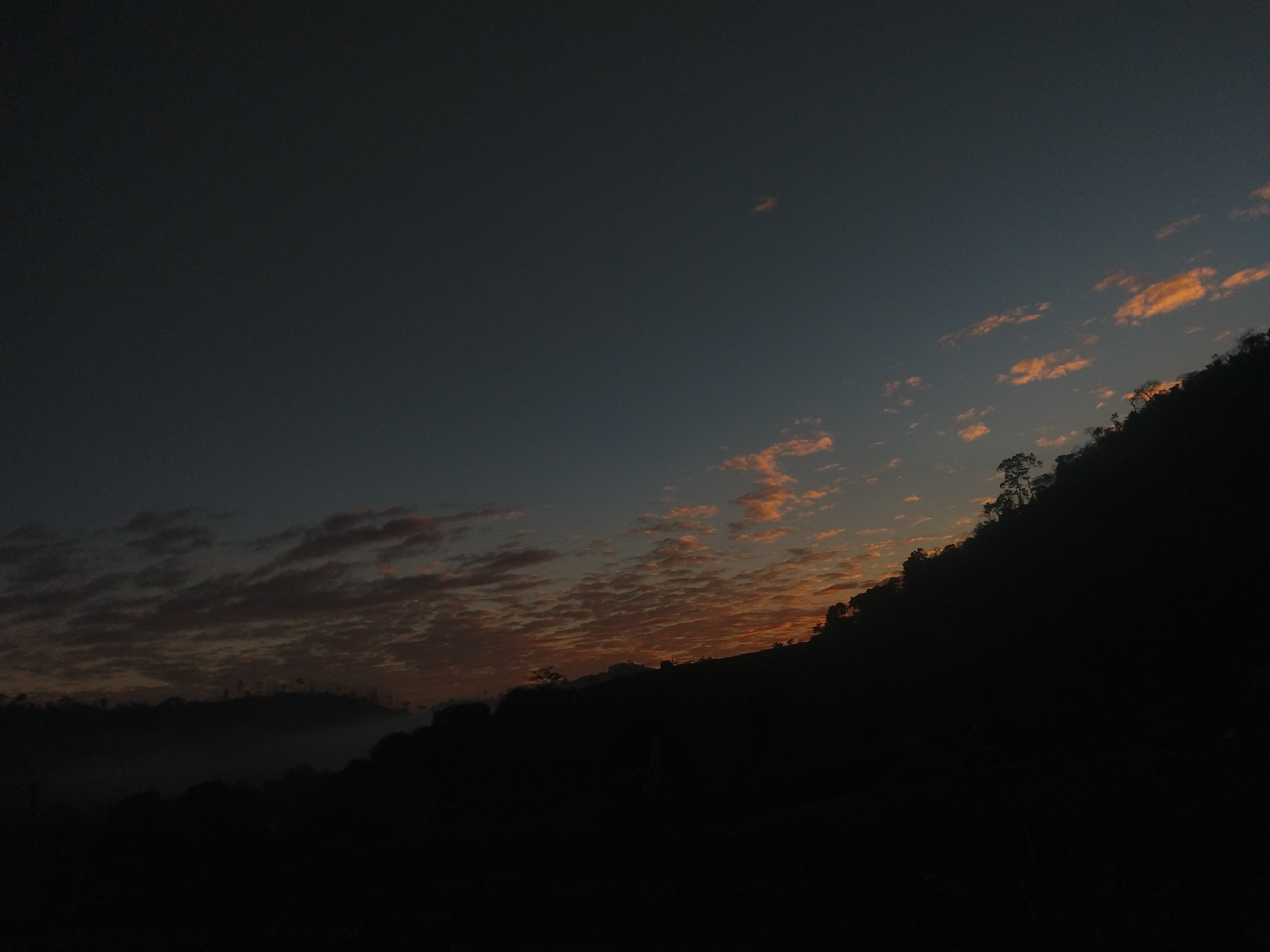
Boa tarde, hoje tive a menor temperatura do mês até agora, 15ºC, apesar que fez mais frio após o amanhecer devido ao vento.
Pra amanhã a tendência é ter os mesmos valores de temperatura ou menos ainda
-
 18
18
-
-
1 minute ago, Sinforiana Miguel Gonzale said:
Olha, eu juro que nunca vi uma invest se organizar tão rápido assim. Deixou Bertha (2020) kilometros atrás.
Durmo com uma baixa bem desorganizada c/ 10% de chaces de se formar. Acordo com 02L. O que é isso, Deus!?
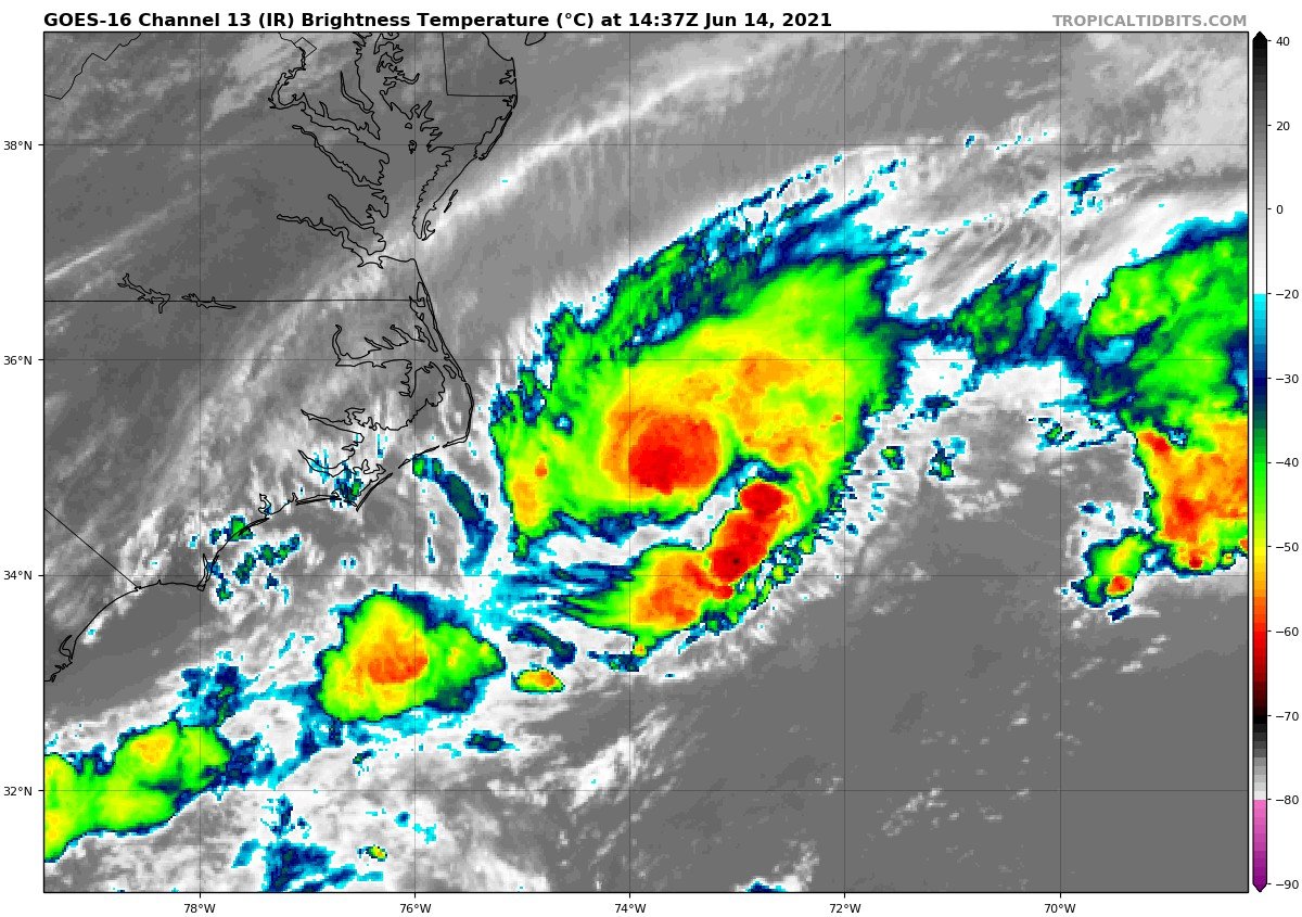
#BILL vem esta noite
DISCUSSION AND OUTLOOK
----------------------
At 1100 AM EDT (1500 UTC), the center of Tropical Depression Two was
located near latitude 35.0 North, longitude 73.7 West. The
depression is moving toward the northeast near 21 mph (33 km/h), and
this general motion is expected through Wednesday with increasing
forward speed.

Maximum sustained winds are near 35 mph (55 km/h) with higher gusts.
The depression is expected to become a tropical storm by tonight
and could continue to strengthen on Tuesday.  The system should
begin to weaken by Tuesday night and is expected to dissipate on
Wednesday.

The estimated minimum central pressure is 1006 mb (29.71 inches).

-
1
-
 1
1
-
-
-
Atlântico Norte está acordando....
-
2
-
-
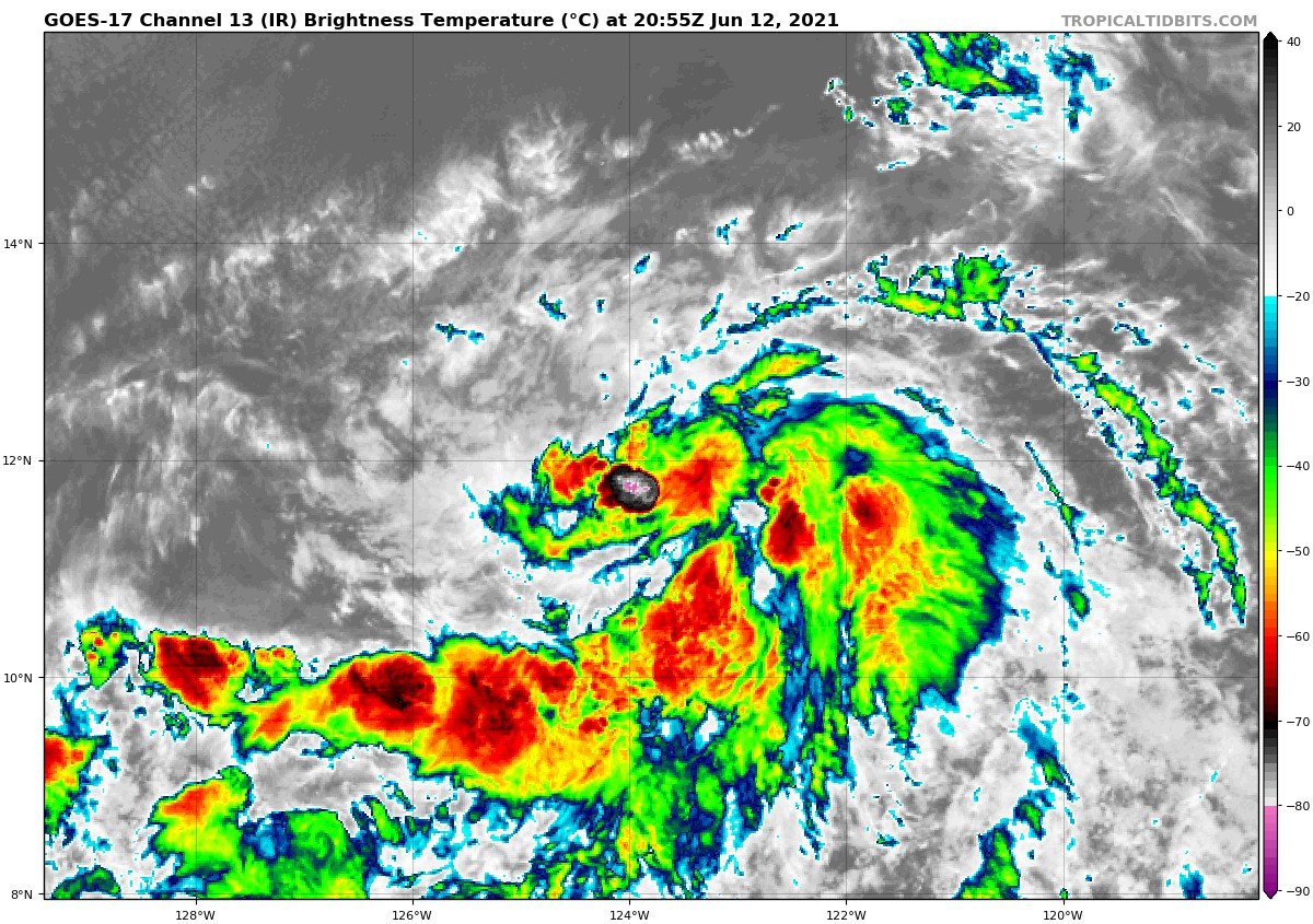
Se forma a Depressão Tropical THREE-E, esperado pra ser uma Tempestade Tropical em breve
LOCATION...11.8N 123.6W
ABOUT 1185 MI...1905 KM SW OF THE SOUTHERN TIP OF BAJA CALIFORNIA
MAXIMUM SUSTAINED WINDS...35 MPH...55 KM/H
PRESENT MOVEMENT...W OR 275 DEGREES AT 9 MPH...15 KM/H
MINIMUM CENTRAL PRESSURE...1006 MB...29.71 INCHES
-
1
-
-
Risco moderado hoje
-
3
-
-
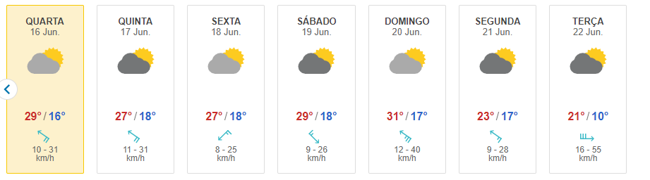
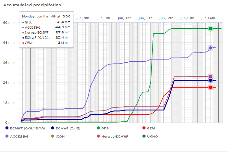
9 hours ago, IgorTFreitas said:
Pro dia 23 o EURO colocou 8ºC
Foi pra 14ºC
-
7
-
 2
2
-
 2
2
-
-
7 minutes ago, Vinicius_Pelisari said:
vou estar na serra gaucha do dia 18 a 20 de junho, será que poderá ter alguma surpresa?
Seria muita sorte , algum modelo projeta alguma precipitação invernal? Embora está mega longe para o evento
A ensemble do ECMWF pega alguma chance, bem baixa
Gramado-RS: https://meteologix.com/br/forecast/3462284-gramado/ensemble/euro/snow-precipitation-24h
Canela-RS: https://meteologix.com/br/forecast/3467530-canela/ensemble/euro/snow-precipitation-24h
São Joaquim-SC: https://meteologix.com/br/forecast/3448828-sao-joaquim/ensemble/euro/snow-precipitation-24h
-
9
-
1
-
-
1 hour ago, IgorTFreitas said:
Acerte EURO por favor
Pro dia 23 o EURO colocou 8ºC
-
12
-
-
Acerte EURO por favor
-
13
-
2
-
2
-
-
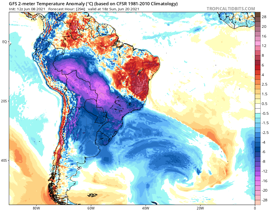
7 minutes ago, SandroAlex said:
Quem sabe junho resolve finalmente sair da zica dos últimos anos!
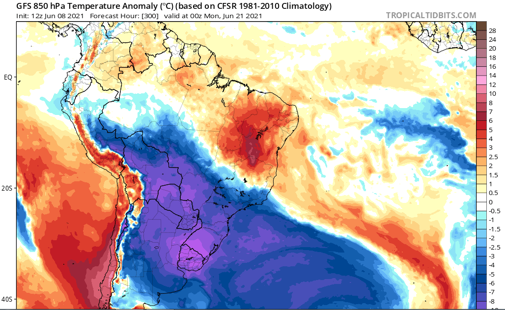
Nos 2m é mais linda ainda
-
19
-
12
-
 1
1
-
1
-
-
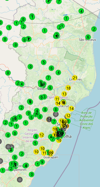
Amanhecemos com chuva por aqui, até agora registrei 10mm, outros acumulados pelo estado via CEMADEN:
Edit: Fazia cerca de 34 dias que não chovia por aqui, última vez foi dia 02/05 com 2,5mm
Pros próximos dias os modelos indicam bastante chuva com acumulados entre 20 a 50mm:
-
13
-
1
-
-
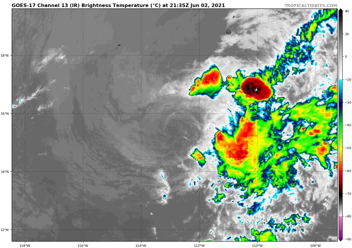
De acordo com a última discussão do NHC, é possível a formação de uma depressão tropical hoje ou amanhã
1. Showers and thunderstorms have become better organized overnight in
association with a broad area of low pressure located about 500
miles south-southwest of Manzanillo, Mexico.  Environmental
conditions appear conducive for additional development, and a
tropical depression is likely to form today or tomorrow while it
moves slowly to the west well off the coast of Mexico.
* Formation chance through 48 hours...high...80 percent.
* Formation chance through 5 days...high...80 percent.
A tendência é de intensificar e virar uma tempestade tropical, com alguns modelos mais agressivos indicando o status de furacão, vamos acompanhando....
-
1
-
-
BLANCA é agora uma depressão tropical
-
2
-
-
E finalizamos maio com incriveis 2,5mm. Última chuva foi no dia 02/05 e desde lá só caiu alguns pingos
-
7
-
1
-
4
-
-
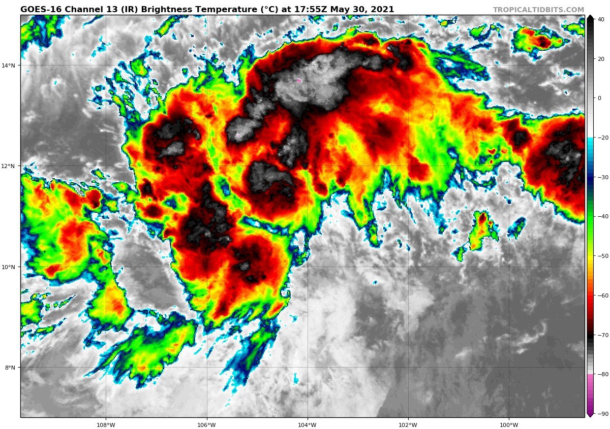
Tempestade Tropical BLANCA se forma
-
2
-
-
Chove forte no RJ, acumulados:
-
17
-
1
-
-
BLANCA vem aí:
"Any further improvement in the associated thunderstorm
activity could result in the issuance of advisories on a tropical
depression or a tropical storm later today or tonight."
Avisos para depressão ou tempestade tropical podem começar ainda hoje caso o sistema ganhe um pouquinho mais de força segundo o NHC
Última imagem de satélite:
-
2
-
-
2 hours ago, Rodolfo Alves said:
MESOCICLONE ATUANDO NA SERRA DO MAR GANHOU FORÇA, E APRESENTA DIVERGÊNCIA MAIOR.
Qual o site para esse radar de DOPPLER e VIL??
-
8
-
-
-
-
-
Só falta o #ETA agora..
-
1
-
-
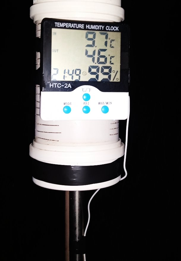
9 hours ago, Carlos Campos said:
Temperatura no topo (1,70 cm) 👇
Como você fez esse abrigo?
-
7
-


Monitoramento e Previsão - Brasil/América do Sul - Junho/2021
in Monitoramento e Previsão - América do Sul
Posted
Amanhecer frio no ES