Miguel Russe
-
Posts
777 -
Joined
-
Last visited
Content Type
Profiles
Forums
Gallery
Calendar
Posts posted by Miguel Russe
-
-
-
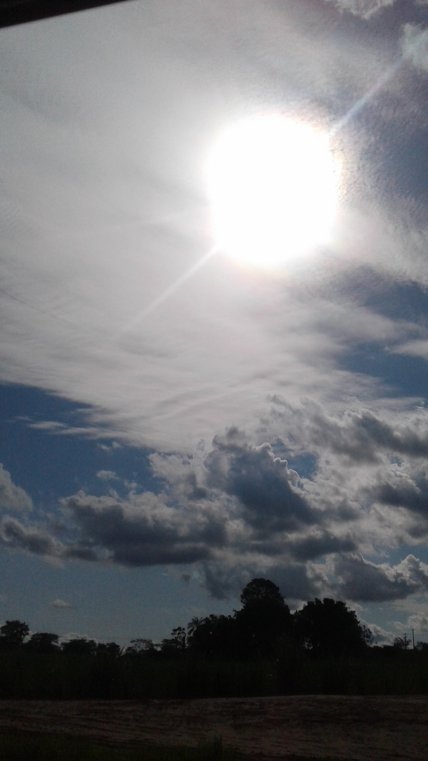
Pq o voo n quer sobrevoar essa parte, justamente a mais forte?

-
 2
2
-
-
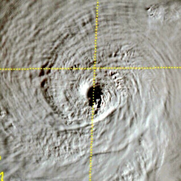
Que semelhança! Nem percebi.
-
 3
3
-
-
Aeeee
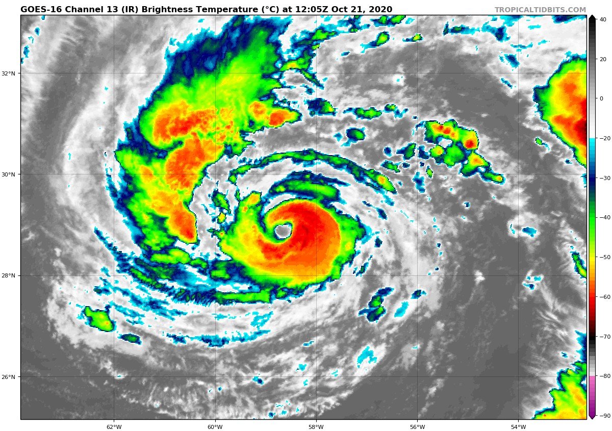
BULLETIN
Hurricane Epsilon Advisory Number  12
NWS National Hurricane Center Miami FL       AL272020
500 PM AST Wed Oct 21 2020

...EPSILON RAPIDLY INTENSIFIES INTO A MAJOR HURRICANE OVER THE
CENTRAL ATLANTIC...


SUMMARY OF 500 PM AST...2100 UTC...INFORMATION
----------------------------------------------
LOCATION...29.6N 60.0W
ABOUT 340 MI...545 KM ESE OF BERMUDA
MAXIMUM SUSTAINED WINDS...115 MPH...185 KM/H
PRESENT MOVEMENT...NW OR 305 DEGREES AT 10 MPH...17 KM/H
MINIMUM CENTRAL PRESSURE...955 MB...28.20 INCHES
-
3
-
 1
1
-
 2
2
-
-
2 horas atrás, mario junior disse:
Amigo Miguel Russe, seu sonho está a um grão de arroz de ser realizado.
000
WTNT62 KNHC 211732
TCUAT2

Hurricane Epsilon Tropical Cyclone Update
NWS National Hurricane Center Miami FL       AL272020
130 PM AST Wed Oct 21 2020

...AIR FORCE HURRICANE HUNTER AIRCRAFT FINDS EPSILON STRONGER...

Data from an Air Force Reserve Hurricane Hunter aircraft indicate
that Epsilon has continued to strengthen and now has maximum
sustained winds of 110 mph (175 km/h) with higher gusts. A Special
Advisory will be issued by 200 PM AST (1800 UTC) to reflect the
higher initial intensity and adjust the intensity forecast. This
special advisory will be issued in lieu of the 200 PM AST (1800
UTC) intermediate public advisory.


SUMMARY OF 130 PM AST...1730 UTC...INFORMATION
----------------------------------------------
LOCATION...29.3N 59.6W
ABOUT 375 MI...605 KM ESE OF BERMUDA
MAXIMUM SUSTAINED WINDS...110 MPH...175 KM/H
PRESENT MOVEMENT...WNW OR 285 DEGREES AT 12 MPH...19 KM/H
MINIMUM CENTRAL PRESSURE...959 MB...28.32 INCHES
Valeu campeão🙆✌
-
1
-
-
-
Habemus voo.
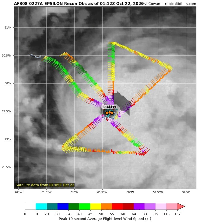
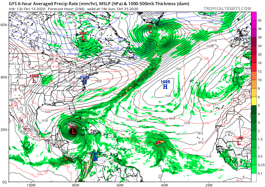
000 NOUS42 KNHC 201729 REPRPD WEATHER RECONNAISSANCE FLIGHTS CARCAH, NATIONAL HURRICANE CENTER, MIAMI, FL. 0130 PM EDT TUE 20 OCTOBER 2020 SUBJECT: TROPICAL CYCLONE PLAN OF THE DAY (TCPOD) VALID 21/1100Z TO 22/1100Z OCTOBER 2020 TCPOD NUMBER.....20-147 CORRECTION I. ATLANTIC REQUIREMENTS 1. TROPICAL STORM EPSILON FLIGHT ONE - TEAL 71 FLIGHT TWO - TEAL 72 A. 21/1730Z A. 21/2330Z,22/0530Z B. AFXXX 0127A EPSILON B. AFXXX 0227A EPSILON C. 21/1330Z C. 21/1930Z D. 28.5.0N 59.0W D. 29.0N 59.5W E. 21/1700Z TO 21/2030Z E. 21/2300Z TO 22/0530Z F. SFC TO 10,000 FT F. SFC TO 10,000 FT FLIGHT THREE - TEAL 73 (CORRECTED) A. 22/1130Z,1730Z B. AFXXX 0327A EPSILON C. 22/0730Z D. 30.0N 60.0W E. 22/1100Z TO 22/1730Z F. SFC TO 10,000 FT-
2
-
-
Vale a pena ver agora?
Voo em Delta.
-
1
-
-
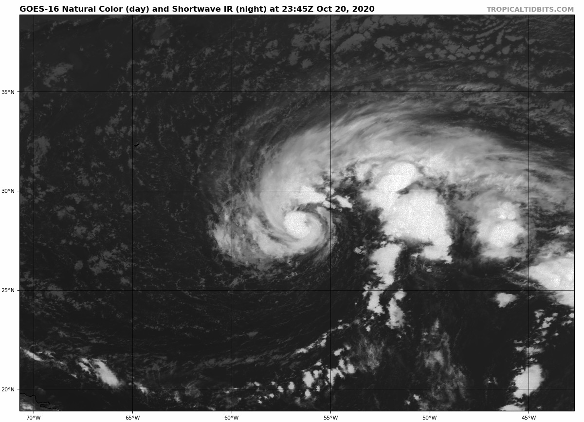
Eu estou invocado com esse CDO de Epsilon.....
Como o NHC teve coragem de manter isso aqui como um categoria 1 de 140 kph e 976 mb?
Um voo de reconhecimento ainda hoje em Epsilon seria interessante...
-
2
-
-
Boa noite!
565
WTNT32 KNHC 210235
TCPAT2

BULLETIN
Hurricane Epsilon Advisory Number   8
NWS National Hurricane Center Miami FL       AL272020
1100 PM AST Tue Oct 20 2020

...EPSILON STRENGTHENS INTO A HURRICANE...


SUMMARY OF 1100 PM AST...0300 UTC...INFORMATION
-----------------------------------------------
LOCATION...28.5N 56.8W
ABOUT 545 MI...875 KM ESE OF BERMUDA
MAXIMUM SUSTAINED WINDS...75 MPH...120 KM/H
PRESENT MOVEMENT...NW OR 310 DEGREES AT 13 MPH...20 KM/H
MINIMUM CENTRAL PRESSURE...987 MB...29.15 INCHES
-
1
-
-
-
Agora, Felipe F disse:
Epsilon deve ser atualizado para furacão na próxima atualização.
Se Deus quiser! Espero que Epsilon seja um grande furacão minimo ou um fraco categoria 2.
-
2
-
1
-
 1
1
-
-
Tropical Storm Watch emitido para as Bermudas.
-
3
-
-
Depois de agonizar 2 dias seguidos em altas chances, finalmente Twenty-Seven virou ciclone.
Como sou exagerado, eu aposto num categoria 3 minimo.
-
1
-
2
-
-
7 horas atrás, Lourenco disse:
GFS 12z agora mostra um forte furacão indo sobre Cuba
Deus te bendiga. Mas não sobre Cuba, pois não quero ver trocentas mortes. Próximos nomes são: Epsilon, Zeta, Eta e Theta.
-
2
-
1
-
-
8 horas atrás, Lourenco disse:
GFS 06Z mostra um furacão vindo do Golfo do México e atingindo a Flórida, no fim de outubro.
Coloca o mesmo furacão em 10m
-
2
-
-
Uma tropical wave está perto do caribe.
A onda deve entrar em condições não favoraveis, mas algum desenvolmento é possivel.
Na base das dúvidas, o próximo nome é Y Epsilon.
ZCZC MIATWOAT ALL
TTAA00 KNHC DDHHMM

Tropical Weather Outlook
NWS National Hurricane Center Miami FL
200 PM EDT Sat Oct 10 2020

For the North Atlantic...Caribbean Sea and the Gulf of Mexico:

The National Hurricane Center has issued its last advisory on
recently downgraded Tropical Depression Delta, centered inland over
the Lower Mississippi Valley. Future advisories will be issued by
the Weather Prediction Center.

1. A westward moving tropical wave is producing disorganized showers
and thunderstorms over the central tropical Atlantic. Slow
development of this system could be possible later this weekend or
early next week while the wave continues moving westward at 15 to
20 mph. Upper-level winds are forecast to become unfavorable for
further development by the middle of next week.
* Formation chance through 48 hours...low...10 percent.
* Formation chance through 5 days...low...20 percent.

Forecaster Beven
(Não consegui o upload da imagem, por isso ela não está aqui acima)
-
3
-
-
5 minutos atrás, Felipe F disse:
Tempestade tropical Rene também se forma no Atlântico.
"Destruiu" o recorde do Furacão Rita, 2005!
-
2
-
-
Em 03/09/2020 em 20:13, Rodolfo Alves disse:
Índico Sul: Meteofrance La Reunion/JTWC - Temporada começará em 15/11/2020 e se estenderá até 15/05/2021
Nomes da Temporada:
- Alicia
- Bongoyo
- Chalane
- Danilo
- Eloise
- Faraji
- Guambe
- Habana
- Iman
- Jobo
- Kanga
- Ludzi
- Melina
- Nathan
- Onias
- Pelagie
- Quamar
- Rita
- Solani
- Tarik
- Urilia
- Vuyane
- Wagner
- Xusa
- Yarona
- Zacarias
Lembrando que Alicia, Bongoyo, Chalane, Danilo, Eloise e Faraji são substitutos desses nomes usados pelo Météo-France na temporada de 2017-18:
- Ava
- Berguitta
- Cebile
- Dumazile
- Eliakim
- Fakir
-
5
-
Haishen se tornou uma baixa extratropical.
Creio que nas reanalises possa ser atualizado para a categoria 5.
-
2
-
-
3 horas atrás, Felipe F disse:4 sistemas sendo acompanhados no Atlântico
Nana, Omar, Paulette e Rene
-
2
-
-
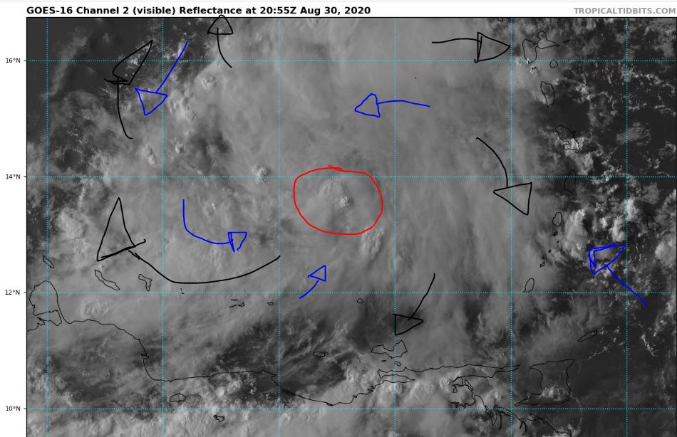
47 minutos atrás, PabloMartins disse:
Fiz uma pequena ilustração de como está a organização de 99L, vou explicar algumas coisas que até venho aprendendo ao longo do tempo e olhando vídeos de pessoas bem mais especializadas.
Em torno desse círculo vermelho, PROVAVELMENTE é onde está se estabelecendo a rotação (centro) de 99L nas baixas e médias camadas, que são as que mais importam lógico. Se tu visualizar as imagens de satélite em visível isso é muito perceptível, algo está se organizando ali e como há nas últimas horas uma atividade convectiva em crescimento ali, provavelmente é ali mesmo onde está amadurecendo a circulação.
Em azul, eu coloquei as setas de onde o fluxo nos baixos níveis da atmosfera estão se organizando e tu também consegue observar isso nas imagens que há um lindo fluxo de umidade se estabelecendo aqui.
Em preto, eu coloquei as setas do outflow lindo que 99L está adquirindo graças à um anticiclone nos níveis médios-altos da atmosfera.
O que da a entender que 99L está em condições muito favoráveis para seu desenvolvimento e intensificação, e a ciclogênese esta próxima de ocorrer. AINDA há algum ar seco em médios níveis, e isso a gente consegue ver nas imagens de satélite em vapor da água e infravermelho. NÃO HÁ QUALQUER SINAL DE "EYE FEATURE" como nosso colega mencionou acima.
Meu palpite é que 99L se consolide no máximo até amanhã e podemos sim ver Nana antes do início de Setembro, este sistema em potencial vai percorrer áreas bem favoráveis, portanto o Oeste do Caribe precisa ficar muito de olho, estamos no período do pico e que no Caribe e em 2020 tudo pode acontecer, né?!? E sinto que Nana pode virar algo grande.
Ok... Digam que que foi impressão minha!
É questão de tempo para sair um Nana. Não espero tanto desenvolmento, mas talvez possa atingir *NO MÁXIMO* um categoria 2.
A temporada de 2020 tem ido num ritmo recorde desde Cristobal.
Como ninguem mencionou, mencionarei.
Nessa decada, temos 3 temporadas que tiveram sistemas com a letra D antes de Julho (2012, 2016 e 2020).
Das três que falei acima, 2 não formaram um unico sistema se quer em Julho. Só em 2020.
Após alguns recordes no inicio da temporada de 2016, muita gente esperava uma temporada hiperativa. Isso ja era um prato perfeito pro povo fazer clickbait no youtube.
Falhou. Julho n gerou m*rda nenhuma e chegou até no Otto.
2020 gerou recordes que ate então pareciam dificeis de serem quebrados.
2020 bateu os benditos recordes numa boa.
Mas esses recordes foram batidos geralmente por ciclones bundas, exemplo disso foi Edouard, que se comparado ao antigo detentor do recorde, o Furacão Emily, Edouard vira pó.
Como dizia o @PabloMartins mais no fundo do topico, a comparação de ACE de 2020 e 2005 vem sendo horrivelmente vengonhosa. 2005 ja estava perto do 100 em ACE, 2020 n chegou nem na cintura de 2005.
-
99L criou uma “Barreira” contra o ar seco no Caribe, além ee criar um minúsculo eye-like feature:
-
2
-
2
-
1
-
-
99L foi designada ontem pelo NHC.
Tem 50% de chances de evoluir em ciclone tropical.
Pode virar TD 15L amanhã.
Próximo nome é Nana.
ZCZC MIATWOAT ALL
TTAA00 KNHC DDHHMM

Special Tropical Weather Outlook
NWS National Hurricane Center Miami FL
1210 PM EDT Sun Aug 30 2020

For the North Atlantic...Caribbean Sea and the Gulf of Mexico:

Special Tropical Weather Outlook issued to update the discussion on
the system over the eastern Caribbean Sea in the first paragraph.

1. UPDATED: Showers and thunderstorms associated with a tropical wave
over the eastern Caribbean Sea are beginning to show signs of
organization. Recent satellite-derived surface winds also indicated
that a broad low pressure system has formed in association with the
wave. Additional development of this disturbance is expected over
the next few days, and a tropical depression could form during the
next couple of days while the system moves moves westward at about
15 mph across the Caribbean Sea.  Interests in Jamaica, Honduras,
Belize, Guatemala and Yucatan should monitor the progress of this
disturbance.
* Formation chance through 48 hours...medium...50 percent.
* Formation chance through 5 days...medium...60 percent.
-
3
-
.jpeg.6e782df24ad37e1c3c89afb4c44b27de.jpeg)


.jpeg.fa323148d1fabb7a21ab42c4513a488b.jpeg)
.jpeg.5218b9b7a678725902eec81a4354fdfb.jpeg)
.png.18c5661c2916d8eccc4d9f779dc62dad.png)
Monitoramento e Previsão - Ciclones Subtropicais/Tropicais no Atlântico Sul (2016-2022)
in Monitoramento e Previsão - América do Sul
Posted
Mais um nome desperdiçado.