
Miguel Russe
-
Posts
777 -
Joined
-
Last visited
Content Type
Profiles
Forums
Gallery
Calendar
Everything posted by Miguel Russe
-
 Boa noite! 565 WTNT32 KNHC 210235 TCPAT2 BULLETIN Hurricane Epsilon Advisory Number 8 NWS National Hurricane Center Miami FL AL272020 1100 PM AST Tue Oct 20 2020 ...EPSILON STRENGTHENS INTO A HURRICANE... SUMMARY OF 1100 PM AST...0300 UTC...INFORMATION ----------------------------------------------- LOCATION...28.5N 56.8W ABOUT 545 MI...875 KM ESE OF BERMUDA MAXIMUM SUSTAINED WINDS...75 MPH...120 KM/H PRESENT MOVEMENT...NW OR 310 DEGREES AT 13 MPH...20 KM/H MINIMUM CENTRAL PRESSURE...987 MB...29.15 INCHES
 -
atualizando...
-
Se Deus quiser! Espero que Epsilon seja um grande furacão minimo ou um fraco categoria 2.
-
Tropical Storm Watch emitido para as Bermudas.
-
Depois de agonizar 2 dias seguidos em altas chances, finalmente Twenty-Seven virou ciclone. Como sou exagerado, eu aposto num categoria 3 minimo.
-
Deus te bendiga. Mas não sobre Cuba, pois não quero ver trocentas mortes. Próximos nomes são: Epsilon, Zeta, Eta e Theta.
-
Coloca o mesmo furacão em 10m
-
Uma tropical wave está perto do caribe. A onda deve entrar em condições não favoraveis, mas algum desenvolmento é possivel. Na base das dúvidas, o próximo nome é Y Epsilon. ZCZC MIATWOAT ALL TTAA00 KNHC DDHHMM Tropical Weather Outlook NWS National Hurricane Center Miami FL 200 PM EDT Sat Oct 10 2020 For the North Atlantic...Caribbean Sea and the Gulf of Mexico: The National Hurricane Center has issued its last advisory on recently downgraded Tropical Depression Delta, centered inland over the Lower Mississippi Valley. Future advisories will be issued by the Weather Prediction Center. 1. A westward moving tropical wave is producing disorganized showers and thunderstorms over the central tropical Atlantic. Slow development of this system could be possible later this weekend or early next week while the wave continues moving westward at 15 to 20 mph. Upper-level winds are forecast to become unfavorable for further development by the middle of next week. * Formation chance through 48 hours...low...10 percent. * Formation chance through 5 days...low...20 percent. Forecaster Beven (Não consegui o upload da imagem, por isso ela não está aqui acima)
-
"Destruiu" o recorde do Furacão Rita, 2005!
-
Lembrando que Alicia, Bongoyo, Chalane, Danilo, Eloise e Faraji são substitutos desses nomes usados pelo Météo-France na temporada de 2017-18: Ava Berguitta Cebile Dumazile Eliakim Fakir
-
Haishen se tornou uma baixa extratropical. Creio que nas reanalises possa ser atualizado para a categoria 5.
-
Nana, Omar, Paulette e Rene
-
Ok... Digam que que foi impressão minha! É questão de tempo para sair um Nana. Não espero tanto desenvolmento, mas talvez possa atingir *NO MÁXIMO* um categoria 2. A temporada de 2020 tem ido num ritmo recorde desde Cristobal. Como ninguem mencionou, mencionarei. Nessa decada, temos 3 temporadas que tiveram sistemas com a letra D antes de Julho (2012, 2016 e 2020). Das três que falei acima, 2 não formaram um unico sistema se quer em Julho. Só em 2020. Após alguns recordes no inicio da temporada de 2016, muita gente esperava uma temporada hiperativa. Isso ja era um prato perfeito pro povo fazer clickbait no youtube. Falhou. Julho n gerou m*rda nenhuma e chegou até no Otto. 2020 gerou recordes que ate então pareciam dificeis de serem quebrados. 2020 bateu os benditos recordes numa boa. Mas esses recordes foram batidos geralmente por ciclones bundas, exemplo disso foi Edouard, que se comparado ao antigo detentor do recorde, o Furacão Emily, Edouard vira pó. Como dizia o @PabloMartins mais no fundo do topico, a comparação de ACE de 2020 e 2005 vem sendo horrivelmente vengonhosa. 2005 ja estava perto do 100 em ACE, 2020 n chegou nem na cintura de 2005.
-
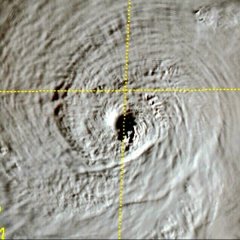
99L criou uma “Barreira” contra o ar seco no Caribe, além ee criar um minúsculo eye-like feature:
-
99L foi designada ontem pelo NHC. Tem 50% de chances de evoluir em ciclone tropical. Pode virar TD 15L amanhã. Próximo nome é Nana. ZCZC MIATWOAT ALL TTAA00 KNHC DDHHMM Special Tropical Weather Outlook NWS National Hurricane Center Miami FL 1210 PM EDT Sun Aug 30 2020 For the North Atlantic...Caribbean Sea and the Gulf of Mexico: Special Tropical Weather Outlook issued to update the discussion on the system over the eastern Caribbean Sea in the first paragraph. 1. UPDATED: Showers and thunderstorms associated with a tropical wave over the eastern Caribbean Sea are beginning to show signs of organization. Recent satellite-derived surface winds also indicated that a broad low pressure system has formed in association with the wave. Additional development of this disturbance is expected over the next few days, and a tropical depression could form during the next couple of days while the system moves moves westward at about 15 mph across the Caribbean Sea. Interests in Jamaica, Honduras, Belize, Guatemala and Yucatan should monitor the progress of this disturbance. * Formation chance through 48 hours...medium...50 percent. * Formation chance through 5 days...medium...60 percent.
-
Laura causou prejuíjos de 8 bilhões de dólares até agora, segundo a imprensa americana. 51 mortes relacionadas ao furacão, segundo estiamtivas dos países onde laura afetou.
-
Maysak se torna o quarto tufão de 2020. Atualmente ameaça o Japão e suas ilha e o sul da coreia do sul. HWRF-P confiante em Maysak: 150 mph e 912 mbar Obs: Maysak foi nomeado ontem...
-
Temos 2 ondas tropicais no ATL. A segunda deve se desenvolver, mas primeira não. Próximo nome é Nana. ZCZC MIATWOAT ALL TTAA00 KNHC DDHHMM Tropical Weather Outlook NWS National Hurricane Center Miami FL 200 PM EDT Thu Aug 27 2020 For the North Atlantic...Caribbean Sea and the Gulf of Mexico: The National Hurricane Center is issuing advisories on Tropical Storm Laura, located inland over northwestern Louisiana. 1. A westward-moving tropical wave located over the far eastern tropical Atlantic near the Cabo Verde Islands continues to produce disorganized shower activity. Although environmental conditions are not expected to be conducive for development during the next couple of days, they are forecast to gradually become more favorable over the weekend and into early next week when the wave moves into the central and then western tropical Atlantic. * Formation chance through 48 hours...low...near 0 percent. * Formation chance through 5 days...low...20 percent. 2. Shower and thunderstorm activity has increased today in association with a tropical wave over the central tropical Atlantic. Gradual development of this system is possible over the next several days as it moves westward at 15 to 20 mph. * Formation chance through 48 hours...low...10 percent. * Formation chance through 5 days...low...30 percent. (Obs: eu não trouxe as imagens pq o upload daqui falhou)
-
Parece o Furacão Michael depois do landfall
-
Aqui temos uma porção de profissionais e/ou experientes no assunto! Agradeçam a eles! (Felipe F, Rodolfo Alves, Pablo Martins, Tavares e outros)
-
Não foi atualizado para a categoria 5! Vá em paz, Laurinha! Teu esforço valeu a pena.... (rs) 227 WTNT33 KNHC 270253 TCPAT3 BULLETIN Hurricane Laura Advisory Number 29 NWS National Hurricane Center Miami FL AL132020 1000 PM CDT Wed Aug 26 2020 ...EXTREMELY DANGEROUS HURRICANE LAURA CLOSING IN ON THE NORTHWEST GULF COAST... ...CATASTROPHIC STORM SURGE, EXTREME WINDS, AND FLASH FLOODING EXPECTED TONIGHT AND EARLY THURSDAY... SUMMARY OF 1000 PM CDT...0300 UTC...INFORMATION ----------------------------------------------- LOCATION...29.0N 93.2W ABOUT 75 MI...120 KM S OF LAKE CHARLES LOUISIANA ABOUT 75 MI...120 KM SE OF PORT ARTHUR TEXAS MAXIMUM SUSTAINED WINDS...150 MPH...240 KM/H PRESENT MOVEMENT...NNW OR 340 DEGREES AT 15 MPH...24 KM/H MINIMUM CENTRAL PRESSURE...939 MB...27.73 INCHES
-
aaa ribamar 000 WTNT63 KNHC 270152 TCUAT3 Hurricane Laura Tropical Cyclone Update NWS National Hurricane Center Miami FL AL132020 900 PM CDT Wed Aug 26 2020 ...900 PM CDT POSITION UPDATE... A sustained wind of 45 mph (72 km/h) was recently reported at Cypremort Point, Louisiana, on Vermilion Bay. SUMMARY OF 900 PM CDT...0200 UTC...INFORMATION ---------------------------------------------- LOCATION...28.8N 93.1W ABOUT 90 MI...145 KM S OF LAKE CHARLES LOUISIANA ABOUT 90 MI...145 KM SSE OF PORT ARTHUR TEXAS MAXIMUM SUSTAINED WINDS...150 MPH...240 KM/H PRESENT MOVEMENT...NNW OR 335 DEGREES AT 15 MPH...24 KM/H MINIMUM CENTRAL PRESSURE...937 MB...27.67 INCHES
-
001430 2844N 09300W 6974 02744 9556 +129 //// 096132 140 133 062 01 001500 2846N 09300W 6959 02808 9625 +113 //// 093139 141 137 054 05
-
Pressão caiu para 939 mbar 230500 2814N 09254W 6958 02682 9393 +218 +079 268015 016 022 005 00
-
Laura segue ganhando força. Encontrados ventos compatíveis com a categoria 5. 230000 2829N 09240W 6968 02857 9689 +115 //// 125135 139 107 080 01 230030 2828N 09242W 6952 02826 9622 +124 //// 127138 140 112 086 05


