
Miguel Russe
-
Posts
777 -
Joined
-
Last visited
Content Type
Profiles
Forums
Gallery
Calendar
Posts posted by Miguel Russe
-
-
É isso! (Por enquanto).
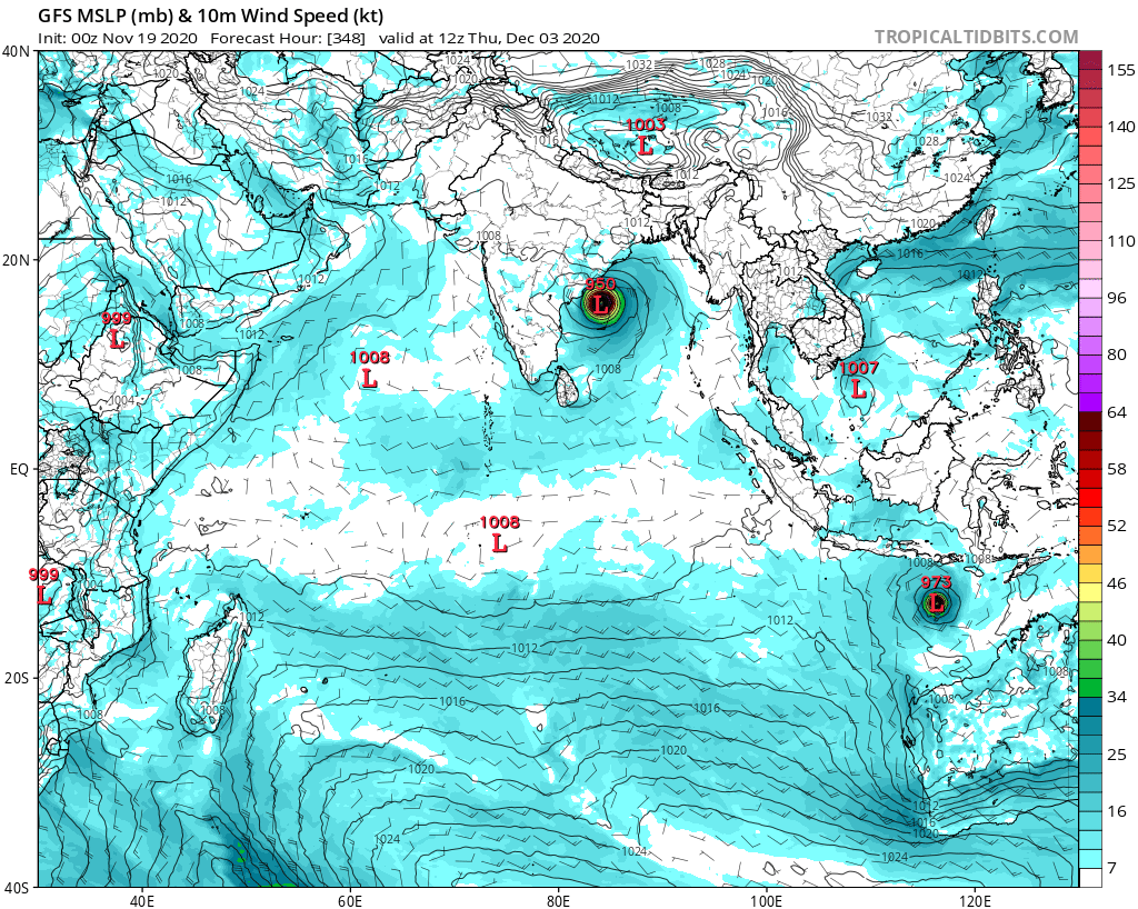
A baixa nos açores foi nomeada CLEMENT pelo AEMET.
O NHC descartou quaisquer chances de desenvolvimento agora devido ao alto wind shear, ar seco e aguas frias.
Se não for por agora, Kappa virá mais pra frente nesse ultimo mes de 2020, ou daqui uns 10 - 100 anos.
2020 Atlantic hurricane season:
Estatísticas sazonais
Depressões totais 31 (recorde, empatado com 2005 ) Tempestades totais 30 (recorde) Furacões 13 Grandes furacões
( Cat. 3+ )6 Total de fatalidades ≥ 436 no total Dano total > $ 41 bilhões (2020 USD ) -
 1
1
-
-
2020 marcou sua historia no livro meteorologico.
Nem no ante-penultimo dia da temporada a atividade não para!
Muito ciclone para tampouco ACE.
Era para estar tirando a casquinha dos 270 ACE.

ZCZC MIATWOAT ALL
TTAA00 KNHC DDHHMM

Tropical Weather Outlook
NWS National Hurricane Center Miami FL
700 AM EST Sat Nov 28 2020

For the North Atlantic...Caribbean Sea and the Gulf of Mexico:

1. A non-tropical low pressure system located about 650 miles southeast
of Bermuda is producing a few disorganized showers and thunderstorms
to the north and east of the center. Environmental conditions are
expected to be only marginally conducive for development during the
next day or so as the low moves northeastward before it is absorbed
by an approaching frontal system over the north-central Atlantic.
* Formation chance through 48 hours...low...30 percent.
* Formation chance through 5 days...low...30 percent.

2. A non-tropical low pressure system over the far eastern Atlantic is
expected to move southward about midway between Portugal and the
Azores over the weekend. Environmental conditions are forecast to be
marginally conducive for the low to acquire subtropical
characteristics early next week while it meanders just to the north
of the Canary Islands. Additional information on this system can be
found in high seas forecasts issued by Meteo France.
* Formation chance through 48 hours...low...10 percent.
* Formation chance through 5 days...low...30 percent.
-
 2
2
-
-
Burevi, Tauktae, Imogen e Bongoyo
-
1
-
-
Gente, é verdade que o Maradona se foi?
Estou em choque. Meu idolo se foi😥
-
 6
6
-
-
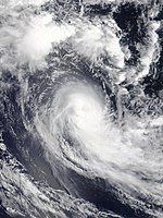
Ciclone Gati explode e vai para a cetegoria 3.
IMD manteve Gati como ciclonic storm.
Que lentidão IMD.
MSGID/GENADMIN/JOINT TYPHOON WRNCEN PEARL HARBOR HI// SUBJ/TROPICAL CYCLONE 03A (GATI) WARNING NR 003// RMKS/ 1. TROPICAL CYCLONE 03A (GATI) WARNING NR 003 01 ACTIVE TROPICAL CYCLONE IN NORTHIO MAX SUSTAINED WINDS BASED ON ONE-MINUTE AVERAGE WIND RADII VALID OVER OPEN WATER ONLY --- WARNING POSITION: 220600Z --- NEAR 10.3N 52.5E MOVEMENT PAST SIX HOURS - 260 DEGREES AT 14 KTS POSITION ACCURATE TO WITHIN 015 NM POSITION BASED ON EYE FIXED BY SATELLITE PRESENT WIND DISTRIBUTION: MAX SUSTAINED WINDS - 100 KT, GUSTS 125 KT WIND RADII VALID OVER OPEN WATER ONLY RADIUS OF 064 KT WINDS - 015 NM NORTHEAST QUADRANT 015 NM SOUTHEAST QUADRANT 010 NM SOUTHWEST QUADRANT 010 NM NORTHWEST QUADRANT RADIUS OF 050 KT WINDS - 025 NM NORTHEAST QUADRANT 025 NM SOUTHEAST QUADRANT 020 NM SOUTHWEST QUADRANT 020 NM NORTHWEST QUADRANT RADIUS OF 034 KT WINDS - 040 NM NORTHEAST QUADRANT 040 NM SOUTHEAST QUADRANT 035 NM SOUTHWEST QUADRANT 045 NM NORTHWEST QUADRANT REPEAT POSIT: 10.3N 52.5E-
2
-
-
-
Eu estou assustado. Q raridadade e essa?
-
5
-
-
Nivar 950 mbar/Imogen 954 mbar
-
4
-
-
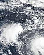
Começou a "South-West Indian Ocean Cyclone Season 2020-21".
Já tivemos 2 sistemas tropicais.
Aicia e TD 02.
Alicia ficou por 18 horas como "Tropical Cyclone" pelo MFR e o mesmo tempo ficou na categoria 1.
Alicia é um Ex-Ciclone Tropical agora.
Alicia:
02:
-
3
-
-
Em 17/11/2020 em 00:34, Felipe F disse:
IOTA fazendo landfall neste momento
Iota debochado.
Com Kappa, ainda temos MUuuuuuita atividade no ATL!....(sem graça!)
ZCZC MIATWOAT ALL
TTAA00 KNHC DDHHMM

Tropical Weather Outlook
NWS National Hurricane Center Miami FL
100 PM EST Wed Nov 18 2020

For the North Atlantic...Caribbean Sea and the Gulf of Mexico:

The National Hurricane Center has issued the last advisory on the
remnants of Iota, located inland over El Salvador.

1. A broad area of low pressure could form in a day or so over the
southwestern Caribbean Sea.  Development, if any, of this system is
expected to slow to occur during the next several days while the
it moves slowly west-southwestward or westward across the
southwestern Caribbean Sea.  Regardless of tropical cyclone
formation, areas of heavy rain are possible during the next several
days from Nicaragua southward across Central America and into
Colombia.  These rains could cause new flooding concerns, especially
across previously inundated areas.
* Formation chance through 48 hours...low...near 0 percent.
* Formation chance through 5 days...low...10 percent.

2. A non-tropical area of low pressure could form between the Bahamas
and Bermuda by early next week.  The system could gradually develop
subtropical characteristics through the middle of next week while it
moves northeastward.
* Formation chance through 48 hours...low...near 0 percent.
* Formation chance through 5 days...low...20 percent.
-
3
-
-
TD 21-E se forma no Pacífico.
000
WTPZ31 KNHC 172042
TCPEP1

BULLETIN
Tropical Depression Twenty-One-E Advisory Number   1
NWS National Hurricane Center Miami FL       EP212020
300 PM MDT Tue Nov 17 2020

...LATE-SEASON TROPICAL DEPRESSION FORMS OVER THE OPEN WATERS OF
THE EASTERN PACIFIC...


SUMMARY OF 300 PM MDT...2100 UTC...INFORMATION
----------------------------------------------
LOCATION...15.2N 113.3W
ABOUT 575 MI...925 KM SSW OF THE SOUTHERN TIP OF BAJA CALIFORNIA
MAXIMUM SUSTAINED WINDS...35 MPH...55 KM/H
PRESENT MOVEMENT...WNW OR 285 DEGREES AT 12 MPH...19 KM/H
MINIMUM CENTRAL PRESSURE...1007 MB...29.74 INCHES
-
3
-
-
💧Agora, Vamos ficar de 👀 em 🌀Kappa☔!
ZCZC MIATWOAT ALL
TTAA00 KNHC DDHHMM

Tropical Weather Outlook
NWS National Hurricane Center Miami FL
700 PM EST Mon Nov 16 2020

For the North Atlantic...Caribbean Sea and the Gulf of Mexico:

The National Hurricane Center is issuing advisories on Hurricane
Iota, located over the southwestern Caribbean Sea near the coast of
northeastern Nicaragua.

1. A new area of low pressure could form in a couple of days over the
central or southwestern Caribbean Sea.  Environmental conditions
are forecast to be conducive for some development, and a tropical
depression could form by the end of the week while the system moves
slowly westward or west-southwestward across the southwestern
Caribbean Sea.
* Formation chance through 48 hours...low...near 0 percent.
* Formation chance through 5 days...medium...40 percent.
-
4
-
-
Agora, Felipe F disse:
...EXTREMELY DANGEROUS HURRICANE IOTA MAKES LANDFALL ALONG THE COAST OF NORTHEASTERN NICARAGUA... ...LIFE-THREATENING STORM SURGE, CATASTROPHIC WINDS, FLASH FLOODING, AND LANDSLIDES EXPECTED ACROSS PORTIONS OF CENTRAL AMERICA...
Category 4 Hurricane Iota, with sustained winds near 155 mph (250 km/h), made landfall along the northeastern coast of Nicaragua near the town of Haulover, or about 30 miles (45 km) south of Puerto Cabezas, at 1040 PM EST...0340 UTC...this Monday evening.
Hurricane Iota's landfall location is approximately 15 miles (25 km) south of where Category 4 Hurricane Eta made landfall earlier this month on November 3rd.
Mah, perdeu a graça.
Jesus proteja a Nicaragua, e mais ainda Honduras.
Eta atingiu a Nicaragua com ventos de 225 km/h e matou menos de 50 pessoas.
Depois entrou na Nicaragua ja como TD e matou mais de 150 pessoas.
Tomara que os danos sejam semelhantes ao de Arthur no inicio da temporada. (112.000 US).
Digamos que é impossível os danos serem abaixo de 1 bn US, mas torço fique estacionado em 3 o numero de deaths
-
2
-
1
-
-
Downgraded
000
WTNT31 KNHC 170234
TCPAT1

BULLETIN
Hurricane Iota Advisory Number  15
NWS National Hurricane Center Miami FL       AL312020
1000 PM EST Mon Nov 16 2020

...EXTREMELY DANGEROUS IOTA EXPECTED TO MAKE LANDFALL VERY SOON...
...CATASTROPHIC WINDS, LIFE-THREATENING STORM SURGE, AND TORRENTIAL
RAINFALL OCCURRING IN CENTRAL AMERICA...


SUMMARY OF 1000 PM EST...0300 UTC...INFORMATION
-----------------------------------------------
LOCATION...13.6N 83.4W
ABOUT 30 MI...45 KM S OF PUERTO CABEZAS NICARAGUA
ABOUT 100 MI...155 KM S OF CABO GRACIAS A DIOS ON NIC/HON BORDER
MAXIMUM SUSTAINED WINDS...155 MPH...250 KM/H
PRESENT MOVEMENT...W OR 275 DEGREES AT 9 MPH...15 KM/H
MINIMUM CENTRAL PRESSURE...920 MB...27.17 INCHES
-
4
-
-
Agora, Renan disse:
Já tivemos Landfall de algum furacão no litoral norte da América do Sul ?
Vários.
Aqui no link abaixo está uma lista enorme. É só traduzir para um melhor entendimento.
Link: "https://en.m.wikipedia.org/wiki/List_of_South_America_hurricanes"
-
6
-
 1
1
-
-
Ate que enfim....
ZCZC MIATCPAT1 ALL
TTAA00 KNHC DDHHMM

BULLETIN
Hurricane Iota Advisory Number  13
NWS National Hurricane Center Miami FL       AL312020
1000 AM EST Mon Nov 16 2020

...IOTA BECOMES A CATEGORY 5 HURRICANE...
...FORECAST TO BRING CATASTROPHIC WINDS, LIFE-THREATENING STORM
SURGE, AND TORRENTIAL RAINFALL TO CENTRAL AMERICA...


SUMMARY OF 1000 AM EST...1500 UTC...INFORMATION
-----------------------------------------------
LOCATION...13.5N 82.0W
ABOUT 40 MI...65 KM W OF ISLA DE PROVIDENCIA COLOMBIA
ABOUT 100 MI...160 KM ESE OF PUERTO CABEZAS NICARAGUA
MAXIMUM SUSTAINED WINDS...160 MPH...260 KM/H
PRESENT MOVEMENT...W OR 270 DEGREES AT 9 MPH...15 KM/H
MINIMUM CENTRAL PRESSURE...917 MB...27.08 INCHES
-
5
-
-
Agora, Felipe F disse:
Iota
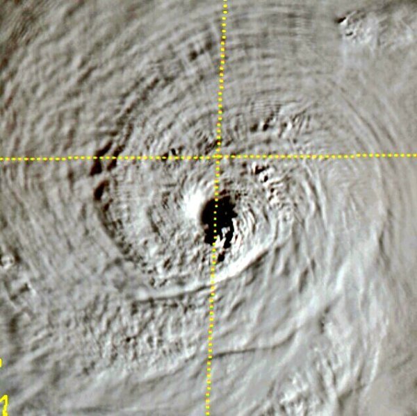
O olho de Iota ficou bugado.....
-
2
-
-
Agora, Felipe F disse:
Best Track - Categoria 5
NHC deve atualizar em breve!
oh glória!
Os próximos cat 5 são Laura e Eita.
-
3
-
-
Agora, Felipe F disse:
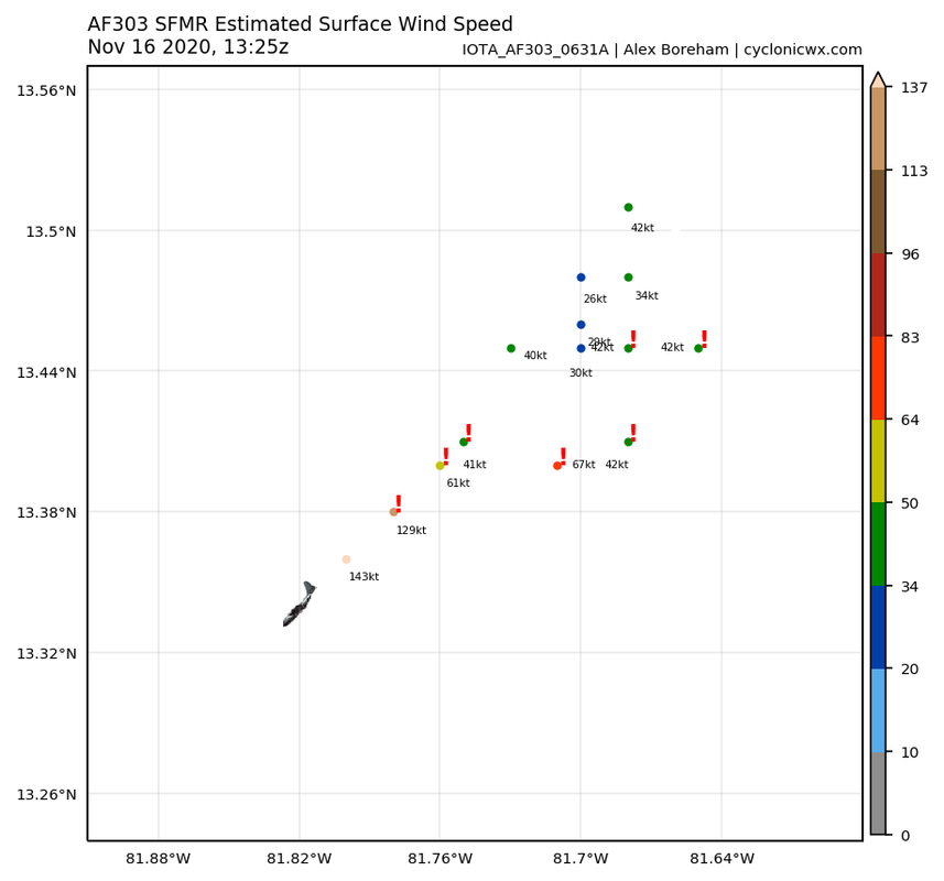
Dados da segunda passagem: Pressure 913.5 mbar, 143 kt SFMR.
Será agora que vai p categoria 5?
-
1
-
-
BULLETIN
Hurricane Iota Intermediate Advisory Number 12A
NWS National Hurricane Center Miami FL       AL312020
700 AM EST Mon Nov 16 2020

...AIR FORCE HURRICANE HUNTERS ALMOST IN THE CORE OF IOTA...
...IOTA EXPECTED TO BRING CATASTROPHIC WINDS, LIFE-THREATENING
STORM SURGE, AND EXTREME RAINFALL IMPACTS TO CENTRAL AMERICA...


SUMMARY OF 700 AM EST...1200 UTC...INFORMATION
----------------------------------------------
LOCATION...13.5N 81.6W
ABOUT 20 MI...35 KM NW OF ISLA DE PROVIDENCIA COLOMBIA
ABOUT 145 MI...235 KM SE OF CABO GRACIAS A DIOS ON NIC/HON BORDER
MAXIMUM SUSTAINED WINDS...155 MPH...245 KM/H
PRESENT MOVEMENT...W OR 275 DEGREES AT 10 MPH...17 KM/H
MINIMUM CENTRAL PRESSURE...925 MB...27.32 INCHES
Falta pouco...
-
4
-
-
Bom di......
000
WTNT61 KNHC 160644
TCUAT1

Hurricane Iota Tropical Cyclone Update
NWS National Hurricane Center Miami FL       AL312020
140 AM EST Mon Nov 16 2020

...AIR FORCE RESERVE RECONNAISSANCE AIRCRAFT FINDS IOTA HAS RAPIDLY
STRENGTHENED INTO A DANGEROUS CATEGORY 4 HURRICANE...

Air Force Reserve hurricane hunter aircraft data indicate that Iota
now has maximum sustained winds of 140 mph (225 km/h) with higher
gusts. The minimum pressure measured by the plane was 935 mb (27.61
inches). The updated intensity will be reflected in the next
advisory which will be issued by 400 AM EST.

SUMMARY OF 140 AM EST...0640 UTC...INFORMATION
----------------------------------------------
LOCATION...13.5N 80.7W
ABOUT 45 MI...70 KM ENE OF ISLA DE PROVIDENCIA COLOMBIA
ABOUT 190 MI...310 KM ESE OF CABO GRACIAS A DIOS ON NIC/HON BORDER
MAXIMUM SUSTAINED WINDS...140 MPH...225 KM/H
PRESENT MOVEMENT...W OR 280 DEGREES AT 10 MPH...17 KM/H
MINIMUM CENTRAL PRESSURE...935 MB...27.61 INCHES
-
1
-
-
Vou na casa 4
130 mph e 952 mbar
-
2
-
-
Estimaria 115 mph e 964 mbar.
-
1
-
-
Agora, Tavares disse:
Tropical Cyclone Outbreak
Kappo?!
.png.975eda82c53389010b268aaf2e91ea5c.png)
.png.68f07d48cd38264a0b597fe015dce84a.png)
.jpg.dd850e8d6c36f465093144473977f348.jpg)
.png.42568c3e51ead85631741a5eb4314142.png)
.png.a400aeb19ad2358bf356e4aad4bc4b12.png)


.png.9876c35948763153feebc638a428eeb5.png)

.png.a8611262555564f3197ffd3337122763.png)


.jpeg.dbf212f0d65b09688dfde3c134e5a4cf.jpeg)

Ciclones Tropicais no Índico e Pacífico Sul/Austrália - 2020/2021
in Monitoramento de Furacões, Tufões e Ciclones Tropicais
Posted
956 mb - Yasa (Yolanda)