Miguel Russe
-
Posts
777 -
Joined
-
Last visited
Content Type
Profiles
Forums
Gallery
Calendar
Posts posted by Miguel Russe
-
-
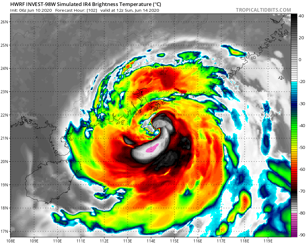
A tendência do modelo HWRF veio sendo muito agressivo mediante a intensidade de 98W (Nuri) sobre as filipinas e china, podendo causar muitos danos por onde passar.

O modelo mostra 98W atingindo a China como um tufão bem forte.
Mas 98W ja é um ciclone um pouco interessante para acompanhar, devido a certas incertezas dos modelos sobre a intensidade da tormenta.
-
 2
2
-
-
94B começa a ser monitorada na baía de bengala.
Deve virar Ciclone Gati nos proximos dias.
MSGID/GENADMIN/JOINT TYPHOON WRNCEN PEARL HARBOR HI// SUBJ/SIGNIFICANT TROPICAL WEATHER ADVISORY FOR THE INDIAN OCEAN /REISSUED/101300Z-101800ZJUN2020// RMKS/ 1. NORTH INDIAN OCEAN AREA (MALAY PENINSULA WEST TO COAST OF AFRICA): A. TROPICAL CYCLONE SUMMARY: NONE. B. TROPICAL DISTURBANCE SUMMARY: (1) AN AREA OF CONVECTION (INVEST 94B) HAS PERSISTED NEAR 16.6N 88.5E, APPROXIMATELY 350 NM SOUTH OF KOLKATA, INDIA. ANIMATED MULTISPECTRAL SATELLITE IMAGERY SHOWS LOW LEVEL BANDING WRAPPING INTO A WELL DEFINED LLCC. A 100315Z ASCAT-A IMAGE ALSO SHOWS A WELL DEFINED CIRCULATION WITH 10-15 KNOT WINDS. 94B IS CURRENTLY IN A FAVORABLE ENVIRONMENT FOR DEVELOPMENT WITH LOW (<15 KNOTS) VERTICAL WIND SHEAR, GOOD WESTWARD OUTFLOW, AND WARM (29-30C) SEA SURFACE TEMPERATURES. GLOBAL MODELS ARE IN GOOD AGREEMENT THAT 94B WILL CONTINUE TO INTENSIFY WHILE TRACKING GENERALLY NORTHWARD. MAXIMUM SUSTAINED SURFACE WINDS ARE ESTIMATED AT 10 TO 15 KNOTS. MINIMUM SEA LEVEL PRESSURE IS ESTIMATED TO BE NEAR 1006 MB. THE POTENTIAL FOR THE DEVELOPMENT OF A SIGNIFICANT TROPICAL CYCLONE WITHIN THE NEXT 24 HOURS IS LOW.-
1
-
-
98W segue com uma chance media de virar alguma coisa nas prox 24h, segundo a JTWC.
A JMA considera desde ontem que 98W é uma fraca depressão tropical. Mas o sistema causa algumas chuvas por onde passa. A PAGASA fala em uma chance bem alta de virar depressão tropical receber o nome Butchoy.
JMA, JTWC e PAGASA acreditam que 98W possa consolidar e virar TS.
-
1
-
-
Então, saiu a segunda Invest depois de Vongfong.
98W, como foi designada, está proximo á costa leste das Filipinas.
Os modelos dizem que 98W irá se intensificar gradualmente no mar do sul chinês.
A JTWC teve de corrigir a carta ABPW, para notificar a formação da area.
MSGID/GENADMIN/JOINT TYPHOON WRNCEN PEARL HARBOR HI// SUBJ/SIGNIFICANT TROPICAL WEATHER ADVISORY FOR THE WESTERN AND /SOUTH PACIFIC OCEANS REISSUED/081330Z-090600ZJUN2020// RMKS/ 1. WESTERN NORTH PACIFIC AREA (180 TO MALAY PENINSULA): A. TROPICAL CYCLONE SUMMARY: NONE. B. TROPICAL DISTURBANCE SUMMARY: (1) AN AREA OF CONVECTION (INVEST 98W) HAS PERSISTED NEAR 10.0N 131.7E, APPROXIMATELY 235 NM NORTHWEST OF PALAU. ANIMATED ENHANCED INFRARED SATELLITE IMAGERY AND A 080758Z SSMIS 91GHZ MICROWAVE IMAGE DEPICT A LOW LEVEL CIRCULATION WITH WEAK, FRAGMENTED FORMATIVE BANDING TO THE SOUTH. RECENT ASCAT IMAGERY INDICATES A DEFINED CIRCULATION WITH 20-25 KNOT EASTERLIES OVER THE NORTH QUADRANT AND 5-10 KNOT WINDS ELSEWHERE. INVEST 98W IS IN A FAVORABLE ENVIRONMENT FOR DEVELOPMENT WITH LOW (<15KTS) VERTICAL WIND SHEAR, GOOD EQUATORWARD OUTFLOW, AND WARM (28-30C) SEA SURFACE TEMPERATURES. GLOBAL MODELS ARE IN GENERAL AGREEMENT THAT INVEST 98W WILL CONTINUE TO CONSOLIDATE AS IT TRACKS NORTHWESTWARD, CROSSES LUZON, AND FURTHER INTENSIFIES IN THE SOUTH CHINA SEA. MAXIMUM SUSTAINED SURFACE WINDS ARE ESTIMATED AT 15 TO 20 KNOTS. MINIMUM SEA LEVEL PRESSURE IS ESTIMATED TO BE NEAR 1006 MB. THE POTENTIAL FOR THE DEVELOPMENT OF A SIGNIFICANT TROPICAL CYCLONE WITHIN THE NEXT 24 HOURS IS LOW. (2) NO OTHER SUSPECT AREAS. C. SUBTROPICAL SYSTEM SUMMARY: NONE. 2. SOUTH PACIFIC AREA (WEST COAST OF SOUTH AMERICA TO 135 EAST): A. TROPICAL CYCLONE SUMMARY: NONE. B. TROPICAL DISTURBANCE SUMMARY: NONE. C. SUBTROPICAL SYSTEM SUMMARY: NONE. 3. JUSTIFICATION FOR REISSUE: ADDED LOW AREA IN PARA 1.B.(1).// NNNN -
Cristobal desembarcou num local semelhante ao do Furacão Katrina.
Tropical Storm Cristobal Intermediate Advisory Number 23A
NWS National Hurricane Center Miami FL       AL032020
700 AM CDT Sun Jun 07 2020

...SQUALLS WITH TROPICAL-STORM-FORCE WINDS PASSING OVER THE
MISSISSIPPI DELTA REGION OF SOUTHEASTERN LOUISIANA...
...CONDITIONS EXPECTED TO CONTINUE TO DETERIORATE TODAY...


SUMMARY OF 700 AM CDT...1200 UTC...INFORMATION
----------------------------------------------
LOCATION...28.2N 89.9W
ABOUT 70 MI...110 KM S OF GRAND ISLE LOUISIANA
ABOUT 75 MI...125 KM SSW OF THE MOUTH OF THE MISSISSIPPI RIVER
MAXIMUM SUSTAINED WINDS...50 MPH...85 KM/H
PRESENT MOVEMENT...N OR 360 DEGREES AT 12 MPH...19 KM/H
MINIMUM CENTRAL PRESSURE...994 MB...29.35 INCHES


WATCHES AND WARNINGS
--------------------
CHANGES WITH THIS ADVISORY:

None.

SUMMARY OF WATCHES AND WARNINGS IN EFFECT:

A Storm Surge Warning is in effect for...
* Mouth of the Mississippi River to Ocean Springs Mississippi
* Lake Borgne

A Storm Surge Watch is in effect for...
* East of Morgan City Louisiana to the mouth of the Mississippi
River

A Tropical Storm Warning is in effect for...
* Intracoastal City Louisiana to the Okaloosa/Walton County
Florida line
* Lake Pontchartrain and Lake Maurepas

A Storm Surge Warning means there is a danger of life-threatening
inundation, from rising water moving inland from the coastline,
during the next 36 hours in the indicated locations. For a depiction
of areas at risk, please see the National Weather Service Storm
Surge Watch/Warning Graphic, available at hurricanes.gov.  This is a
life-threatening situation.  Persons located within these areas
should take all necessary actions to protect life and property from
rising water and the potential for other dangerous conditions.
Promptly follow evacuation and other instructions from local
officials.

A Storm Surge Watch means there is a possibility of life-
threatening inundation, from rising water moving inland from the
coastline, in the indicated locations during the next 48 hours.

A Tropical Storm Warning means that tropical storm conditions are
expected somewhere within the warning area within the next 24 hours.

For storm information specific to your area, including possible
inland watches and warnings, please monitor products issued by your
local National Weather Service forecast office.
-
2
-
-
Cristobal volta a ser tempestade tropical, mesmo faltando algumas poucas milhas para reemergir no mar.
Tropical Storm Cristobal Intermediate Advisory Number 16A
NWS National Hurricane Center Miami FL       AL032020
100 PM CDT Fri Jun 05 2020

...CRISTOBAL STRENGTHENS TO A TROPICAL STORM...


SUMMARY OF 100 PM CDT...1800 UTC...INFORMATION
----------------------------------------------
LOCATION...20.5N 89.8W
ABOUT 35 MI...60 KM SSE OF MERIDA MEXICO
ABOUT 595 MI...960 KM S OF THE MOUTH OF THE MISSISSIPPI RIVER
MAXIMUM SUSTAINED WINDS...40 MPH...65 KM/H
PRESENT MOVEMENT...N OR 360 DEGREES AT 12 MPH...19 KM/H
MINIMUM CENTRAL PRESSURE...1000 MB...29.53 INCHES
-
5
-
-
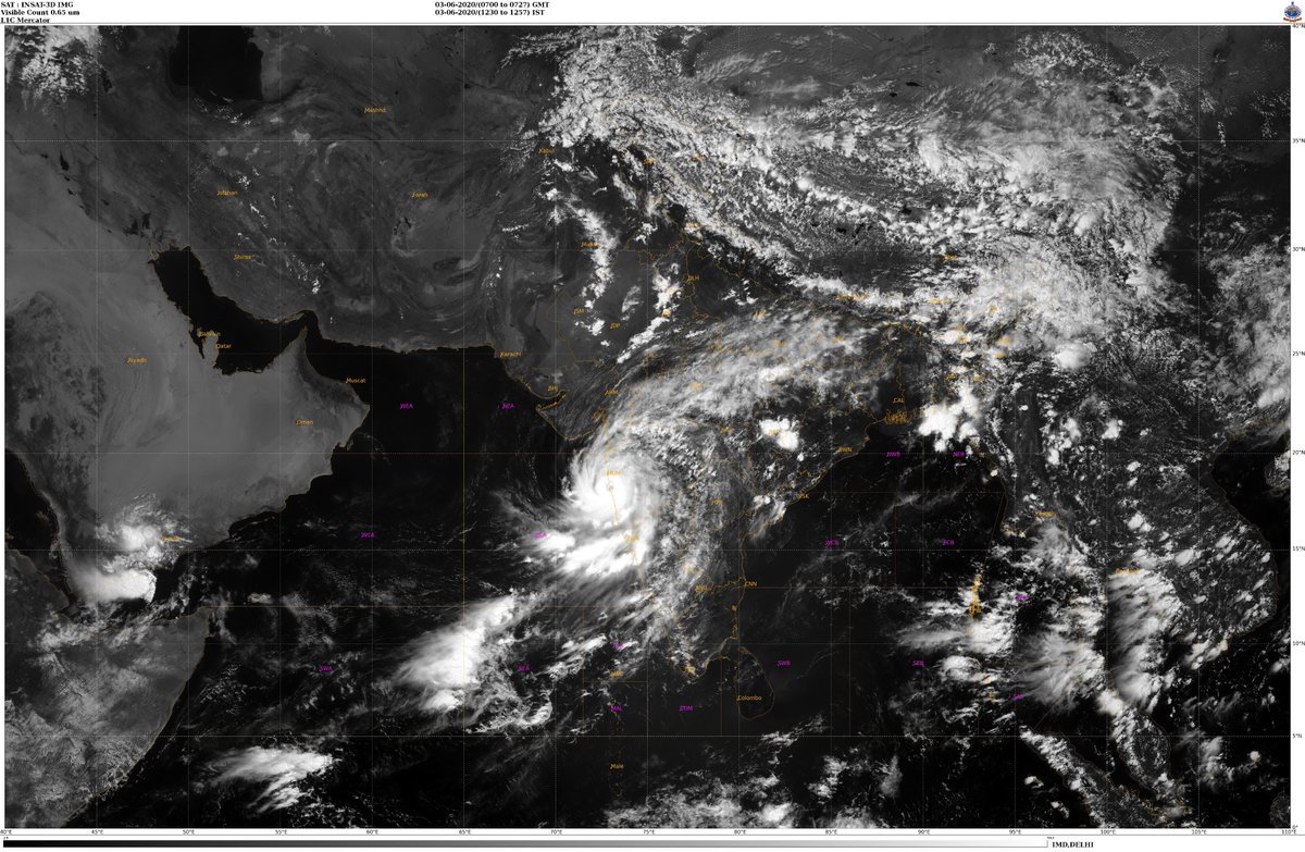
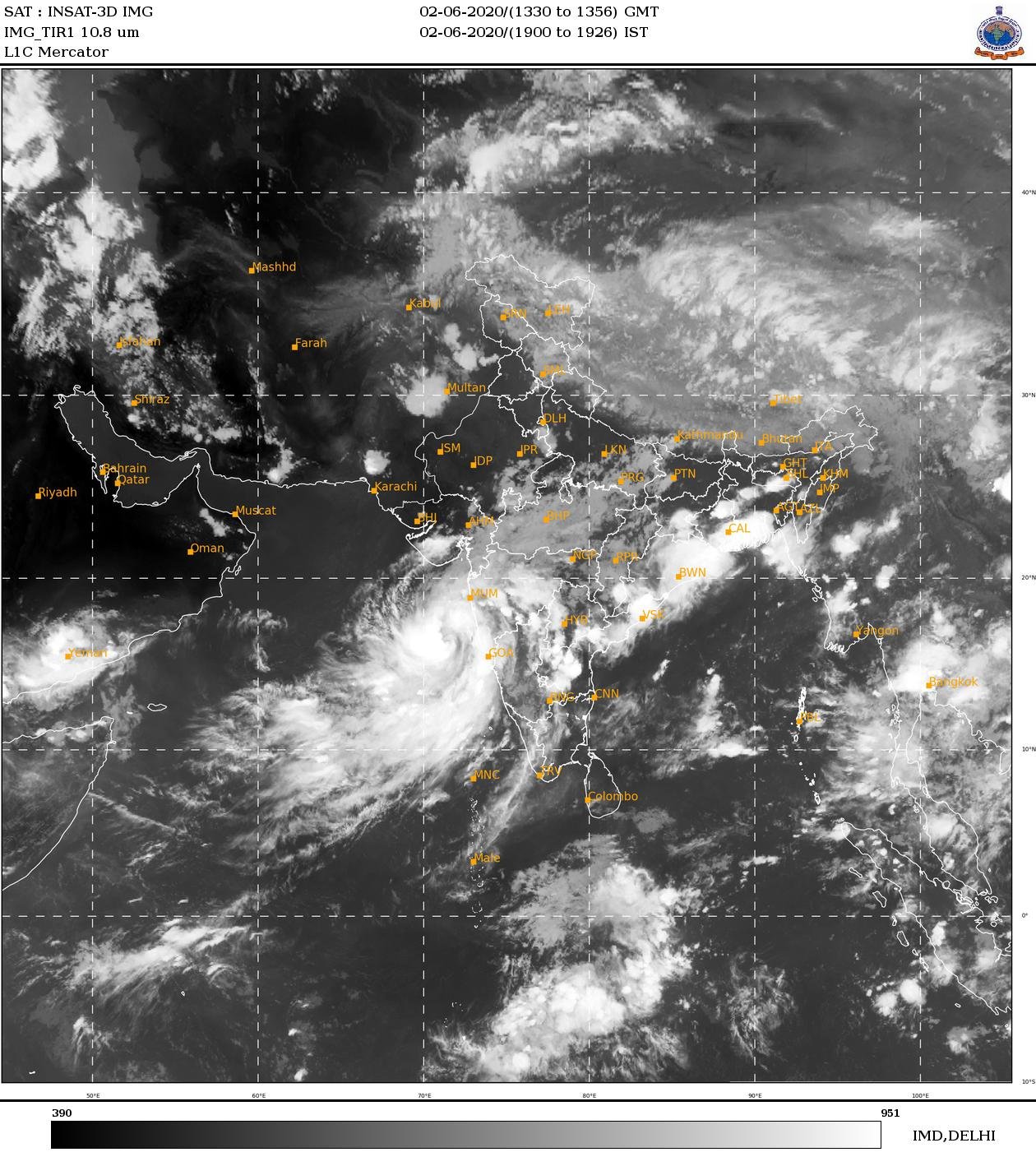
Bem, Nisarga foi um meio forte da categoria 1 que atingiu Mumbai, na India.
Agora o IMD classificar Nisarga como um Severe Cyclonic Storm.
De um minuto, Nisarga foi 85 mph, de acordo com a JTWC.
De tres minutos, Nisarga foi 65 mph, de acordo com o IMD.
E assim ficou Nisarga.
-
2
-
-
Voo de reconhecimento indica que Cristobal se intensificou um pouco.
BULLETIN
Tropical Storm Cristobal Intermediate Advisory Number 5A
NWS National Hurricane Center Miami FL       AL032020
700 PM CDT Tue Jun 02 2020

...RECONNAISSANCE AIRCRAFT FINDS CRISTOBAL A LITTLE STRONGER...
...HEAVY RAIN AND LIFE-THREATENING FLOODING THREAT CONTINUES...


SUMMARY OF 700 PM CDT...0000 UTC...INFORMATION
----------------------------------------------
LOCATION...19.1N 92.3W
ABOUT 50 MI...75 KM NW OF CIUDAD DEL CARMEN
MAXIMUM SUSTAINED WINDS...45 MPH...75 KM/H
PRESENT MOVEMENT...S OR 170 DEGREES AT 3 MPH...6 KM/H
MINIMUM CENTRAL PRESSURE...997 MB...29.44 INCHES


WATCHES AND WARNINGS
--------------------
CHANGES WITH THIS ADVISORY:

None.

SUMMARY OF WATCHES AND WARNINGS IN EFFECT:

A Tropical Storm Warning is in effect for...
* Campeche to Puerto de Veracruz

For storm information specific to your area, please monitor
products issued by your national meteorological service.


DISCUSSION AND OUTLOOK
----------------------
At 700 PM CDT (0000 UTC), the center of Tropical Storm Cristobal was
located near latitude 19.1 North, longitude 92.3 West.  Cristobal is
meandering generally southward near 3 mph (6 km/h), and a turn
toward the southeast and east is expected tonight and Wednesday,
followed by a turn toward the north-northeast and north on Thursday
night and Friday.  On the forecast track, the center will cross the
southern Bay of Campeche coast on Wednesday and move inland over
eastern Mexico Wednesday night and Thursday, and move back over the
Bay of Campeche Thursday night and Friday.

Data from an Air Force Reserve Hurricane Hunter reconnaissance
plane and surface observations indicate that the maximum sustained
winds have increased to near 45 mph (75 km/h) with higher gusts.
Some additional increase in strength is possible until the center
crosses the coast.  Gradual weakening is forecast while the center
remains inland, but restrengthening is expected after Cristobal
moves back over water Thursday night and Friday.

Tropical-storm-force winds extend outward up to 85 miles (140 km)
from the center.  An automated weather station on a Mexican offshore
platform recently measured a sustained wind of 48 mph with a gust to
62 mph.

The estimated minimum central pressure is 997 mb (29.44 inches).
-
2
-
-
23 minutos atrás, Rodolfo Alves disse:
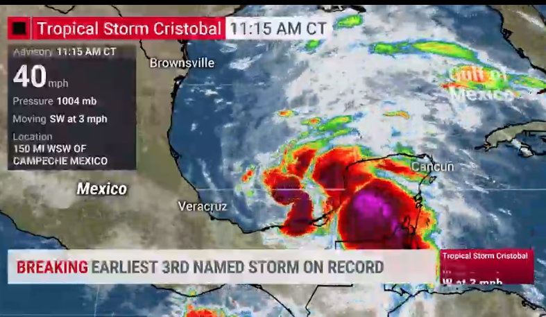
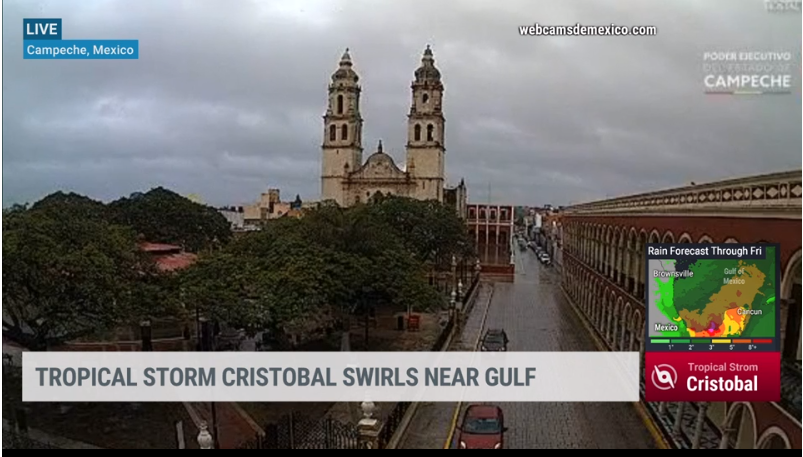
CRISTOBAL SE TORNA O 3º NOME MAIS PRECOCE DA HISTÓRIA DO ATLÂNTICO
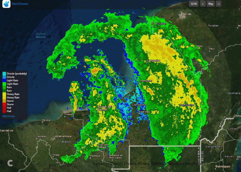
CAMPECHE COM O CÉU NUBLADO AGORA E NUVENS ESCURAS AO FUNDO
ÚLTIMA IMAGEM DO RADAR MEXICANO MOSTRA BANDAS DE CHUVA ASSOCIADAS A CRISTOBAL GIRANDO NA REGIÃO.
Eheheh 2005/2020 Atlantic hurricane seasons
-
1
-
-
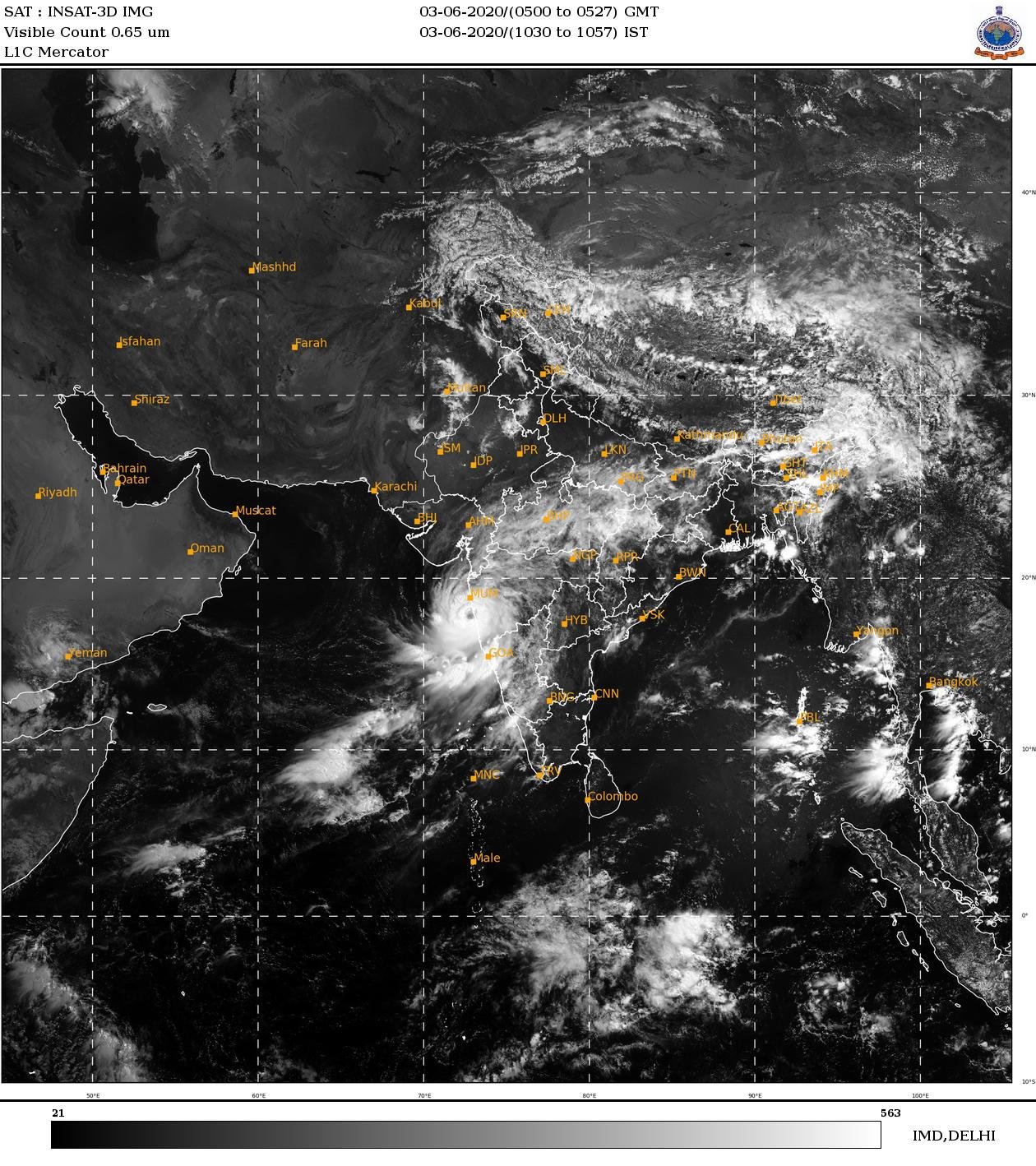
Hoje 93A é Nisarga.
É Cyclonic Storm pelo IMD.
Mas, pela JTWC ainda continua 93A. As intensidade mudou.
Intensidade de Nisarga estimada de 3-min pelo IMD: 35 kt, 40 mph ( 65 kmph ).
Intensidade de 1-min medida pela JTWC: 30 kt, 35 mph ( 55 kmph ).
Lembrando que Nisarga é o primeiro nome da nova lista para ciclones na bacia do indico norte.
REF/A/JOINT TYPHOON WRNCEN PEARL HARBOR HI/011351ZJUN2020//
AMPN/REF A IS A TROPICAL CYCLONE FORMATION ALERT//
RMKS/
1. FORMATION OF A SIGNIFICANT TROPICAL CYCLONE IS POSSIBLE WITHIN
120 NM EITHER SIDE OF A LINE FROM 15.6N 71.3E TO 19.1N 73.0E
WITHIN THE NEXT 12 TO 24 HOURS. AVAILABLE DATA DOES NOT JUSTIFY
ISSUANCE OF NUMBERED TROPICAL CYCLONE WARNINGS AT THIS TIME.
WINDS IN THE AREA ARE ESTIMATED TO BE 25 TO 30 KNOTS. METSAT
IMAGERY AT 021200Z INDICATES THAT A CIRCULATION CENTER IS LOCATED
NEAR 16.1N 71.5E. THE SYSTEM IS MOVING NORTH-NORTHEASTWARD AT 04
KNOTS.
2. REMARKS: THE AREA OF CONVECTION (INVEST 93A) PREVIOUSLY LOCATED
NEAR 13.5N 71.1E IS NOW LOCATED NEAR 16.1N 71.5E, APPROXIMATELY 185
NM SOUTHWEST OF MUMBAI, INDIA. ANIMATED ENHANCED INFRARED SATELLITE
IMAGERY AND A 021056Z 85GHZ SSMI MICROWAVE IMAGE DEPICT AN ELONGATED
AREA OF FLARING CONVECTION PARTIALLY OBSCURING A BROAD LOW LEVEL
CIRCULATION CENTER (LLCC). THE ENVIRONMENT IS MARGINAL FOR FURTHER
DEVELOPMENT, WITH MODERATE (15-20 KTS) VERTICAL WIND SHEAR OFFSET BY
WARM (29-30C) SEA SURFACE TEMPERATURES AND ESTABLISHED EQUATORWARD
OUTFLOW ALOFT. GLOBAL MODELS ARE IN AGREEMENT THAT INVEST 93A WILL
CONTINUE TO CONSOLIDATE INTO A TROPICAL CYCLONE OVER THE NEXT 24
HOURS AS IT TRACKS SLOWLY NORTHEASTWARD. MAXIMUM SUSTAINED SURFACE
WINDS ARE ESTIMATED AT 25 TO 30 KNOTS. MINIMUM SEA LEVEL PRESSURE IS
ESTIMATED TO BE NEAR 1000 MB. THE POTENTIAL FOR THE DEVELOPMENT OF A
SIGNIFICANT TROPICAL CYCLONE WITHIN THE NEXT 24 HOURS REMAINS HIGH.
THIS SUPERSEDES REF A.
3. THIS ALERT WILL BE REISSUED, UPGRADED TO WARNING OR CANCELLED BY
031400Z.//
NNNN
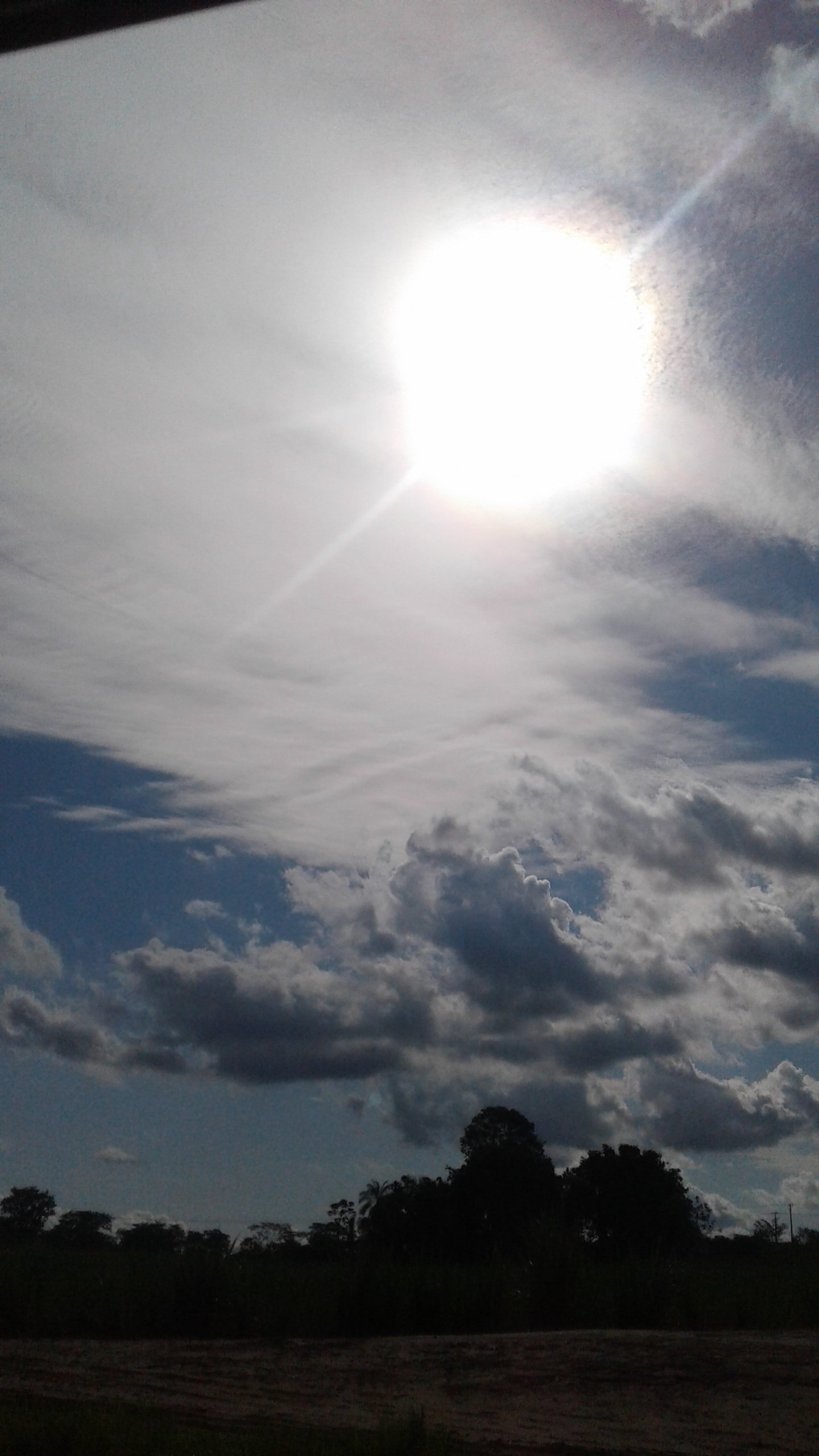
Está até que uma simetria bem organisada, não?
-
3
-
-
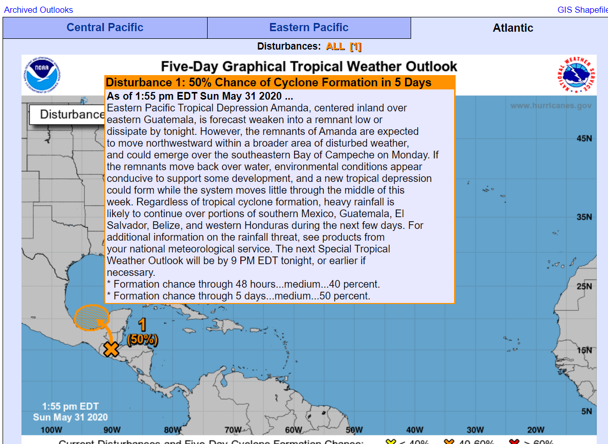
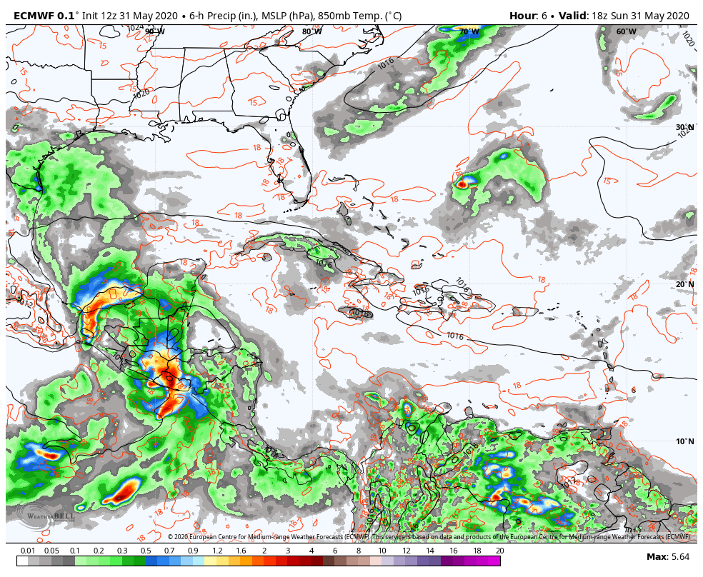
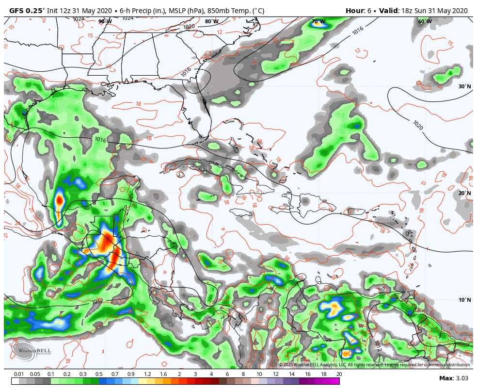
200 PM EDT Mon Jun 1 2020

For the North Atlantic...Caribbean Sea and the Gulf of Mexico:

1. Satellite imagery and radar observations from Mexico show that
the area of disturbed weather centered near the west coast of the
Yucatan peninsula is gradually becoming better organized.  The
disturbance will move west-northwestward over the Bay of Campeche
later this afternoon where environmental conditions are expected
to be conducive to support development, and a tropical depression
or storm is likely to form tonight or Tuesday.  The system is then
forecast to drift westward or west-southwestward over the southern
Bay of Campeche through the middle of the week.  Interests
along the coast of the Bay of Campeche should monitor the progress
of this disturbance as tropical storm watches or warnings could be
required for a portion of this area later today or tonight.
Regardless of tropical cyclone formation, heavy rainfall is likely
to continue over portions of southern Mexico, Guatemala, El
Salvador, Belize, and western Honduras during the next few days.
For additional information on the rainfall threat, see products
from your national meteorological service.
* Formation chance through 48 hours...high...90 percent.
* Formation chance through 5 days...high...90 percent.

Forecaster Brown
Forecaster Brown, valeu pela atualização😉
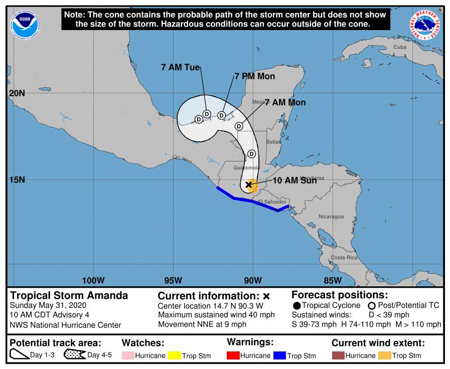
91E (Amanda) deve virar TD ou TS ainda essa noite.
-
1
-
-
2 horas atrás, Rodolfo Alves disse:
NHC DANDO 50% DE CHANCES NESTE MOMENTO PARA O REDESENVOLVIMENTO DE AMANDA NO GOLFO DO MÉXICO.... COMO JÁ DITO, SE ISSO OCORRER, O CICLONE TROPICAL SERÁ CHAMADO DE "CRISTOBAL".
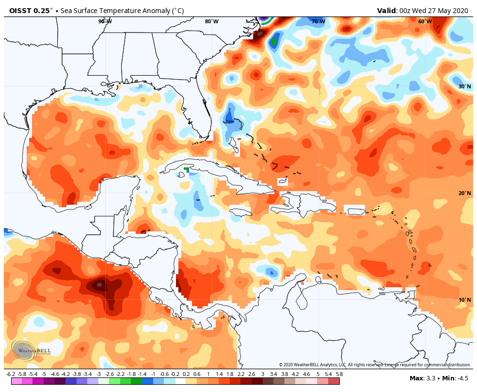
AO ENTRAR NO GOLFO DO MÉXICO A CIRCULAÇÃO REMANESCENTE DE AMANDA IRÁ ENCONTRAR UM AMBIENTE FAVORÁVEL COM SST ACIMA DA MÉDIA. EU DIRIA QUE É ALTA A CHANCE DE CRISTOBAL SE FORMAR EM ALGUM PONTO DESTA SEMANA.
TANTO ECMWF, QUANTO O GFS, EM SOLUÇÕES DESTA TARDE APONTAM O DESENVOLVIMENTO DE CRISTOBAL COM AMEAÇA DE LANDFALL NA COSTA AMERICANA.
Sera q se descarta a possibilidade do possivel Cristobal virar um Furacão?
-
1
-
-
42 minutos atrás, PabloMartins disse:
Vim trazer uma curiosidade e coincidência. A tempestade tropical Amanda, está localizada em um local parecido com sua "antepassada" de 2008 e na mesma época.
Em 29 de Maio de 2008 formou-se a Tempestade Tropical Alma no Oeste do litoral da Costa Rica e fez landfall em León, Nicaragua no fim do mesmo dia que se formou, mas como uma forte tempestade tropical. Alma causou a morte de 11 pessoas e causou 35 milhões de dólares em prejuízos, com severas inundações e alagamentos. O NHC retirou o nome de Alma e substitui por Amanda, que fez história em 2014 e agora repete uma história parecida com sua "antepassada" de 12 anos atrás.
Lembrando que Alma em 2008 ajudou a formar Arthur no Atlântico poucas horas depois; E agora estamos vendo uma forte possibilidade de Amanda se tornar Cristobal no Atlântico em um perigoso CAG (Central American Gyre). Já foi confirmado que 6 pessoas morreram por enchentes rápidas e 1 morte foi confirmada por causa de desabamento de casas.
Agora so falta o nome Amanda ser retirado.
Arthur e Amanda tem planos de afetar sempre a mesma localidade, so pode meu Deus...
-
1
-
-
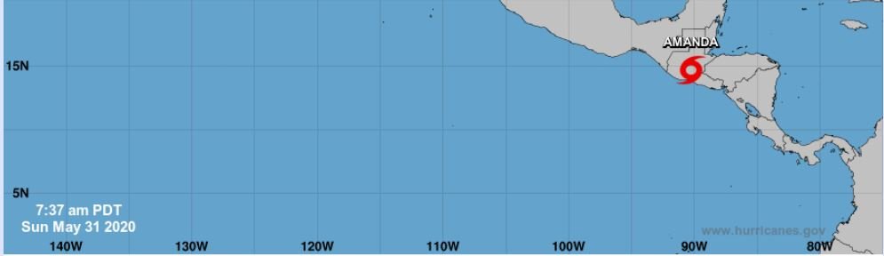
Two E finalmente foi nomeado Amanda.
O sistema está sobre terra e deve chegar ao méxicoem menos de 10 h
Por mim, acho que os remanecentes da TS tem uma chance condicional de se regenerar novamente.
-
3
-
-
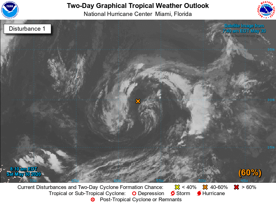
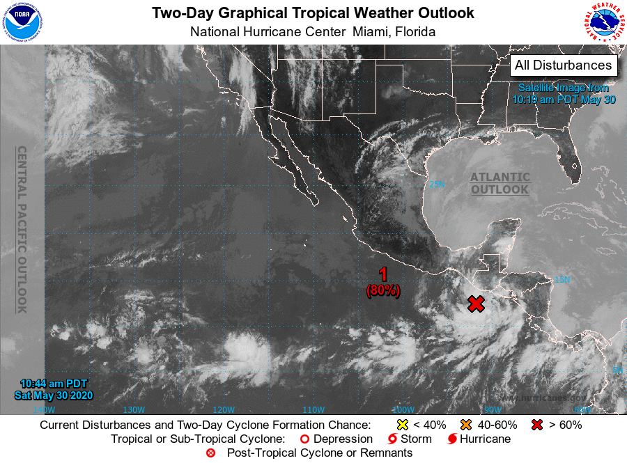
91E agora e Two-E.
Deve virar TS e tocar terra em mens de 20 h.
BULLETIN
Tropical Depression Two-E Advisory Number   1
NWS National Hurricane Center Miami FL       EP022020
400 PM CDT Sat May 30 2020

...TROPICAL DEPRESSION FORMS NEAR THE COASTS OF EL SALVADOR AND
GUATEMALA...
...HEAVY RAINFALL IS THE PRIMARY THREAT...


SUMMARY OF 400 PM CDT...2100 UTC...INFORMATION
----------------------------------------------
LOCATION...12.3N 91.1W
ABOUT 110 MI...180 KM S OF PUERTO SAN JOSE GUATEMALA
MAXIMUM SUSTAINED WINDS...30 MPH...45 KM/H
PRESENT MOVEMENT...NNE OR 30 DEGREES AT 3 MPH...6 KM/H
MINIMUM CENTRAL PRESSURE...1006 MB...29.71 INCHES


WATCHES AND WARNINGS
--------------------
CHANGES WITH THIS ADVISORY:

The government of El Salvador has issued a Tropical Storm Warning
for the entire coast of El Salvador, from the Guatemala/El Salvador
border to the El Salvador/Honduras border.

The government of Guatemala has issued a Tropical Storm Warning for
the entire coastline of Guatemala, from the Mexico/Guatemala border
eastward to the Guatemala/El Salvador border.

SUMMARY OF WATCHES AND WARNINGS IN EFFECT:

A Tropical Storm Warning is in effect for...
* Entire coast of El Salvador
* Entire coast of Guatemala

A Tropical Storm Warning means that tropical storm conditions are
expected somewhere within the warning area, in this case within the
next 12 to 24 hours.

Interests in southern Mexico and Honduras should monitor the
progress of this system.

For storm information specific to your area, please monitor
products issued by your national meteorological service.


DISCUSSION AND OUTLOOK
----------------------
At 400 PM CDT (2100 UTC), the center of Tropical Depression Two-E
was located near latitude 12.3 North, longitude 91.1 West. The
depression is moving toward the north-northeast near 3 mph (6
km/h), and a slow north or north-northeast motion is expected until
landfall.  On the forecast track, the center of the depression is
expected to cross the coast of Guatemala tonight or early Sunday.

Maximum sustained winds are near 30 mph (45 km/h) with higher gusts.
Some strengthening is possible until the system makes landfall.
Dissipation is expected shortly after the system moves inland.

The estimated minimum central pressure is 1006 mb (29.71 inches).


HAZARDS AFFECTING LAND
----------------------
RAINFALL:  The depression is expected to produce total rain
accumulations of 10 to 15 inches over El Salvador, southern
Guatemala, and western Honduras, and 5 to 10 inches over northwest
Nicaragua, Belize, and the Mexican states of Chiapas, Tabasco,
Veracruz, and Oaxaca.  Isolated maximum amounts of 20 inches are
possible in El Salvador and southern Guatemala.  This rainfall may
produce life-threatening flash floods and mudslides.

WIND:  Tropical storm conditions are expected within the warning
area tonight and early Sunday.


NEXT ADVISORY
-------------
Next intermediate advisory at 700 PM CDT.
Next complete advisory at 1000 PM CDT.
-
3
-
-
91E ganhou força agora.
NHC diz que o sistema tem 80% de virar algo nos prox 5 dias e 48h.
Acho que vira TD hojea noite e TS amanha a tarde.
A temp. de furacões no ATL abre oficialmente depois de amanhã, com a possível formação de Cristobal já no começo de tudo.
P.S. editei p falar que 92L agora so tem 40% de chances de se formar, devido a alguns fatores que faz todos os ciclones tropicais perderem força.
Tropical Weather Outlook
NWS National Hurricane Center Miami FL
1100 AM PDT Sat May 30 2020

For the eastern North Pacific...east of 140 degrees west longitude:

1. Satellite images indicate that showers and thunderstorms associated
with the low pressure system located just off the coasts of
Guatemala and El Salvador continue to become better organized.  If
the current trend continues, advisories could be initiated on this
system later today or tonight. Interests in El Salvador, Guatemala,
and southern Mexico should closely monitor the progress of this
system as it is expected to move across those locations tonight and
Sunday.

Regardless of development, this slow moving disturbance is expected
to produce heavy rainfall over portions of Central America and
southern Mexico during the next few days.  These rains could cause
life-threatening flash floods and mudslides, especially in areas of
mountainous terrain.  See products from your local national
meteorological service for additional information.
* Formation chance through 48 hours...high...80 percent.
* Formation chance through 5 days...high...80 percent.

Forecaster Cangialosi
-
4
-
-
Agenda da JTWC hoje foi dar 2 TCFA. O 1° foi para 91E e o segundo para 92A.
A agencia estima a mesma intensidade para os dois, ambos com 25 kn (30 mph).
92A agora é ARB 01 pelo IMD e está mediando mar e terra em Oman.
-
1
-
-
2 horas atrás, Felipe F disse:
Oi?
Nem imaginava isso. Achei que seria apenas chance baixa, pois vi que as condições não eram boas.
Já foram 3 areas designadas no atlântico, e dessas 3 se formaram 2 (Arthur e Bertha),
será que o atlântico está dando sinal de extrema atividade ciclônica? Deus me livre!
-
1
-
-
92A agora tem seu lugar no mundo.
O sistema está bem próximo de Salalah, em Oman.
Agora a JTWC diz que a chance é média.
O IMD guardou a tempestade como LPA.
Os ventos não mudaram. 25 knots. A pressão é 1004.
Maio não vai ser tããão inativo como quase sempre foi, caso 91E e 92A se formem.
-
- A TS Bertha virou TD Bertha, já que agora está meio que completamente em terra firme. Está causando muita chuva por onde passa e seus remanecentes deve ser absorvidos por algum sistema frontal (minha previsão).
- 91E agora tem 30% de virar depressão ou tempestade tropical nas prox 48 hrs, enquanto tem 80% de chance de virar TD ou TS nos prox 5 dias. O sistema causa muitas chuvas em partes da América Central.
- O NHC informou que tem uma onda tropical ao lado das bandas de 91E causando tambem chuvas e ventos fortes. Minha previsão é que essa onda vire um possível TS ou HU Cristobal na primeira semana de Junho. Acho que tem alguma chance de virar talvez um major hurricane. So que como um cat 3 mínimo.
TROPICAL WAVES
A tropical wave is along 62W from 19N southward and is moving W
at 15-20 kt. TPW imagery has been showing enhanced moisture east
of the wave. No significant convection is associated with this
wave.

A Caribbean Sea tropical wave is along 88W from 22N southward
and is moving W at 10 kt. Scattered moderate convection is noted
in the Gulf of Honduras, E of 85W.
-
2
-
Tem uma pequena area de convecção no sul de Oman, e a JTWC propôs que a tempestade tem chance baixa de virar alguma coisa daqui pra frente.
O sistema foi designado como 92A e tem ventos de 30 mph e pressão de 1005 mb.
SUBJ/SIGNIFICANT TROPICAL WEATHER ADVISORY FOR THE INDIAN OCEAN /REISSUED/271330Z-271800ZMAY2020// RMKS/ 1. NORTH INDIAN OCEAN AREA (MALAY PENINSULA WEST TO COAST OF AFRICA): A. TROPICAL CYCLONE SUMMARY: NONE. B. TROPICAL DISTURBANCE SUMMARY: (1) AN AREA OF CONVECTION (INVEST 92A) HAS PERSISTED NEAR 15.0N 55.5E, APPROXIMATELY 146 NM SOUTHEAST OF SALALAH, OMAN. ANIMATED VISIBLE SATELLITE IMAGERY AND A 270911Z AMSR2 89GHZ MICROWAVE IMAGE DEPICT A COMPACT LOW LEVEL CIRCULATION WITH PERSISTENT CONVECTION AND STRONG MID-LEVEL TURNING. A 270448Z METOP- A ASCAT IMAGE FURTHER INDICATES A WEAK CIRCULATION EMBEDDED WITHIN A SHARP TROUGH WITH 20-25KT SOUTHWESTERLY SURGE WINDS. UPPER-LEVEL ANALYSIS INDICATES A FAVORABLE ENVIRONMENT WITH LOW TO MODERATE (10- 20 KNOT) VWS, GOOD EQUATORWARD OUTFLOW AND WARM SST (29-30C). GLOBAL MODELS ARE IN GOOD AGREEMENT ON FURTHER DEVELOPMENT OF THIS SYSTEM WITH A SLOW NORTHWESTWARD TRACK, EXCEPT UKMET WHICH HAS THE SYSTEM TRACKING NORTH-NORTHEASTWARD. MAXIMUM SUSTAINED SURFACE WINDS ARE ESTIMATED AT 20 TO 25 KNOTS. MINIMUM SEA LEVEL PRESSURE IS ESTIMATED TO BE NEAR 1005 MB. THE POTENTIAL FOR THE DEVELOPMENT OF A SIGNIFICANT TROPICAL CYCLONE WITHIN THE NEXT 24 HOURS IS LOW. -
Em 24/05/2020 em 02:53, Rodolfo Alves disse:
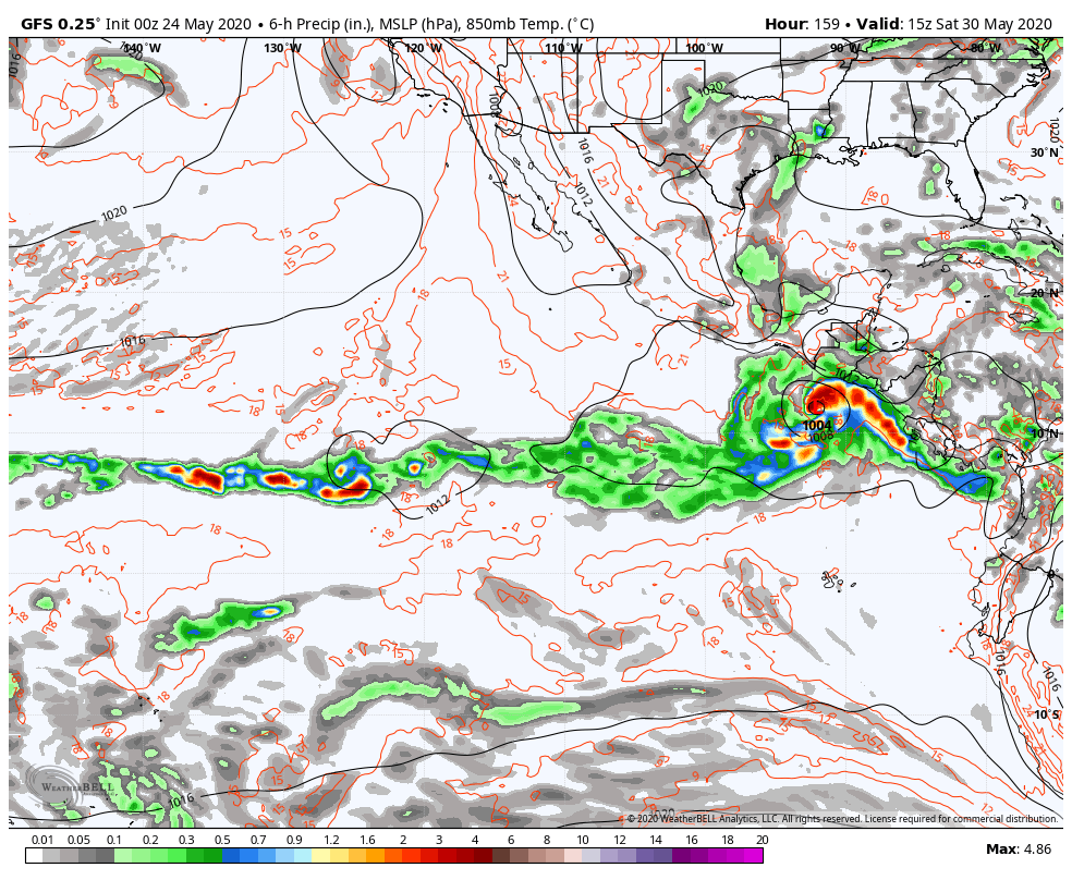
GFS E ECMWF COMEÇAM A INDICAR O QUE PODERÁ SER O PRIMEIRO SISTEMA APÓS O COMEÇO OFICIAL DA TEMPORADA NO PACÍFICO LESTE.
A FORMAÇÃO PODERÁ OCORRER ENTRE FIM DE MAIO E O COMEÇO DE JUNHO.
SAÍDA DESTA MADRUGADA DO GFS (0Z) SUGERE A FORMAÇÃO DE UM SISTEMA TROPICAL NA COSTA GUATEMALA POR VOLTA DO DIA 30, COM LANDFALL NESTE MESMO PAÍS.
MAIS CEDO, A 12Z DO ECMWF INDICAVA A MESMA BAIXA, PORÉM UM POUCO MAIS A OESTE, EM DIREÇÃO AO MÉXICO E COM FORMAÇÃO UM POUCO MAIS TARDIA.
A ASSISTIR....
Falando nisso, até o NHC já está esperando se formar onde tais modelos como os citados, já lembrando que as chances de se formar alguma coisa no Pacífico Leste pelo NHC de 48 hrs está pratimente nenhuma. Mas, nos próx cinco(5) dias é meio que alto. Aparece média a cor, mas a chance é compativel com alta. São 60 ou 50% de chances.
No atlântico tem uma area que em cima da terra da flórida, mas provavelmente não fará nada, pois o NHC diz que as condições não são das boas. O sistema de atingir a geógia e as carolinas já sem nada.
-
 1
1
-
-
Bem, então o mundo decidiu que vai silenciar os ciclones no mundo por um certo tempo.
O mundo está quieto desde a dissipação do Ciclone Mangga. Mas agora os olhos viram um pouquinho para o Pacífico Oeste, pois a PAGASA retirou o nome Ambo de sua lista rotatória de interesses filipinos nos Tufões. E isso não acontece há anos com os nomes de letra A pela PAGASA, lembrando que é só o segundo tufão/tempestade tropical retirado com a letra A. O nome Vongfong agora é assunto pra Organisação Mundial da Meteorologia resolver.
-
1
-
-
Ciclone Mangga se formou a bacia austráliana.
Não deve afetar nenhuma localidade.
-
2
-


Tufões no Pacífico Oeste - 2020
in Monitoramento de Furacões, Tufões e Ciclones Tropicais
Posted · Edited by Miguel Russe
------------------------------------------------------------------------------------------------------------------------------------------
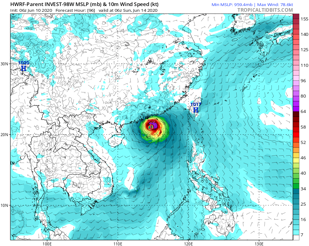
HWRF esta com sangue nos olhos mediante a China e o Novo Coronavírus.
HWRF Deve falar em um forte categoria 4, com pressão minima de 953 mbar !!!