

Miguel Russe
-
Posts
777 -
Joined
-
Last visited
Content Type
Profiles
Forums
Gallery
Calendar
Everything posted by Miguel Russe
-
 Quantidade de planos meus para 2020/como está sendo meu 2020
 -
Fui passear na wikipedia e achei uma coincidência Hurricane Hanna (2008)Edit Category 1 hurricane (SSHWS) Duration August 28 – September 7 Peak intensity 85 mph (140 km/h) (1-min) 977 mbar (hPa) Hanna 2020: Hurricane Hanna Current storm status Category 1 hurricane (1-min mean) Satellite image Forecast map As of: 10:00 a.m. CDT (15:00 UTC) July 25 Location: 27.1°N 96.3°W ± 20 nm About 75 mi (120 km) ENE of Port Mansfield, Texas About 85 mi (135 km) SE of Corpus Christi, Texas Sustained winds: 75 kt (85 mph; 140 km/h) (1-min mean) gusting to 85 kt (100 mph; 155 km/h) Pressure: 973 mbar (hPa) Movement: ~~~~~~~~~~~~~~~~~~~~~~~~~~ Coincidências: Hanna 2008 e Hanna 2020 ----------| Hanna 2008: fez landfall nos EUA. Hanna 2020: Também! ----------| Hanna 2008: teve pico de categoria 1 e ventos de 85 mph. Hanna 2020: Também! ----------| Hanna 2008: Matou pessoas. Hanna 2020: Também... ----------| Hanna 2008: Fez parte de uma temporada ativa. Hanna 2020: Também! (Eu acho....) ----------| Hanna 2008: Se formou e se dissipou em final de algum mês. Hanna 2008: Também! ----------| W at 6 kt (7 mph; 11 km/h)
-
92L Tropical Weather Outlook NWS National Hurricane Center Miami FL 200 PM EDT Sat Jul 25 2020 For the North Atlantic...Caribbean Sea and the Gulf of Mexico: The National Hurricane Center is issuing advisories on Tropical Depression Gonzalo, located just of northwest of Trinidad. The National Hurricane Center is also issuing advisories on Hurricane Hanna, located over the western Gulf of Mexico just offshore the southern coast of Texas. 1. A tropical wave is producing a broad area of cloudiness and disorganized showers and thunderstorms several hundred miles southwest of Cabo Verde Islands. The wave is expected to move westward at about 15 mph during the next several days, and a tropical depression is likely form early next week when the system reaches the central tropical Atlantic. * Formation chance through 48 hours...low...20 percent. * Formation chance through 5 days...high...70 percent.
-
MAKING LANDFALL
-
Gonzalo virou depressão tropical. BULLETIN Tropical Depression Gonzalo Intermediate Advisory Number 16A NWS National Hurricane Center Miami FL AL072020 200 PM AST Sat Jul 25 2020 ...SQUALLS OF GONZALO SPREADING ACROSS THE FAR SOUTHEASTERN CARIBBEAN SEA... SUMMARY OF 200 PM AST...1800 UTC...INFORMATION ---------------------------------------------- LOCATION...10.8N 61.9W ABOUT 50 MI...80 KM NW OF TRINIDAD MAXIMUM SUSTAINED WINDS...35 MPH...55 KM/H PRESENT MOVEMENT...W OR 275 DEGREES AT 20 MPH...32 KM/H MINIMUM CENTRAL PRESSURE...1010 MB...29.82 INCHES
-
Acho que não.
-
Furacão Hanna
-
Barry 2019 Hanna 2020
-
Barry 2.0
-
NHC dando agora 60% de chances para 92L evoluir em TD 09-L ou TS Aizéa (Isaias). Tropical Weather Outlook NWS National Hurricane Center Miami FL 800 AM EDT Sat Jul 25 2020 For the North Atlantic...Caribbean Sea and the Gulf of Mexico: The National Hurricane Center is issuing advisories on Tropical Storm Gonzalo, located about 100 miles east of Trinidad. The National Hurricane Center is also issuing advisories on recently upgraded Hurricane Hanna, located over the western Gulf of Mexico near the southeast coast of Texas. 1. A tropical wave is producing an area of disorganized showers and thunderstorms a few hundred miles southwest of Cabo Verde Islands. The wave is expected to move westward at about 15 mph during the next several days, and a tropical depression could form by early next week when the system reaches the western tropical Atlantic. * Formation chance through 48 hours...low...10 percent. * Formation chance through 5 days...medium...60 percent.
-
Pra que a pressão tão baixa? Se é pra ser assim, atualizava Hanna pra categoria 2!
-
Hanna gerou um olho pinhole. Deve virar furacão na proxima atualização.
-
Mas as chances de Hanna se intensificar está nas mãos dos avisos intermediatos do NHC.
-
CPHC vai enviar um Voo de reconhecimento para Douglas. AF301 Mission #1 into DOUGLAS Type: Unknown | Status: In Progress As of 01:49 UTC Jul 25, 2020: Aircraft Position: 21.32°N 158.08°W Bearing: 90° at 0 kt Altitude: 18 gpm Peak 10-second Wind: 0 kt at 0° Extrapolated Sea-level Pressure: 1016.0 mb Aircraft Data Time Series (click to enlarge): Raw data file Full Mission In-Storm (click to enlarge): Raw data file Latest 10 Minutes of Obs (click to enlarge): Raw data file Dropsonde Locations and IDs (click to enlarge):
-
Voo de reconhecimento encontrou ha pouquissimo tempo em Hanna ventos de 67 kt
-
O modelo MIG-RUSSE na ultima rodada mostra landfall no TX com pressão minima de 969 mbar e 115 mph.
-
Quais problemas?
-
HWRF-Parent tranformando Hanna de Bike em um Monster Truck.
-
Alguém concorda com a estmativa do CPHC de afimar que Douglas tem 115 mph?
-
Hanna tem chances de se tornar furacão, como disse @Felipe F e o NHC. BULLETIN Tropical Storm Hanna Advisory Number 8 NWS National Hurricane Center Miami FL AL082020 400 PM CDT Fri Jul 24 2020 ...HANNA GETTING BETTER ORGANIZED OVER THE WESTERN GULF OF MEXICO... ...HURRICANE AND STORM SURGE WARNINGS ISSUED FOR PORTIONS OF THE CENTRAL TEXAS COAST... SUMMARY OF 400 PM CDT...2100 UTC...INFORMATION ---------------------------------------------- LOCATION...27.3N 94.3W ABOUT 195 MI...310 KM E OF CORPUS CHRISTI TEXAS ABOUT 195 MI...315 KM ENE OF PORT MANSFIELD TEXAS MAXIMUM SUSTAINED WINDS...50 MPH...85 KM/H PRESENT MOVEMENT...W OR 275 DEGREES AT 10 MPH...17 KM/H MINIMUM CENTRAL PRESSURE...999 MB...29.50 INCHES WATCHES AND WARNINGS -------------------- CHANGES WITH THIS ADVISORY: A Hurricane Warning has been issued from Baffin Bay northward to Mesquite Bay, Texas. A Storm Surge Warning has been issued from Baffin Bay to Sargent, Texas, including Corpus Christi Bay, Copano Bay, Aransas Bay, San Antonio Bay and Matagorda Bay. SUMMARY OF WATCHES AND WARNINGS IN EFFECT: A Storm Surge Warning is in effect for... * Baffin Bay to Sargent Texas A Hurricane Warning is in effect for... * Baffin Bay to Mesquite Bay Texas A Tropical Storm Warning is in effect for... * Mouth of the Rio Grande to Baffin Bay Texas * Mesquite Bay to San Luis Pass Texas A Storm Surge Warning means there is a danger of life-threatening inundation, from rising water moving inland from the coastline, during the next 24 hours in the indicated locations. For a depiction of areas at risk, please see the National Weather Service Storm Surge Watch/Warning Graphic, available at hurricanes.gov. This is a life-threatening situation. Persons located within these areas should take all necessary actions to protect life and property from rising water and the potential for other dangerous conditions. Promptly follow evacuation and other instructions from local officials. A Hurricane Warning means that hurricane conditions are expected somewhere within the warning area, in this case within the next 24 hours. Preparations to protect life and property should be rushed to completion. A Tropical Storm Warning means that tropical storm conditions are expected somewhere within the warning area, in this case within the next 24 hours. Interests elsewhere along the Texas and Louisiana coasts should monitor the progress of Hanna. For storm information specific to your area, including possible inland watches and warnings, please monitor products issued by your local National Weather Service forecast office. DISCUSSION AND OUTLOOK ---------------------- At 400 PM CDT (2100 UTC), the center of Tropical Storm Hanna was located near latitude 27.3 North, longitude 94.3 West. Hanna is moving toward the west near 10 mph (17 km/h), and this motion should continue through Saturday morning. A gradual turn toward the west-southwest is expected Saturday night and that motion should continue through Sunday. On the forecast track, center of Hanna should make landfall along the Texas coast within the hurricane warning area Saturday afternoon or early evening. Maximum sustained winds are near 50 mph (85 km/h) with higher gusts. Steady strengthening is forecast for the next 24 hours, and Hanna is expected to become a hurricane before the cyclone makes landfall. Steady to rapid weakening is expected after Hanna moves inland. Tropical-storm-force winds extend outward up to 60 miles (95 km) from the center. The estimated minimum central pressure is 999 mb (29.50 inches) based on nearby oil rig reports. HAZARDS AFFECTING LAND ---------------------- Key messages for Hanna can be found in the Tropical Cyclone Discussion under AWIPS header MIATCDAT3 and WMO header WTNT43 KNHC. STORM SURGE: The combination of a dangerous storm surge and the tide will cause normally dry areas near the coast to be flooded by rising waters moving inland from the shoreline. The water could reach the following heights above ground somewhere in the indicated areas if the peak surge occurs at the time of high tide... Baffin Bay to Sargent TX...including Corpus Christi Bay, Copano Bay, Aransas Bay, San Antonio Bay, and Matagorda Bay...2 to 4 ft Mouth of the Rio Grande to Baffin Bay TX...1 to 3 ft North of Sargent to High Island TX...including Galveston Bay...1 to 2 ft The deepest water will occur along the immediate coast near and to the right of the landfall location. Surge-related flooding depends on the relative timing of the surge and the tidal cycle, and can vary greatly over short distances. For information specific to your area, please see products issued by your local National Weather Service forecast office. WIND: Hurricane conditions are expected in the warning area Saturday afternoon. Tropical storm conditions are expected to begin in the warning area tonight or Saturday morning. RAINFALL: Hanna is expected to produce 5 to 10 inches of rain with isolated maximum totals of 15 inches through Sunday night in south Texas and into the Mexican states of Coahuila, Nuevo Leon, and northern Tamaulipas. This rain may result in life-threatening flash flooding, rapid rises on small streams, and isolated minor to moderate river flooding in south Texas. 3 to 5 inches of rain is expected along the upper Texas and Louisiana coasts. SURF: Swells generated by Hanna are expected to increase and affect much of the Texas and Louisiana coasts during the next few days. These swells are likely to cause life-threatening surf and rip current conditions. Please consult products from your local weather office. TORNADOES: A brief tornado or two will be possible, mainly overnight, across portions of the upper Texas and Louisiana Coasts.
-
Eu vou seguir o caminho do EURO. Hurricane Isaias: 160 mph and 928 mbar. (Obs: não fiquem estranhando essa previsão, isso e pq gosto de ser exagerado rs)
-
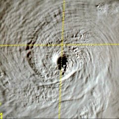
Após completar agora no inicio da tarde um ciclo de substituição da parede do olho, o Furacão Douglas tem algumas características anulares. O olho também está 90% limpo e dando algumas chineladas no ar seco agora. olhando nas imagens de satelite, Douglas deu intensificada, contrariando ¼ das palavras que o @PabloMartins disse. MAS, ainda sim Douglas uma hora ou outra vai perder força.
-
Hanna ganhou um olho de médio nivel. Além disso, agora tem 50 mph 999 mbar de intensidade, segundo o NHC. Tropical Storm Hanna Discussion Number 7 NWS National Hurricane Center Miami FL AL082020 1000 AM CDT Fri Jul 24 2020 Reports from a NOAA reconnaissance aircraft this morning and nearby ship D5DY4 indicate that Hanna has strengthened a little. However, the aircraft data also showed that Hanna's center had moved or reformed a little farther north near the northern edge of the convective cloud mass. A partial SSMI/S pass around 1231Z suggested that a mid-level eye feature could be forming, but it also possible that a dry slot may be intruding into the cloud shield from the northwest and west. The initial intensity of 40 kt is based on aircraft SFMR surface winds of 38-40 kt, and the 1200Z D5DY5 ship report of 48 kt at 89 meters elevation, which reduces to a 38-kt 10-meter wind speed. BULLETIN Tropical Storm Hanna Intermediate Advisory Number 7A NWS National Hurricane Center Miami FL AL082020 100 PM CDT Fri Jul 24 2020 ...HANNA CONTINUES TO STRENGTHEN OVER THE WESTERN GULF OF MEXICO... SUMMARY OF 100 PM CDT...1800 UTC...INFORMATION ---------------------------------------------- LOCATION...27.3N 93.7W ABOUT 230 MI...375 KM E OF CORPUS CHRISTI TEXAS ABOUT 230 MI...375 KM E OF PORT MANSFIELD TEXAS MAXIMUM SUSTAINED WINDS...50 MPH...85 KM/H PRESENT MOVEMENT...WNW OR 285 DEGREES AT 9 MPH...15 KM/H MINIMUM CENTRAL PRESSURE...999 MB...29.50 INCHES WATCHES AND WARNINGS -------------------- CHANGES WITH THIS ADVISORY: None. SUMMARY OF WATCHES AND WARNINGS IN EFFECT: A Tropical Storm Warning is in effect for... * Mouth of the Rio Grande to San Luis Pass Texas A Tropical Storm Warning means that tropical storm conditions are expected somewhere within the warning area, in this case within 24 to 36 hours. Interests along the Texas and Louisiana coast should monitor the progress of this system. For storm information specific to your area, including possible inland watches and warnings, please monitor products issued by your local National Weather Service forecast office. DISCUSSION AND OUTLOOK ---------------------- At 100 PM CDT (1800 UTC), the center of Tropical Storm Hanna was located by satellite and NOAA Doppler weather radars near latitude 27.3 North, longitude 93.7 West. Hanna is moving toward the west-northwest near 9 mph (15 km/h), and this motion should continue this afternoon. A turn toward the west is expected tonight, followed by a westward to west-southwestward motion through the weekend. On the forecast track, center of Hanna should make landfall along the Texas coast within the warning area Saturday afternoon or evening. Maximum sustained winds have increased to near 50 mph (85 km/h) with higher gusts. Additional strengthening is expected until the tropical cyclone makes landfall. Steady weakening is expected after Hanna moves inland. Tropical-storm-force winds extend outward up to 60 miles (95 km) from the center. During the past couple of hours, a ship located just east of the center reported a sustained wind of 46 mph (74 km/h). The estimated minimum central pressure is 999 mb (29.50 inches). HAZARDS AFFECTING LAND ---------------------- Key messages for Tropical Storm Hanna can be found in the Tropical Cyclone Discussion under AWIPS header MIATCDAT3 and WMO header WTNT43 KNHC. WIND: Tropical storm conditions are expected in the warning area by tonight or Saturday morning. RAINFALL: Hanna is expected to produce 4 to 8 inches of rain with isolated maximum totals of 12 inches through Sunday night in south Texas. This rain may result in life-threatening flash flooding, rapid rises on small streams, and isolated minor to moderate river flooding in south Texas. 3 to 5 inches of rain is expected along the upper Texas and Louisiana coasts, and inland to the Mexican states of Coahuila, Nuevo Leon, and northern Tamaulipas. STORM SURGE: The combination of storm surge and the tide will cause normally dry areas near the coast to be flooded by rising waters moving inland from the shoreline. The water could reach the following heights above ground somewhere in the indicated areas if the peak surge occurs at the time of high tide... Mouth of the Rio Grande to High Island including Corpus Christi Bay, Matagorda Bay, and Galveston Bay...1-3 ft The deepest water will occur along the immediate coast near and to the right of the landfall location. Surge-related flooding depends on the relative timing of the surge and the tidal cycle, and can vary greatly over short distances. For information specific to your area, please see products issued by your local National Weather Service forecast office. SURF: Swells generated by Hanna are expected to increase and affect much of the Texas and Louisiana coasts during the next few days. These swells are likely to cause life-threatening surf and rip current conditions. Please consult products from your local weather office.
-
No atlântico, temos agora Gonzalo e Hanna, mas tem tbm uma onda tropical saindo da costa africana que está se organizando gradualmente. Próximo nome é Isaias. Tropical Weather Outlook NWS National Hurricane Center Miami FL 200 PM EDT Fri Jul 24 2020 For the North Atlantic...Caribbean Sea and the Gulf of Mexico: The National Hurricane Center is issuing advisories on Tropical Storm Gonzalo, located less than 500 miles east of the southern Windward Islands. The National Hurricane Center is also issuing advisories on Tropical Storm Hanna, located over the western Gulf of Mexico a little more more than 200 miles east of Corpus Christi, Texas. A tropical wave located about 300 miles south-southeast of the Cabo Verde Islands continues to produced an area of cloudiness and disorganized showers and thunderstorms. The disturbance is expected move westward across the tropical Atlantic during the next several days, and some gradual development of this system is possible by early next week when it reaches the western tropical Atlantic. 1. * Formation chance through 48 hours...low...near 0 percent. * Formation chance through 5 days...medium...40 percent.
-
O Ciclo de Substituição da Parede do Olho em Douglas já deve estar entrando em fase final:


