

Miguel Russe
-
Posts
777 -
Joined
-
Last visited
Content Type
Profiles
Forums
Gallery
Calendar
Everything posted by Miguel Russe
-
 eu quis dizer no horario brasileiro.
 -
O radar dá impressões de que o olho de Isaias é pinhole.
-
Calma migles O sistema vai virar TS (eu acho) lá pras 23:40. Se for assim, o sistema se formará 20 min antes de chegar em agosto.
-
Acredito que Isaias possa chegar (nem que seja po uma unica atualização) na categoria 3.
-
A JTWC deu TCFA para 91W, além de elevar 92W para chance média de formar alguma coisa nas prox 24 h. MSGID/GENADMIN/JOINT TYPHOON WRNCEN PEARL HARBOR HI// SUBJ/TROPICAL CYCLONE FORMATION ALERT (INVEST 91W)// RMKS/ 1. FORMATION OF A SIGNIFICANT TROPICAL CYCLONE IS POSSIBLE WITHIN 120 NM EITHER SIDE OF A LINE FROM 17.3N 112.8E TO 20.0N 107.1E WITHIN THE NEXT 12 TO 24 HOURS. AVAILABLE DATA DOES NOT JUSTIFY ISSUANCE OF NUMBERED TROPICAL CYCLONE WARNINGS AT THIS TIME. WINDS IN THE AREA ARE ESTIMATED TO BE 20 TO 25 KNOTS. METSAT IMAGERY AT 311200Z INDICATES THAT A CIRCULATION CENTER IS LOCATED NEAR 17.2N 112.0E. THE SYSTEM IS MOVING WESTWARD AT 06 KNOTS. 2. REMARKS: THE AREA OF CONVECTION (INVEST 91W) PREVIOUSLY LOCATED NEAR 17.4N 112.6E IS NOW LOCATED NEAR 17.2N 112.0E, APPROXIMATELY 191 NM SOUTH-SOUTHEAST OF HAIKOU, HAINAN. THIS DISTURBANCE IS CURRENTLY ASSESSED AS A MONSOON DEPRESSION. ANIMATED ENHANCED INFRARED SATELLITE IMAGERY DEPICTS A BROAD LOW LEVEL CIRCULATION (LLC) WITH PERSISTENT DEEP CONVECTION ALONG THE SOUTHERN SEMICIRCLE AND FRAGMENTED DEEP CONVECTION EXTENDING EASTWARD. A 311326Z METOP-B ASCAT PASS SHOWS THAT 91W HAS BEGUN TO CONSOLIDATE AND REVEALS A GENERALLY ASYMMETRIC LLC WITH A BAND OF 20 TO 25 KNOT WINDS TO THE SOUTHWEST AND WEAKER WINDS TO THE NORTH. 91W IS CURRENTLY IN A FAVORABLE ENVIRONMENT WITH EXCELLENT EQUATORWARD OUTFLOW, LOW (5-10 KNOT) VERTICAL WIND SHEAR, AND VERY WARM (31 CELSIUS) SEA SURFACE TEMPERATURES. GLOBAL MODELS ARE IN VERY GOOD AGREEMENT THAT 91W WILL CONTINUE TO TRACK WEST-NORTHWESTWARD INTO THE GULF OF TONKIN WHILE CONTINUING TO CONSOLIDATE, POTENTIALLY REACHING WARNING THRESHOLD WITHIN THE NEXT 36 HOURS. MAXIMUM SUSTAINED SURFACE WINDS ARE ESTIMATED AT 20 TO 25 KNOTS. MINIMUM SEA LEVEL PRESSURE IS ESTIMATED TO BE NEAR 1004 MB. THE POTENTIAL FOR THE DEVELOPMENT OF A SIGNIFICANT TROPICAL CYCLONE WITHIN THE NEXT 24 HOURS IS HIGH. 3. THIS ALERT WILL BE REISSUED, UPGRADED TO WARNING OR CANCELLED BY 011830Z.// NNNN
-
Segundo o NHC, a DT 10 deve fortalecer em TS Josephine amanhã, mas deve ter pouca vida.
-
Mais um furacão pra conta das bahamas...... Joaquin –– 2015 Matthew –– 2016 Irma –– 2017 Dorian –– 2019 Humberto –– 2019 Isaias? –– 2020
-
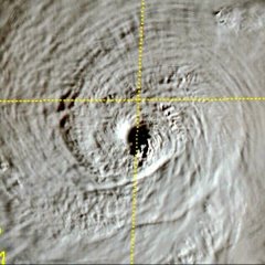
Isaias aumentou de tamanho, e parece estar gerando um olho. Isaias ha 5 horas atras // Isaias agora
-
Alem disso, NHC preve que Isaias vire um furacão.
-
Futuro Josephine Tropical Weather Outlook NWS National Hurricane Center Miami FL 800 AM EDT Thu Jul 30 2020 For the North Atlantic...Caribbean Sea and the Gulf of Mexico: The National Hurricane Center is issuing advisories on Tropical Storm Isaias, located over the northeastern Caribbean Sea. 1. Showers and thunderstorms associated with a broad area of low pressure, located a few hundred miles south-southeast of the Cabo Verde Islands have become more concentrated this morning. Some development of this system is possible during the next day or two before environmental conditions become unfavorable. * Formation chance through 48 hours...low...20 percent. * Formation chance through 5 days...low...20 percent.
-
Os remanecentes de Douglas estão no Pacífico Oeste.
-
Se Isaias gerou um novo centro, passou sobre terra e continua como 60 mph, o sistema vira um furacão?
-
90W se dissipou. (1) THE AREA OF CONVECTION (INVEST 90W) PREVIOUSLY LOCATED NEAR 26.8N 158.2E HAS DISSIPATED AND IS NO LONGER SUSPECT FOR THE DEVELOPMENT OF A SIGNIFICANT TROPICAL CYCLONE IN THE NEXT 24 HOURS.
-
Kkkkkkkkk Mas falando nisso, qual a pronuncia brasileira de Ees-Ah-Ee-Ahs?
-
Tropical Storm Sepat (Dodong)Edit Tropical storm (JMA) Subtropical storm (SSHWS) Duration June 24 – June 28 Peak intensity 75 km/h (45 mph) (10-min) 994 hPa (mbar) On June 24, the JMA began monitoring on a tropical depression that had formed well to the east of Luzon from the remnants of a separate system. On June 25, the system began curving towards the northeast; the PAGASA also began to issue warnings on the formative disturbance.[44] Rounding the periphery of a subtropical ridge of high pressure, the depression tracked towards the east-northeast through the East China Sea, intensifying some as it encountered an area of high sea surface temperatures and low wind shear.[45][46] On June 26, the cyclone left the PAGASA's area of responsibility.[47] Curved banding developed later that day as the center passed east of Okinawa.[48] Tracing the northwestern periphery of the ridge, the system curved towards the east-northeast, paralleling the southern coast of the main Japanese islands. Supported by favorable sea surface temperatures and outflow, the system was upgraded to a tropical storm at 09:00 UTC on June 27, gaining the name Sepat.[49] A peak intensity with 75 km/h (47 mph) 10-minute sustained winds was attained later that day while Sepat began to acquire extratropical characteristics.[50][51] The next day, the storm fully transitioned into an extratropical system while accelerating eastward 580 km (360 mi) east of Hitachinaka, Japan.[52] Sepat's extratropical remnants continued accelerating towards the northeast, moving into the western Bering Sea on July 1, before eventually dissipating over the Arctic Ocean early on July 5.
-
Yes friend
-
Vai la saber....... O HWRF sai fora da casinha em 95% das previsões
-
AccuWeather, migles
-
Olhando bem as imagens de satelite o sistema está bem organizado, CDO bonito, e bandas de chuva, ventos e trovoadas bem simetricos. Achei estranho o fato do NHC não reconhecer o sistema, pois voltando no tempo, as origens da TS Fay eram muito muito menores do que essa onda, e o NHC apostou todas suas fichas naqule sistema para hoje nem triscar uma unha nas teclas para notificar a formação desse sistema africano (onda tropical). A subestimação do NHC preocupa, pois isso afeta a o sistema em sua real intensidade e a população, pois se minha memoria não falha, me lembro que uma vez que na decada de 1970, 80 (num sei a decada) tinha um sistema desconhecido em alguma bacia, que a agencia que monitorou o sistema foi subestimar o sistema, que se fosse hoje, seria uma forte TS, mas que a tal agencia estimou um TD. O povo não aguardava ventos e chuvas tão fortes, colocando a estimativa para baixo, deixando tantos mortos, feridos, desaparecidos e etc. Agora, para o NHC reconhecer o sistema, dar tal chance de se formar em tal hora e tal dia e dar aval para que o sistema vire TD ou TS vai demorar milênios de anos.
-
Me da link que eu quero conhecer kkkk Eu nem sabia que existia forum americano desse porte...
-
Josephine 😊 O NHC ta pouco se lixando pra esse sistema. Será que bateremos recordes de Katrina? Esse topico do BAZ ta virando historico!
-
Aki em casa tbm.... Me preparando para infartar quando chegar a conta de luz 😂 Ar condicionado e ventilador ligados ao mesmo tempo. A previsão do tempo errou profundamente. Disseram que iria cair um toró de chuva aqui no interior de SP.... Fui tapeado!
-
Affffff Aqui ta fazendo 31°C....
-
Very Good! But, be careful with TS Isaias, because any mistake of preparation and care against the cyclone can be too dangerous! Tradução: Muito Bom! Mas, tome cuidado com a TS Isaias, pois qualquer errinho de preparação e cuidados contra o ciclone poderá ser perigoso demais!


