

mario junior
-
Posts
162 -
Joined
-
Last visited
Content Type
Profiles
Forums
Gallery
Calendar
Posts posted by mario junior
-
-
Uiiiii......
212200 1626N 07914W 6934 03094 9883 +121 //// 114058 063 057 003 01
-
 1
1
-
-
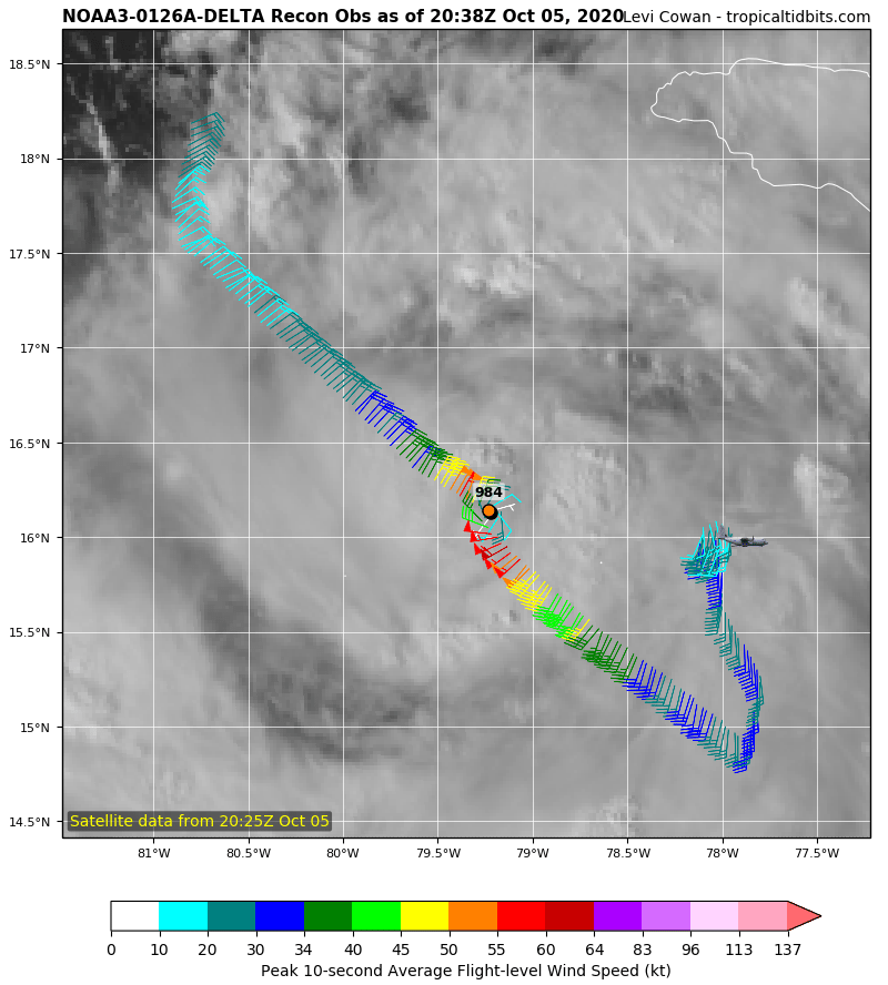
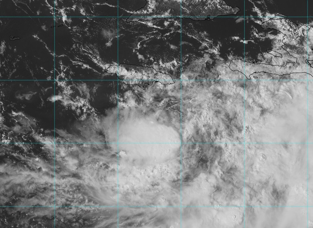
PRESSÃO DE 977 MBAR FOI ENCONTRADA EM DELTA!
212830 1616N 07919W 6961 03010 9778 +162 //// 126008 011 026 000 05
mas os ventos não aconpanharam a queda e não foram reportados ventos ventos acima de 64 kt no voo.
-
3
-
-
TropicalTidbits mostra que o voo de reconhecimento em Delta ja terminou. Porque sera?

-
2 horas atrás, Tavares disse:
TS Delta, 2020
TS Wilma, 2005
Por isso eu disse que Delta pode ser um categoria 5.
-
1
-
-
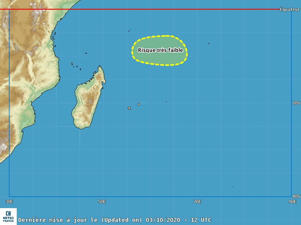
MFR monitora também uma possível SD ao sudeste de Madagascar, assim abrindo a temporada de ciclones tropicais do Hemisferio Sul 2020 21.
ACTIVITE DANS LE DOMAINE TROPICAL:
L'activité convective s'est affaiblie au cours des dernières 24h sur le Nord-Est du bassin. Les
données Ascat ainsi que l'imagerie satellite montrent la présence d'une vaste zone de basses
pressions à l'est immédiat de Diego Garcia. L'activité convective est principalement présente sur la
façade sud de ce thalweg dans la zone de convergence des alizés.
A partir de mercredi, une petite circulation fermée en surface pourrait se former et se creuser à la
faveur d'un environnement un peu plus favorable : apparition d'une faible convergence équatorial et
baisse temporaire de la contrainte modérée à forte de cisaillement vertical de secteur Est, à l'image
du GFS 00Z. Le risque de formation d'une tempête reste néanmoins encore assez faible à cause
d'une probable hausse du cisaillement dès jeudi comme suggeré par les runs de 00Z de IFS . Ce
système est dans tous les cas prévu se déplacer en direction générale de l'Ouest au cours des 5
prochains jours.
Pour les 5 prochains jours, le risque de formation d'une tempête tropicale modérée reste très
faible à partir de mercredi sur le centre du bassin.
Au sud des Mascareignes, un creusement barocline devrait favoriser la formation d'un minimum
dépressionnaire au cours des prochaines heures, se déplacant rapidement vers le sud. En journée de
mardi, ce minimum pourrait évoluer temporairement dans des conditions favorables à une transition
tropicale avec une baisse sensible du cisaillement, une excellente divergence d'altitude et des
températures de surface de la mer encore supérieures à 20°C. Dans ces conditions, bien que le
phasage des différents élements (minimum de surface, cisaillement,...) semble encore très incertain,
certains runs du modèles GFS (18Z,00Z) proposent dans leur scénario la formation d'un système
gagnant des caractéristiques tropicales avec des vents de force coup de vent (8 beaufort). Les
différents modèles de l'ECMWF ne suggèrent pas une telle évolution.
Pour les 5 prochains jours, le risque de formation d'une transition tropicale (formation d'une
dépression subtropicale) au sud des Mascareignes devient faible demain mardi et mercredi.-----------------
Tradução
-----------------
ATIVIDADE NO CAMPO TROPICAL: A atividade convectiva enfraqueceu nas últimas 24 horas no nordeste da bacia. o Os dados Ascat, bem como as imagens de satélite, mostram a presença de uma grande área de graves pressões imediatamente a leste de Diego Garcia. A atividade convectiva está presente principalmente no fachada sul deste talvegue na zona de convergência dos ventos alísios. A partir de quarta-feira, uma pequena circulação fechada na superfície pode se formar e se alargar na favorecem um ambiente ligeiramente mais favorável: aparecimento de uma convergência equatorial fraca e queda temporária na tensão de cisalhamento vertical moderada a forte do setor leste, conforme mostrado na de GFS 00Z. No entanto, o risco de formação de uma tempestade ainda é bastante baixo devido a um provável aumento no cisalhamento na quinta-feira, conforme sugerido pelas execuções 00Z do IFS. Esta sistema está, em qualquer caso, planejado para se mover na direção geral do oeste durante os 5 próximos dias. Pelos próximos 5 dias, o risco de formação de uma tempestade tropical moderada permanece muito fraco de quarta-feira no centro da bacia. Ao sul dos Mascarenes, uma escavação baroclínica deve favorecer a formação de um mínimo baixo nas próximas horas, movendo-se rapidamente para o sul. Durante o dia de Terça-feira, este mínimo pode mudar temporariamente em condições favoráveis para uma transição tropical com uma queda significativa no cisalhamento, excelente divergência de altitude e temperaturas da superfície do mar ainda acima de 20 ° C. Nessas condições, embora o o faseamento dos diferentes elementos (área mínima, cisalhamento, ...) ainda parece muito incerto, algumas execuções dos modelos GFS (18Z, 00Z) propõem em seu cenário a formação de um sistema ganhando características tropicais com ventos fortes (8 Beaufort). o diferentes modelos do ECMWF não sugerem tal desenvolvimento. Para os próximos 5 dias, o risco de formação de uma transição tropical (formação de um depressão subtropical) ao sul do Mascarenes torna-se fraco amanhã terça e quarta-feira.
-
3
-
-
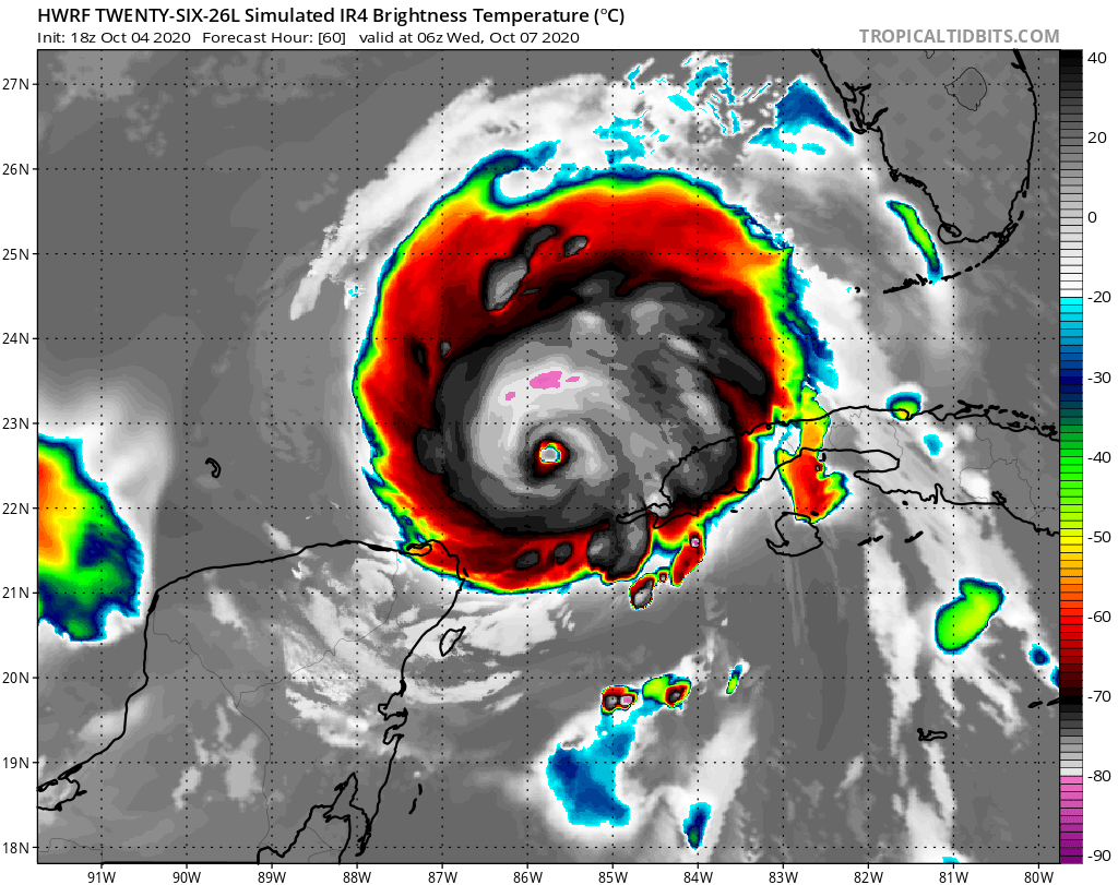
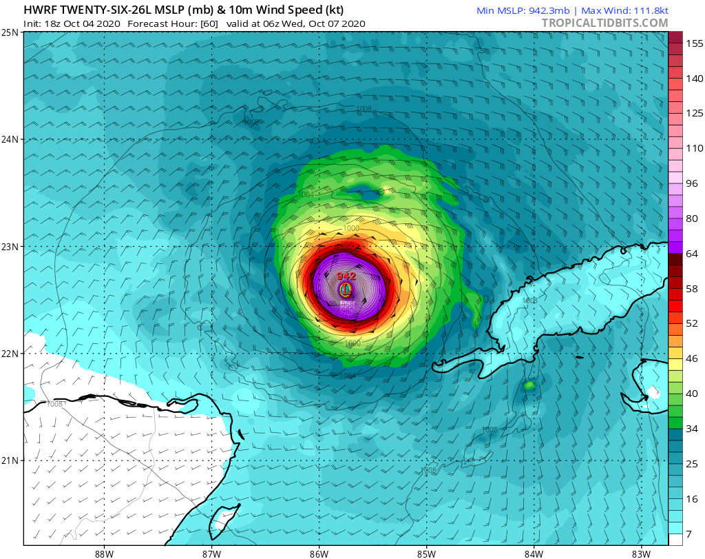
Απλώς λέω wow για το μοντέλο HWRF για αυτήν την πρόβλεψη της Delta.
Simplesmente digo uau para essa previsão do modelo HWRF sobre Delta.
-
7
-
-
Olhando bem, quase todos os modelos que vi ate agora nas previsões para Delta mostram o sistema sendo furacão ainda no caribe e alguns apostam rapida intesificação. Eu acho que Delta poderá ser *talvez* um fraco categoria 5, ou talvez algo mais fraco. Seguindo os passos do @Miguel Russe.
-
3
-
-
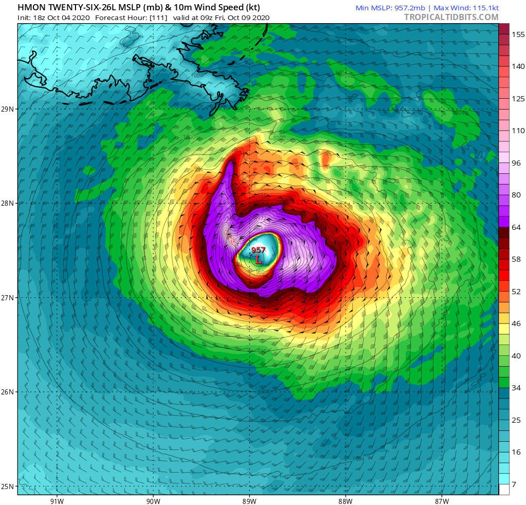
HMON coloca um CATEGORIA 4 no golfo. É o modelo mais interessante que vi até aqui em relação ao PTC 26L (Delta).
-
6
-
-
44 minutos atrás, Felipe F disse:
HWRF
Deltinho rs
-
1
-
 2
2
-
-
Ferrou, né Nova Orleães??
-
8
-
-
Ue
Special Message from NHC Issued 4 Oct 2020 20:12 UTC NHC will initiate advisories on Potential Tropical Cyclone 26, located in the central Caribbean Sea, at 500 PM EDT (2100 UTC).-
7
-
-
Modelos indicam 92L como um forte furacão que está a caminho.
-
6
-
-
92L vem persistindo nos ultimos dias com uma organização gradual e já pode ser um TD.
NHC propôs 80% de chances de ser tornar uma depressão tropical.
Próximo nome do alfabeto grego é Delta.
1. A broad area of low pressure is located over the central Caribbean
Sea, a little less than 100 miles south-southeast of eastern
Jamaica.  Recent satellite wind data and visible satellite imagery
indicate that the circulation is gradually becoming better defined,
however, the associated shower and thunderstorm activity has
changed little in organization since this morning.  Environmental
conditions are expected to be conducive for additional development,
and a tropical depression is likely to form within the next day or so, while the system moves over the central and northwestern
Caribbean Sea. The disturbance is forecast to move near Jamaica
through Monday, and then pass near the Cayman Islands early Tuesday
and approach western Cuba by late Tuesday, and interests in those
areas should closely monitor the progress of this system.  The low
is forecast to move into the southern or southeastern Gulf of
Mexico Tuesday night or Wednesday.  Regardless of development,
locally heavy rainfall and gusty winds will be possible across
portions of Hispaniola, Jamaica, the Cayman Islands, and Cuba
during the next few days.  This rainfall could lead to
life-threatening flash floods and mudslides.
* Formation chance through 48 hours...high...80 percent.
* Formation chance through 5 days...high...80 percent.
-
4
-
-
O Météo France la Reunión começou a monitorar uma área a nordeste de Madagascar.
O Météo France diz que o risco de formação de um TC é muito fraca. entretanto, o MFR não descarta uma melhora nas condições.
Primeiro nome é Alicia.
AWIO21 FMEE 031134
CENTRE DES CYCLONES TROPICAUX / CMRS DE LA REUNION / METEO-FRANCE
BULLETIN SUR L'ACTIVITE CYCLONIQUE ET LES CONDITIONS
METEOROLOGIQUES TROPICALES SUR LE SUD-OUEST DE L'OCEAN INDIEN
LE 03/10/2020 A 1200 UTC
PARTIE 1:
AVIS SPECIAUX EN COURS:
Néant.
PARTIE 2 :
ACTIVITE DANS LE DOMAINE TROPICAL:
Le bassin conserve sa configuration hivernale avec des alizés remontant jusqu'à l'équateur.
Toutefois, la convection profonde est en place depuis quelques jours dans la zone proche équatorial
sur l'extrême Nord-Est de notre bassin. En lien avec une activité ondulatoire, et notamment une
onde Equatoriale Rossby (analyse faite à partir des anomalies de vent à 850hPa), une circulation
pourrait s'organiser depuis la partie est du bassin au sein d'un thalweg proche équatoriale.
Toutefois l'environnement reste globalement défavorable à la cyclogénèse : peu ou pas de
convergence côté équatorial, persistance d'une contrainte modérée à forte de cisaillement vertical de
secteur Est. En fin d'échéance, ces conditions pourraient cependant légèrement s'améliorer avec un
baisse de la contrainte et une meilleure alimentation côté équatoriale. Le risque de creusement au
stade tempête ne peut donc pas être totalement exclu alors.
Pour les 5 prochains jours, le risque de formation d'une tempête tropicale modérée devient
très faible à partir de mercredi sur le centre du bassin.---------------------
Tradução:
---------------------
AWIO21 FMEE 031134 CENTRO DE CICLONOS TROPICAIS / CMRS DE LA REUNION / METEO-FRANÇA BOLETIM DE ATIVIDADE CICLÔNICA E CONDIÇÕES TEMPO TROPICAL SOBRE O SUDOESTE DO OCEANO ÍNDICO EM 03/10/2020 ÀS 1200 UTC PARTE 1: CONSELHOS ESPECIAIS EM ANDAMENTO: Nenhum. PARTE 2 : ATIVIDADE NO CAMPO TROPICAL: A bacia mantém sua configuração de inverno com ventos alísios subindo para o equador. No entanto, a convecção profunda está em vigor há alguns dias na zona equatorial próxima. no extremo nordeste da nossa bacia. Em conexão com uma atividade de ondas e, em particular, um Onda equatorial de Rossby (análise feita a partir de anomalias do vento a 850hPa), uma circulação poderia ser organizado a partir da parte oriental da bacia dentro de um talvegue quase equatorial. No entanto, o ambiente permanece geralmente desfavorável à ciclogênese: pouco ou nenhum convergência no lado equatorial, persistência de uma tensão de cisalhamento vertical moderada a alta de Setor leste. No final do prazo, no entanto, essas condições podem melhorar ligeiramente com um menor estresse e melhor suprimento no lado equatorial. O risco de cavar o estágio de tempestade não pode, portanto, ser completamente excluído. Durante os próximos 5 dias, o risco de formação de uma tempestade tropical moderada torna-se muito fraco na quarta-feira no centro da bacia.
-
3
-
 1
1
-
-
1 hora atrás, Felipe F disse:
Voo de reconhecimento enfrentou problemas e não enviou dados
Quais problemaS?
-
...DEPRESSION BECOMES TROPICAL STORM GAMMA OVER THE NORTHWESTERN
CARIBBEAN SEA...


SUMMARY OF 700 PM CDT...0000 UTC...INFORMATION
----------------------------------------------
LOCATION...18.8N 85.8W
ABOUT 135 MI...220 KM SSE OF COZUMEL MEXICO
MAXIMUM SUSTAINED WINDS...40 MPH...65 KM/H
PRESENT MOVEMENT...NW OR 315 DEGREES AT 9 MPH...15 KM/H
MINIMUM CENTRAL PRESSURE...1000 MB...29.53 INCHES
-
1
-
1
-
-
-
Raspou a categoria 4!
196
WTPZ33 KNHC 020234
TCPEP3

BULLETIN
Hurricane Marie Advisory Number  12
NWS National Hurricane Center Miami FL       EP182020
800 PM PDT Thu Oct 01 2020

...MARIE BECOMES A MAJOR HURRICANE...


SUMMARY OF 800 PM PDT...0300 UTC...INFORMATION
----------------------------------------------
LOCATION...15.6N 122.1W
ABOUT 940 MI...1515 KM WSW OF THE SOUTHERN TIP OF BAJA CALIFORNIA
MAXIMUM SUSTAINED WINDS...125 MPH...205 KM/H
PRESENT MOVEMENT...WNW OR 285 DEGREES AT 15 MPH...24 KM/H
MINIMUM CENTRAL PRESSURE...957 MB...28.26 INCHES
-
3
-
-
48 minutos atrás, Rodolfo Alves disse:
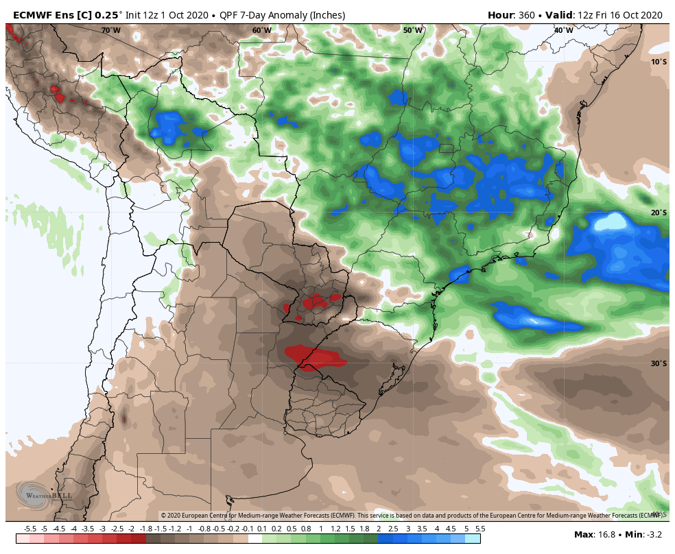
CENÁRIO ATERRORIZANTE PARA OS PRÓXIMOS 10 DIAS.
MÉDIA DO ECMWF 12Z
O BLOQUEIO IRÁ GANHAR FORÇA NESSA PRIMEIRA QUINZENA DO MÊS
A BOA NOTÍCIA É QUE O MODELO EUROPEU NA VERSÃO ESTENDIDA COMEÇA A APONTAR PARA O RETORNO DAS CHUVAS ENTRE O SUDESTE E O CENTRO-OESTE PARA APÓS O DIA 10 DE OUTUBRO
Cruz credo
Torcendo pra ser completamente ao contrario, e faça cair uma boa chuvinha aqui
-
3
-
-
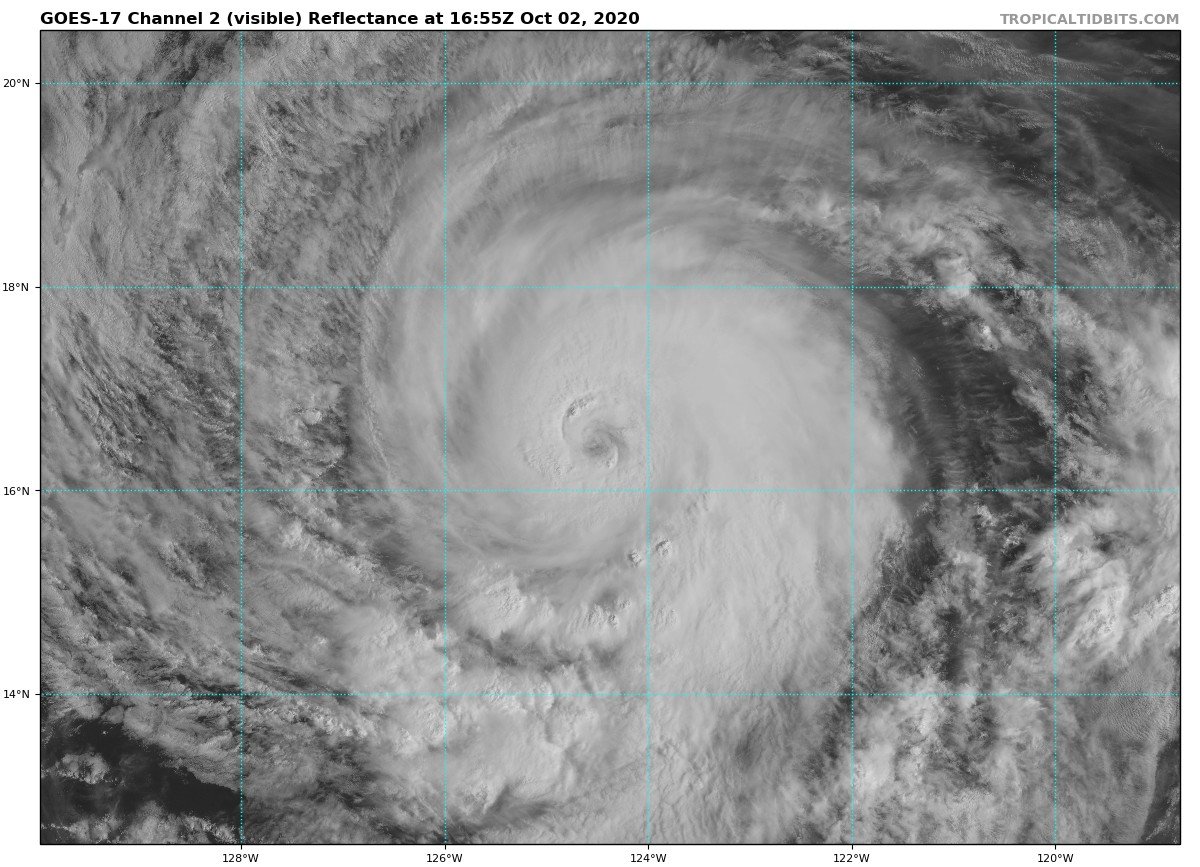
Merie fortalece a categoria 1.
Sera um poderoso furacão.
INIT  30/2100Z 14.3N 115.1W   65 KT  75 MPH
 12H  01/0600Z 14.4N 117.3W   85 KT 100 MPH
 24H  01/1800Z 14.8N 120.0W  100 KT 115 MPH
 36H  02/0600Z 15.6N 122.5W  115 KT 130 MPH
 48H  02/1800Z 16.6N 124.7W  120 KT 140 MPH
 60H  03/0600Z 17.7N 126.7W  120 KT 140 MPH
 72H  03/1800Z 18.6N 128.4W  100 KT 115 MPH
 96H  04/1800Z 20.3N 131.4W   70 KT  80 MPH
120H  05/1800Z 21.8N 134.0W   50 KT  60 MPH
-
4
-
-
Auriflama - SP
29/09/2020
-
5
-
4
-
 1
1
-
-
Marie será categoria 4 nessa nova previsão do NHC.
000
WTPZ33 KNHC 301443
TCPEP3

BULLETIN
Tropical Storm Marie Advisory Number   6
NWS National Hurricane Center Miami FL       EP182020
900 AM MDT Wed Sep 30 2020

...MARIE A LITTLE STRONGER...
...FORECAST TO RAPIDLY INTENSIFY AND BECOME A HURRICANE TONIGHT...


SUMMARY OF 900 AM MDT...1500 UTC...INFORMATION
----------------------------------------------
LOCATION...14.2N 113.8W
ABOUT 655 MI...1050 KM SSW OF THE SOUTHERN TIP OF BAJA CALIFORNIA
MAXIMUM SUSTAINED WINDS...65 MPH...100 KM/H
PRESENT MOVEMENT...W OR 275 DEGREES AT 16 MPH...26 KM/H
MINIMUM CENTRAL PRESSURE...997 MB...29.44 INCHES
FORECAST POSITIONS AND MAX WINDS

INIT  30/1500Z 14.2N 113.8W   55 KT  65 MPH
 12H  01/0000Z 14.3N 116.1W   65 KT  75 MPH
 24H  01/1200Z 14.5N 118.9W   85 KT 100 MPH
 36H  02/0000Z 15.1N 121.5W  100 KT 115 MPH
 48H  02/1200Z 15.9N 123.9W  110 KT 125 MPH
 60H  03/0000Z 16.9N 125.9W  115 KT 130 MPH
 72H  03/1200Z 18.0N 127.6W  100 KT 115 MPH
 96H  04/1200Z 19.8N 130.7W   75 KT  85 MPH
120H  05/1200Z 21.1N 133.4W   55 KT  65 MPH
-
3
-
-
TS Marie se forma no EPAC.
000
WTPZ33 KNHC 292033
TCPEP3

BULLETIN
Tropical Storm Marie Advisory Number   3
NWS National Hurricane Center Miami FL       EP182020
300 PM MDT Tue Sep 29 2020

...TROPICAL STORM MARIE FORMS WELL SOUTH OF THE BAJA CALIFORNIA
PENINSULA...


SUMMARY OF 300 PM MDT...2100 UTC...INFORMATION
----------------------------------------------
LOCATION...13.6N 109.5W
ABOUT 645 MI...1035 KM S OF THE SOUTHERN TIP OF BAJA CALIFORNIA
MAXIMUM SUSTAINED WINDS...40 MPH...65 KM/H
PRESENT MOVEMENT...W OR 275 DEGREES AT 12 MPH...19 KM/H
MINIMUM CENTRAL PRESSURE...1005 MB...29.68 INCHES
E previsto para ser grande furacão pelo NHC e os demais modelos.
680
WTPZ43 KNHC 292033
TCDEP3

Tropical Storm Marie Discussion Number   3
NWS National Hurricane Center Miami FL       EP182020
300 PM MDT Tue Sep 29 2020

A WindSat microwave image from earlier this morning indicated that
the tropical cyclone's low-level circulation was becoming better
defined, with perhaps the formative stage of a cyan ring seen in the
37-GHz channel.  Visible images also show the center tucked just
beneath recent bursts of deep convection, and Dvorak estimates have
risen to T2.0 and T2.5 from TAFB and SAB, respectively.  These data,
along with ambiguity analyses of recent ASCAT-B and -C scatterometer
passes, indicate the depression has strengthened to Tropical Storm
Marie with maximum winds of 35 kt.

Marie's future track is probably the most straightforward part of
the forecast.  A mid-tropospheric high anchored over the
southwestern United States is steering Marie westward with an
initial motion of 275/10 kt.  This high will remain the main driver,
forcing the cyclone westward or west-northwestward for the next 3
days.  By days 4 and 5, Marie is likely to reach a break in the
ridge and should slow down a bit and turn toward the northwest.
There are no notable outliers among the track guidance, and the
small spread among the models yields higher-than-normal confidence
in the track forecast.  The new NHC forecast is very similar to the
previous prediction, and is close to the TVCE and HCCA consensus
aids.

The intensity forecast is a little more challenging, but mostly
because a good proportion of the guidance suggests that Marie will
intensify significantly during the next few days.  Relatively low
deep-layer shear, warm ocean waters, and favorable upper-level
divergence all favor strengthening, and several of the various
SHIPS Rapid Intensification thresholds are several times higher
than their climatological means.  In addition, all of the dynamical
models, the consensus aids, and the GFS-based SHIPS model bring
Marie to hurricane strength within 24 hours.  Given these signals,
the NHC intensity forecast has been raised from the previous one
and lies near or just below the intensity consensus in order to
maintain some continuity.  But given what is shown by some of the
better-performing intensity models, I would not be surprised if
subsequent forecasts show a faster rate of intensification or
a higher peak intensity.  Weakening is expected by days 4 and 5 due
to cooler waters and increasing southwesterly shear.

Marie's 12-ft sea radii are larger than would be expected for a
small, just-developing tropical storm due to a large fetch of
southerly swell originating from the Southern Hemisphere.


FORECAST POSITIONS AND MAX WINDS

INIT  29/2100Z 13.6N 109.5W   35 KT  40 MPH
 12H  30/0600Z 13.9N 111.6W   45 KT  50 MPH
 24H  30/1800Z 14.6N 114.5W   60 KT  70 MPH
 36H  01/0600Z 14.9N 117.5W   75 KT  85 MPH
 48H  01/1800Z 15.3N 120.3W   90 KT 105 MPH
 60H  02/0600Z 16.0N 122.7W  100 KT 115 MPH
 72H  02/1800Z 17.2N 124.9W  100 KT 115 MPH
 96H  03/1800Z 19.6N 128.5W   85 KT 100 MPH
120H  04/1800Z 21.4N 131.6W   60 KT  70 MPH

$$
Forecaster Berg
-
3
-
-
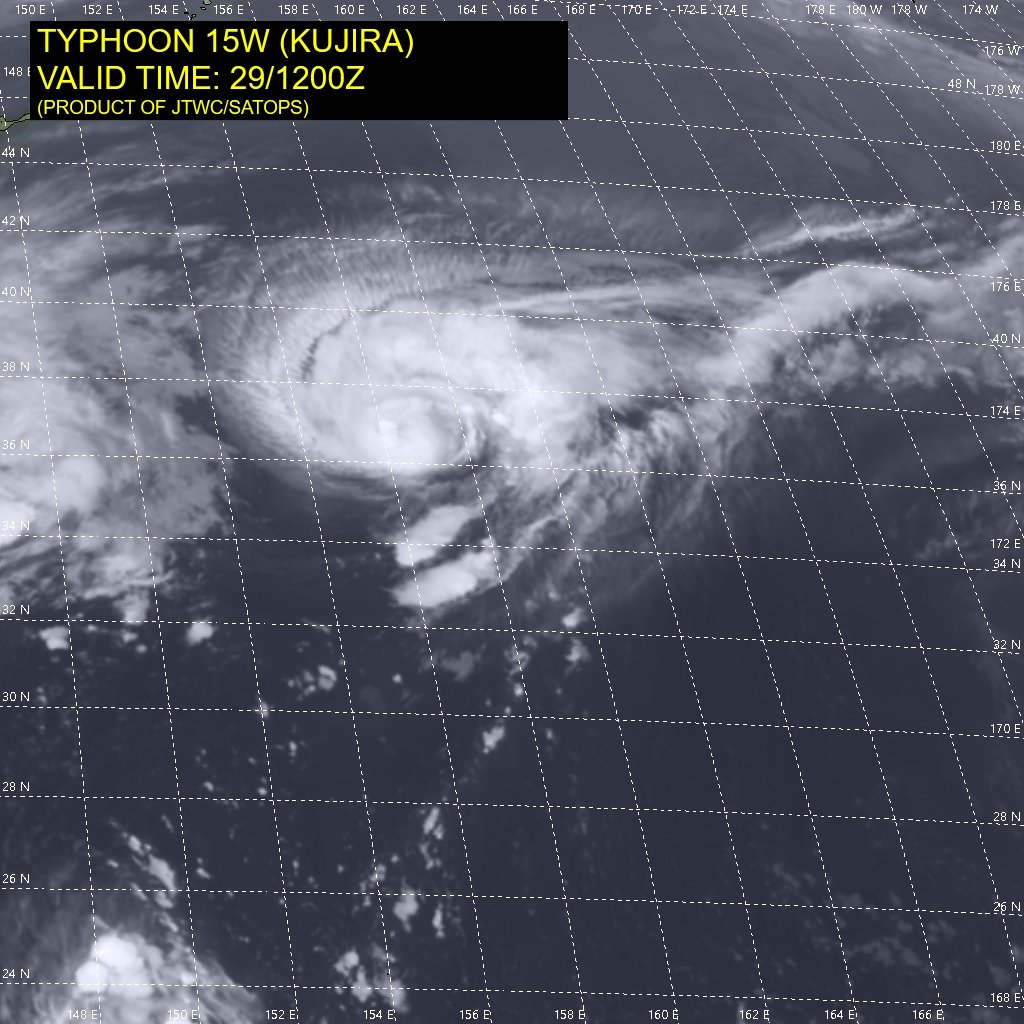
Kujira se intensificou a tufão de categoria 1 mínimo. Rajadas próximas de um categoria 2.
Deve se tornar extra-tropical ainda hoje.
WTPN31 PGTW 291500 MSGID/GENADMIN/JOINT TYPHOON WRNCEN PEARL HARBOR HI// SUBJ/TYPHOON 15W (KUJIRA) WARNING NR 012// RMKS/ 1. TYPHOON 15W (KUJIRA) WARNING NR 012 01 ACTIVE TROPICAL CYCLONE IN NORTHWESTPAC MAX SUSTAINED WINDS BASED ON ONE-MINUTE AVERAGE WIND RADII VALID OVER OPEN WATER ONLY --- WARNING POSITION: 291200Z --- NEAR 36.5N 156.4E MOVEMENT PAST SIX HOURS - 030 DEGREES AT 20 KTS POSITION ACCURATE TO WITHIN 030 NM POSITION BASED ON CENTER LOCATED BY SATELLITE PRESENT WIND DISTRIBUTION: MAX SUSTAINED WINDS - 065 KT, GUSTS 080 KT-
1
-


.png.335cdf7242f938bd987dded0ffd6cb98.png)


Furacões no Atlântico Norte e Pacífico Leste e Central - 2020
in Monitoramento de Furacões, Tufões e Ciclones Tropicais
Posted
Aeee