

mario junior
-
Posts
162 -
Joined
-
Last visited
Content Type
Profiles
Forums
Gallery
Calendar
Posts posted by mario junior
-
-
Eta, Theta e Iota

ZCZC MIATWOAT ALL
TTAA00 KNHC DDHHMM

Tropical Weather Outlook
NWS National Hurricane Center Miami FL
100 PM EST Sun Nov 8 2020

For the North Atlantic...Caribbean Sea and the Gulf of Mexico:

The National Hurricane Center is issuing advisories on Tropical
Storm Eta, located just north of central Cuba.

1. Recent satellite-derived wind data confirm that a low pressure
system has developed several hundred miles southwest of the Azores.
Shower and thunderstorm activity associated with this system is
currently disorganized. However, the low could slowly develop
tropical or subtropical characteristics during the next several days
while it moves eastward or east-northeastward over the northeastern
Atlantic Ocean.
* Formation chance through 48 hours...low...10 percent.
* Formation chance through 5 days...low...30 percent.

2. A tropical wave is forecast to move over the central Caribbean Sea,
where an area of low pressure could form in a few days.
Environmental conditions may be conducive for at least gradual
development thereafter while the system moves slowly westward
through the end of the week.
* Formation chance through 48 hours...low...near 0 percent.
* Formation chance through 5 days...low...20 percent.

Forecaster Zelinsky
-
 3
3
-
-
Acho que sai um categoria 1.
-
2
-
-
-
Primeiro nome: Alicia.
Acho que agora vai!
-
2
-
-
2 minutos atrás, Felipe F disse:
950 mbar!
-
1
-
-
Pode estimar uns 120 kt?
-
3
-
-
-
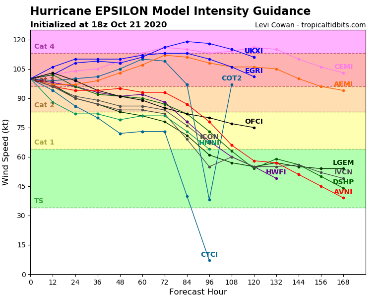
Tem chances de ir pra categoria 4?
3/4 modelos dizem que sim...
-
2
-
 1
1
-
-
12 minutos atrás, Felipe F disse:
Nem Delta teve....
-
 2
2
-
-
-
Amigo Miguel Russe, seu sonho está a um grão de arroz de ser realizado.
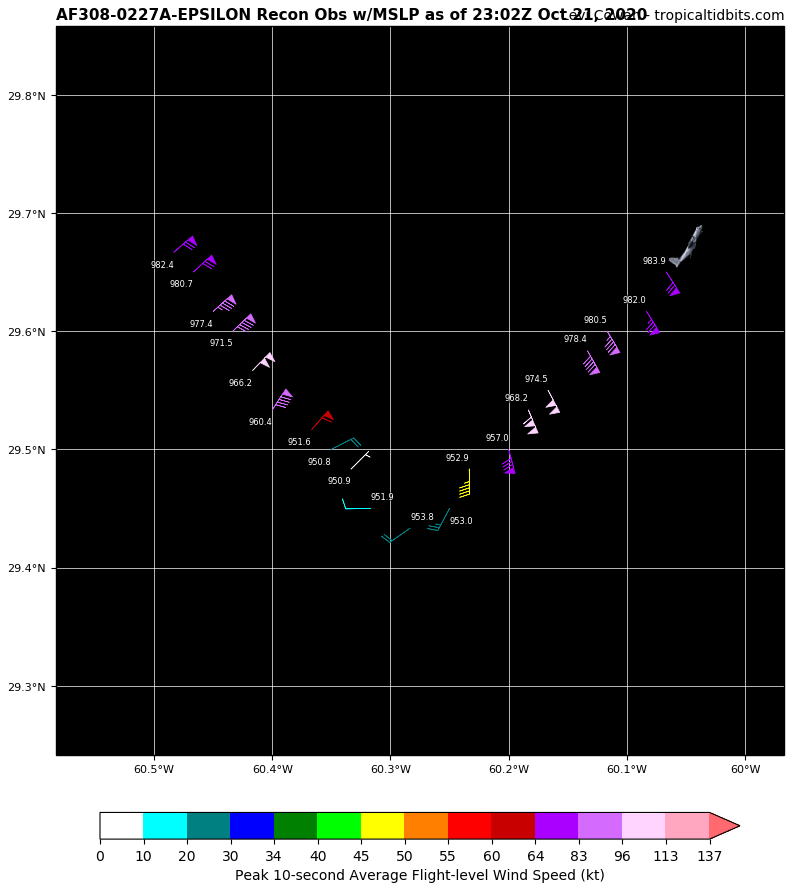
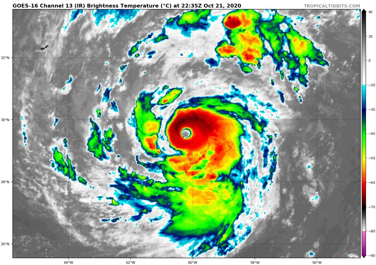
000
WTNT62 KNHC 211732
TCUAT2

Hurricane Epsilon Tropical Cyclone Update
NWS National Hurricane Center Miami FL       AL272020
130 PM AST Wed Oct 21 2020

...AIR FORCE HURRICANE HUNTER AIRCRAFT FINDS EPSILON STRONGER...

Data from an Air Force Reserve Hurricane Hunter aircraft indicate
that Epsilon has continued to strengthen and now has maximum
sustained winds of 110 mph (175 km/h) with higher gusts. A Special
Advisory will be issued by 200 PM AST (1800 UTC) to reflect the
higher initial intensity and adjust the intensity forecast. This
special advisory will be issued in lieu of the 200 PM AST (1800
UTC) intermediate public advisory.


SUMMARY OF 130 PM AST...1730 UTC...INFORMATION
----------------------------------------------
LOCATION...29.3N 59.6W
ABOUT 375 MI...605 KM ESE OF BERMUDA
MAXIMUM SUSTAINED WINDS...110 MPH...175 KM/H
PRESENT MOVEMENT...WNW OR 285 DEGREES AT 12 MPH...19 KM/H
MINIMUM CENTRAL PRESSURE...959 MB...28.32 INCHES
-
3
-
-
949 mbar encontrados em Delta.
235430 2509N 09331W 6967 02743 9491 +196 +092 253009 016 010 000 00
-
1
-
-
120 kt encontrados em Delta.
Não duvido um categoria 4 até amanhã.
234630 2529N 09318W 6956 02866 9682 +136 +136 130115 120 087 014 00
-
2
-
-
000
WTNT31 KNHC 082055
TCPAT1

BULLETIN
Hurricane Delta Advisory Number  17
NWS National Hurricane Center Miami FL       AL262020
400 PM CDT Thu Oct 08 2020

...DELTA REGAINS MAJOR HURRICANE STRENGTH OVER THE WESTERN GULF OF
MEXICO...
...HURRICANE CONDITIONS AND LIFE-THREATENING STORM SURGE EXPECTED
TO BEGIN ALONG PORTIONS OF THE NORTHERN GULF COAST ON FRIDAY...


SUMMARY OF 400 PM CDT...2100 UTC...INFORMATION
----------------------------------------------
LOCATION...24.8N 93.4W
ABOUT 345 MI...555 KM S OF CAMERON LOUISIANA
MAXIMUM SUSTAINED WINDS...115 MPH...185 KM/H
PRESENT MOVEMENT...NW OR 320 DEGREES AT 12 MPH...19 KM/H
MINIMUM CENTRAL PRESSURE...959 MB...28.32 INCHES
-
2
-
-
Hahhah
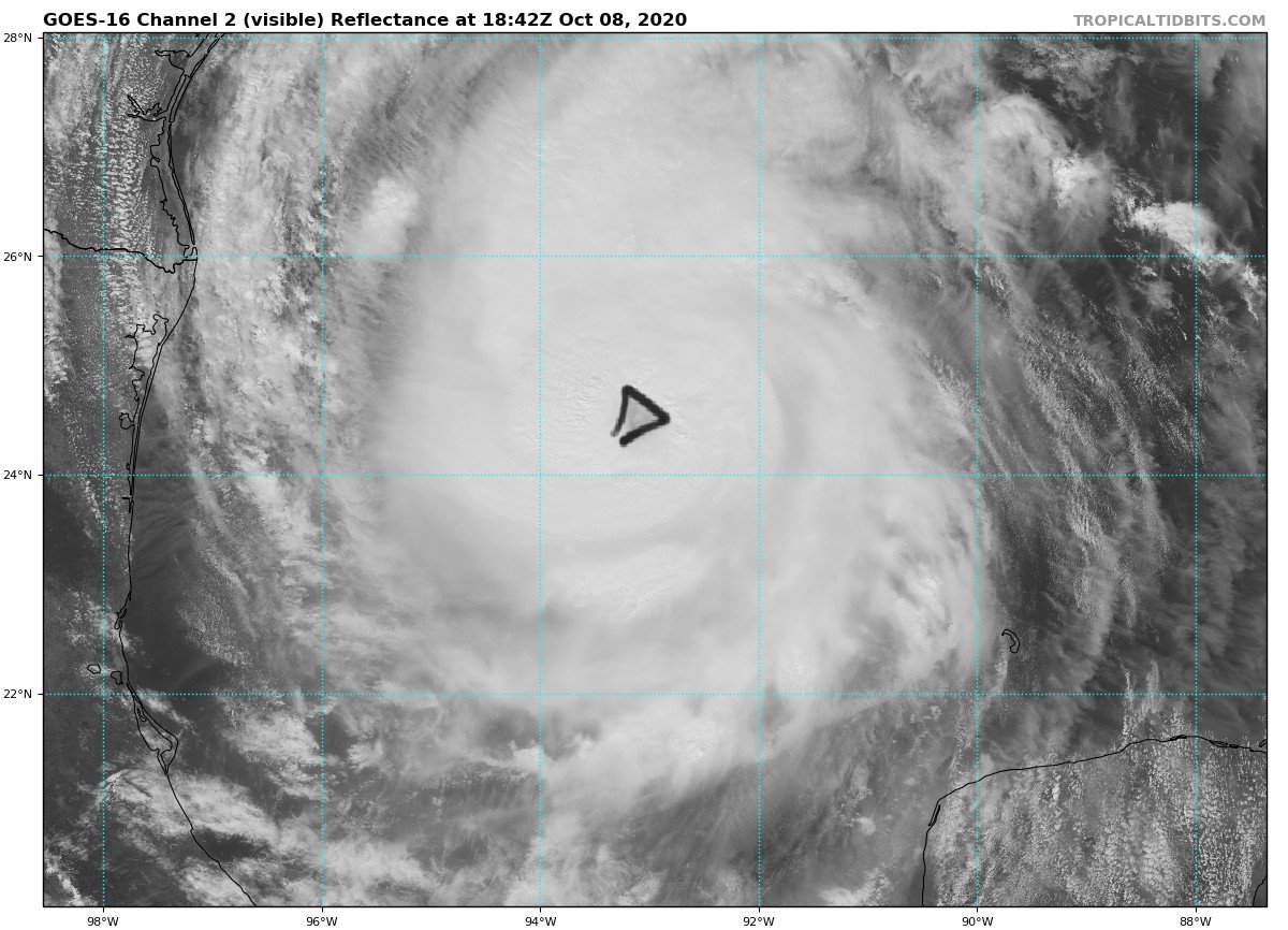
2 minutos atrás, Felipe F disse:Olho de Delta é um delta.
É um triangulo!
-
4
-
-
12 minutos atrás, Felipe F disse:
Delta
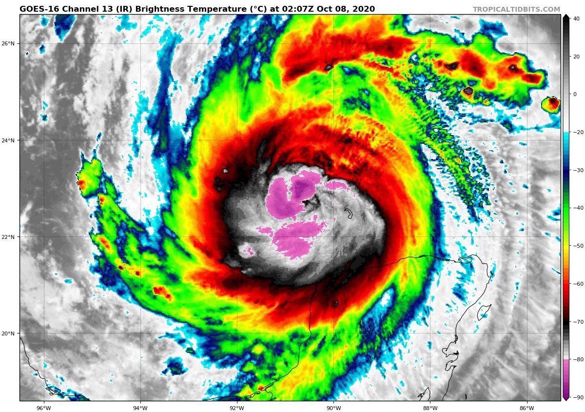
Abriu o olho.
Voo mostra re intensificação de Delta.
-
3
-
-
Será que depois do landfall, Delta pode ter chances novamente de ir pra categoria 5?
-
1
-
-
Delta segue ganhando força.
Acho q a pressão tá alta demais pra um furacão tão poderoso...
BULLETIN
Hurricane Delta Advisory Number   9
NWS National Hurricane Center Miami FL       AL262020
500 PM EDT Tue Oct 06 2020

...EXTREMELY DANGEROUS CATEGORY FOUR HURRICANE DELTA HEADING
TOWARD THE NORTHEASTERN COAST OF THE YUCATAN PENINSULA...
...EXPECTED TO BRING A LIFE-THREATENING STORM SURGE AND EXTREME
WINDS...


SUMMARY OF 500 PM EDT...2100 UTC...INFORMATION
----------------------------------------------
LOCATION...18.9N 84.1W
ABOUT 215 MI...345 KM ESE OF COZUMEL MEXICO
ABOUT 240 MI...385 KM ESE OF TULUM MEXICO
MAXIMUM SUSTAINED WINDS...145 MPH...230 KM/H
PRESENT MOVEMENT...WNW OR 300 DEGREES AT 17 MPH...28 KM/H
MINIMUM CENTRAL PRESSURE...956 MB...28.23 INCHES
-
1
-
-
-
WOW!!!!!
WTNT61 KNHC 061520
TCUAT1

Hurricane Delta Tropical Cyclone Update
NWS National Hurricane Center Miami FL       AL262020
1120 AM EDT Tue Oct 06 2020

...RECENTLY RECEIVED DATA FROM A NOAA HURRICANE HUNTER AIRCRAFT
INDICATE THAT DELTA HAS RAPIDLY STRENGTHENED INTO A CATEGORY 4
HURRICANE...

Data from a NOAA Hurricane Hunter aircraft indicate that Delta is
continuing to rapidly strengthen. The maximum winds have
increased to near 130 mph (215 km/h) with higher gusts.  This makes
Delta a category 4 hurricane on the Saffir-Simpson Hurricane Wind
Scale.


SUMMARY OF 1120 AM EDT...1520 UTC...INFORMATION
---------------------------------------------------
LOCATION...18.2N 82.7W
ABOUT 315 MI...510 KM ESE OF COZUMEL MEXICO
ABOUT 125 MI...200 KM SW OF GRAND CAYMAN
MAXIMUM SUSTAINED WINDS...130 MPH...215 KM/H
PRESENT MOVEMENT...WNW OR 300 DEGREES AT 16 MPH...26 KM/H
MINIMUM CENTRAL PRESSURE...954 MB...28.17 INCHES
-
5
-
-
Será mesmo que Delta pode ir pra categoria 5? Bem que isso faz falta no ATL e no mundo.
-
1
-
-
Bom dia.
BULLETIN
Hurricane Delta Intermediate Advisory Number 7A
NWS National Hurricane Center Miami FL       AL262020
800 AM EDT Tue Oct 06 2020

...NOAA HURRICANE HUNTER AIRCRAFT REPORTS THAT DELTA
CONTINUES TO RAPIDLY STRENGTHEN...
...EXTREMELY DANGEROUS HURRICANE CONDITIONS EXPECTED FOR THE
NORTHEASTERN YUCATAN PENINSULA STARTING EARLY WEDNESDAY...


SUMMARY OF 800 AM EDT...1200 UTC...INFORMATION
----------------------------------------------
LOCATION...17.8N 82.0W
ABOUT 370 MI...595 KM ESE OF COZUMEL MEXICO
ABOUT 115 MI...185 KM SSW OF GRAND CAYMAN
MAXIMUM SUSTAINED WINDS...110 MPH...175 KM/H
PRESENT MOVEMENT...WNW OR 300 DEGREES AT 15 MPH...24 KM/H
MINIMUM CENTRAL PRESSURE...962 MB...28.41 INCHES
-
3
-
-
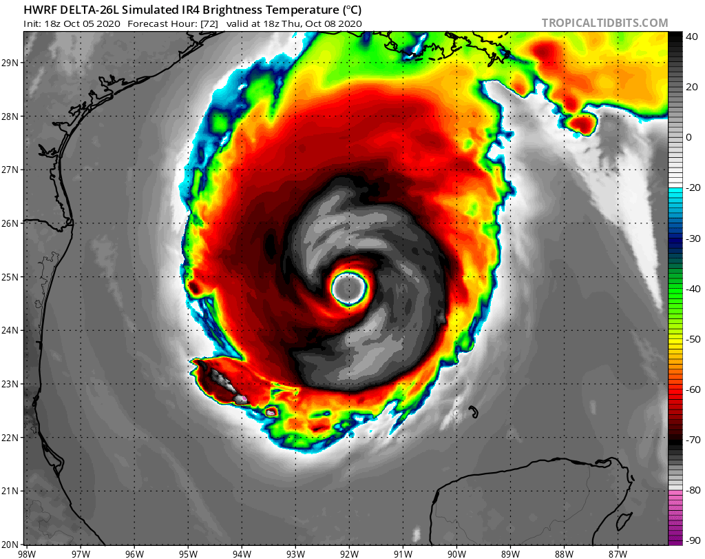
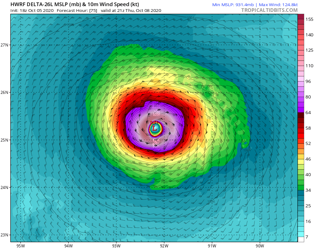
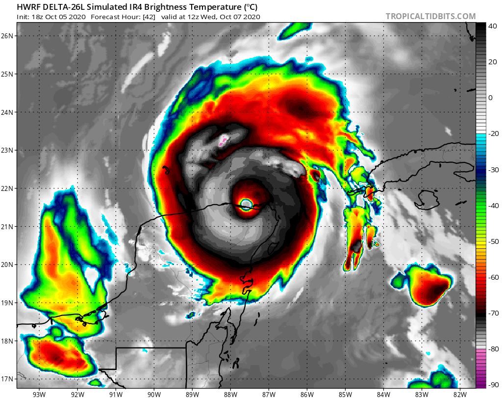
HWRF mostra tbm um poderoso cat. 4 (145 mph e 931 mb) no golfo antes de adentrar nas aguas amenas na costa do EUA.
-
4
-
-
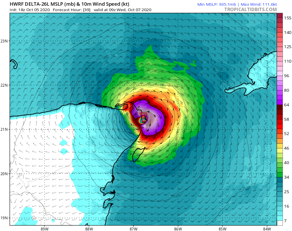
HWRF mostra Delta atingindo Cancún como um categoria 4. Cancún foi a cidade onde o CHAVES (Roberto Bolanos) morou por anos antes de dizer adeus.
-
4
-


Furacões no Atlântico Norte e Pacífico Leste e Central - 2020
in Monitoramento de Furacões, Tufões e Ciclones Tropicais
Posted
GFS prevê o caribe pegando fogo denovo com um possivel Iota.