

Lourenco
-
Posts
160 -
Joined
-
Last visited
Content Type
Profiles
Forums
Gallery
Calendar
Posts posted by Lourenco
-
-
2 horas atrás, Tavares disse:
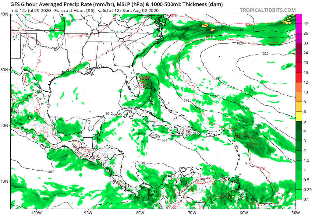
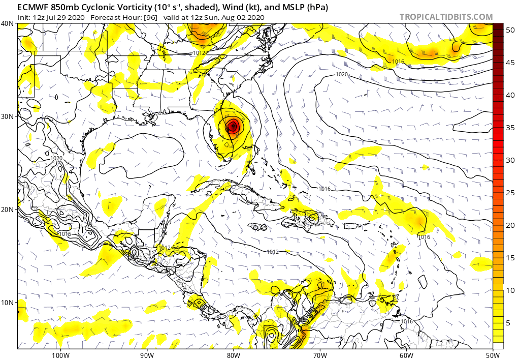
Se o sistema se aproximar muito da ilha de Hispaniola sem que tenha consolidado um centro de circulação ao sul do como prevê o NHC, fatalmente o centro do sistema se formará na parte norte onde estão os ventos mais intensos e aí o caminho da PTC9 sobe uns 2º levando o sistema pras Bahamas e a costa Atlântica dos EUA.
Na saída 12z do GFS e do ECMWF mostram o PTC9 na Costa Leste Americana. Mas o NHC coloca ele mais a West no Golfo.

-
 2
2
-
-
53 minutos atrás, Felipe F disse:
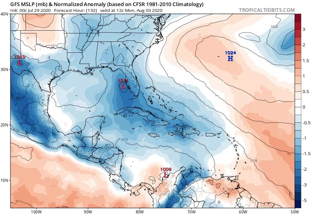
O NHC agora está colocando o PTC 09 quase em Cuba e na Costa West da Flórida. Já o GFS esta mudando bem.....colocando mais a West ainda, dentro do Golfo.
-
3
-
-
1 minuto atrás, Tavares disse:
Primeiro aviso do potencial ciclone tropical nove
Somente uma Tropical Storm?
-
Evacuar somente áreas de risco próximo ao litoral, rios e algumas residências móveis tipo trailers.
Mas como cat.1 acho difícil ter uma evacuação em massa aqui, somente cat.3 pra cima.
Passamos em 2016 algo semelhante com o Matthew
-
1
-
-
Não sei se devido a velocidade do 92L, já estão esperando o ciclone novamente na Costa Leste Americana, só que mais fraco que anteriormente. Vamos aguardar......
-
3
-
-
-
2 horas atrás, Rodolfo Alves disse:
NHC AUMENTOU PARA 80% (2 DIAS) E 90% (5 DIAS) A CHANCE DE 92L VIRAR UMA DEPRESSÃO TROPICAL.
Tropical Weather Outlook
NWS National Hurricane Center Miami FL
800 PM EDT Sun Jul 26 2020
1. Shower activity is becoming a little better organized in
association with a broad area of low pressure located over the
central tropical Atlantic about midway between the coast of Africa
and the Lesser Antilles.  Environmental conditions are expected to
become increasingly conducive for development of this system, and a
tropical depression or tropical storm is likely to form within the
next day or two while moving westward to west-northwestward at
15 to 20 mph.  This system is expected to begin affecting portions
of the Lesser Antilles on Wednesday or Wednesday night, and
interests on those islands should continue to monitor its progress.
* Formation chance through 48 hours...high...80 percent.
* Formation chance through 5 days...high...90 percent.
E pelo jeito os modelos estão indicando que 92L não vai atingir a Flórida mesmo ???
-
Ainda mais pq vejo o pessoal aqui achando q vai ser só uma chuvinha e mais nada.....
-
 2
2
-


Furacões no Atlântico Norte e Pacífico Leste e Central - 2020
in Monitoramento de Furacões, Tufões e Ciclones Tropicais
Posted · Edited by Lourenco
Pq o HWRF está prevendo agora um Cat.4