
Felipe F
-
Posts
12950 -
Joined
-
Last visited
-
Days Won
147
Content Type
Profiles
Forums
Gallery
Calendar
Everything posted by Felipe F
-
Até o momento houve apenas report de granizo. Um aviso de tornado está em vigor no momento.
-
Rotação aumentando próximo de Paoli, OK. Wall cloud foi reportada. Próximo de Purcell, OK tem outra tempestade se organizado que poderia gerar um tornado.
-
Intrusão de ar seco impediu um maior fortalecimento de Debbie até o momento. O ciclone nas últimas horas se tornou melhor organizado e o olho pode ser visto. Radar: http://www.bom.gov.au/products/IDR241.loop.shtml
-
Distúrbio está agora sendo acompanhado. AL, 90, 2017032518, , BEST, 0, 199N, 685W, 30, 1009, LO, 0, , 0, 0, 0, 0, 1012, 180, 150, 0, 0, , 0, , 0, 0, INVEST, , AL, 90, 2017032600, , BEST, 0, 209N, 685W, 30, 1009, LO, 0, , 0, 0, 0, 0, 1012, 180, 150, 0, 0, , 0, , 0, 0, INVEST, , AL, 90, 2017032606, , BEST, 0, 216N, 687W, 30, 1009, LO, 0, , 0, 0, 0, 0, 1012, 180, 150, 0, 0, , 0, , 0, 0, INVEST, , AL, 90, 2017032612, , BEST, 0, 226N, 688W, 35, 1009, LO, 34, NEQ, 150, 0, 0, 0, 1012, 180, 150, 0, 0, , 0, , 0, 0, INVEST, , AL, 90, 2017032618, , BEST, 0, 235N, 690W, 35, 1009, LO, 34, NEQ, 150, 0, 0, 0, 1013, 180, 150, 0, 0, L, 0, , 0, 0, INVEST
-
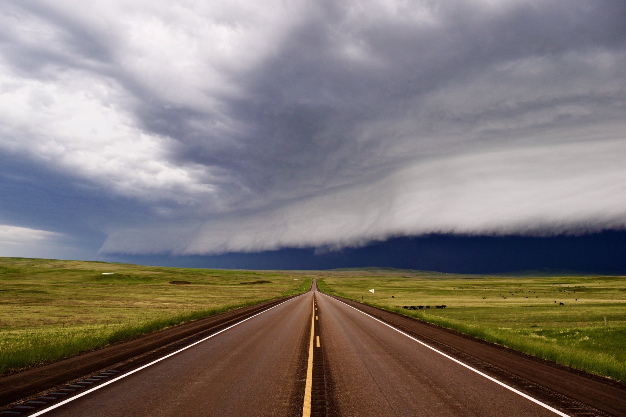
Alerta de tornado emitido para OK e TX. Maior risco será granizo, mas existe a chance de tornados fortes. O alerta inclui Dallas e OKC. Storm chasers Brandon Sullivan:
-
Radar: http://www.news9.com/category/158742/interactive-esp-radar'>http://www.news9.com/category/158742/interactive-esp-radar TV: http://www.news9.com/ Listas no twitter: https://twitter.com/USTornadoes/lists/tornado-chasers https://twitter.com/USTornadoes/lists/general-weather-news https://twitter.com/USTornadoes/lists/meteorologists Tempo severo deve durar toda semana praticamente. Terça pode ser significativo em áreas do Texas, quarta na região do Arlatex e quinta no MS e AL.
-
Alerta de tornado deve ser emitido em breve.
-
National Hurricane Center segue sem acompanhar o distúrbio. Temporada 2016 Nomes Matthew e Otto foram aposentados e substituídos por Martin e Owen.
-
Ontem tivemos um tornado e anteontem tivemos seis, sendo que um deixou seis feridos em uma cidade do Arkansas. Esse tornado no Arkansas e o de Marshall, TX foram classificados em EF2. Risco Moderado, devido a possibilidade de granizo grande na região central de Oklahoma. Tornados e ventos fortes também são esperados. Tornado Granizo Vento
-
Arlene? A temporada do Atlântico Norte pode começar mais cedo este ano novamente. GFS e ECMWF em acordo com um sistema subtropical se formando ainda neste final de semana na região das Bahamas. Caso venha se formar, será primeiro sistema em Março no Atlântico Norte.
-
Um possível tornado ocorreu próximo de Huntsville, TX. Possível tornado aproximando de Marshall, TX, pequena bola de detritos no radar.
-
Raios e trovões em Floripa. Faltou luz por alguns minutos.
-
Futuro Ciclone Debbie
-
Ciclone tropical Debbie deve se formar amanhã e rapidamente ganhar força, chegando a categoria 4 na escala australiana no Domingo e fazendo landfall na segunda no norte do estado de Queensland. Alertas já estão sendo emitidos para a região.
-
Na última semana não foi registrado tornados, mas houve centenas de reports de granizo e ventos fortes nos EUA. Há risco de tempo severo, com granizo, ventos fortes e tornados até o final do mês nos estados de OK, KS, TX, MS, AL, LA e AR principalmente. Existe o risco de um surto de tornados ao longo desta última semana do mês, sendo domingo o dia com maior potencial de acordo com as últimas rodadas dos modelos. Domingo Hoje o risco de tornados é maior no TX, LA e AR.
-
Choveu bastante ontem em Patrocínio. Em casa acumulou 95 mm e no INMET 43 mm. Segundo minha mãe, choveu forte e com granizo perto das 16h acumulando 35 mm e depois por volta das 18h a chuva retornou e durou até cerca de 21h, acumulando mais 65 mm. Acumulados em Minas
-
Janeiro terminou com 131 tornados, Fevereiro com 67 e Março até o momento já tem 110 tornados confirmados, sendo a maioria ocorrida nos primeiros 7 dias do mês. A média dos primeiros três meses do ano somados e de 140 tornados e já temos +300. Um padrão mais calmo deve durar até o meio da semana que vem, quando o tempo severo irá retornar. [nfo]Day 4-8 Convective Outlook NWS Storm Prediction Center Norman OK 0341 AM CDT Fri Mar 17 2017 Valid 201200Z - 251200Z ...DISCUSSION... ...Day 4 to 6... The medium-range models begin the day 4 to 8 period with a low-amplitude upper-level trough over the northern Plains and move this feature eastward across the upper Mississippi Valley on Monday/Day 4. This feature amplifies and moves eastward across the Great Lakes region on Tuesday/Day 5 with the ECMWF and GFS in good agreement. At the surface, a cold front is forecast to move southeastward across the Ohio and Tennessee Valley from Monday into Tuesday, along which thunderstorm development could take place each afternoon. Both solutions move the upper-level trough to the Atlantic Coast on Wednesday/Day 6 as an upper-level ridge moves into the Great Plains. ...Day 7 and 8... On Thursday/Day 7, the GFS solution develops an upper-level low over the Rockies while the ECMWF develops a much less impressive upper-level trough near the same location. The GFS solution is aggressive with moisture return into the southern and central Plains and develops an axis of instability from TX northward to eastern KS Thursday afternoon. The ECMWF is slower with the system which would probably be the more likely scenario. The ECMWF is slow to return low-level moisture northward into the southern Plains. Although severe thunderstorms will be possible Thursday afternoon and evening if the GFS solution is correct, considerable uncertainty exists at this range due to large differences in the model solutions. This uncertainty continues into Friday/Day 8 with the GFS again aggressive with convective development in the Lower Mississippi Valley. The ECMWF continues to be slower with the system but does show a potential for convection in the southern Plains and ARKLATEX Friday afternoon. Due to large differences in the model solutions and uncertainty late in the day 4 to 8 period, no area will be added for either Thursday or Friday. ..Broyles.. 03/17/2017[/nfo]
-
Florianópolis [bbvideo=560,315] [/bbvideo] [bbvideo=560,315] [/bbvideo]
-
Vídeo mostra a força do vento e a forte queda de granizo na praia dos Ingleses agora à tarde em Florianópolis. Vídeo Adherbal dos Anjos Jr : https://www.facebook.com/EuAmoSC/videos/268870580233964/
-
Nuvens Mamatus em Floripa. Fotos daqui a pouco. EDIT:
-
Canasvieiras, Florianópolis - SC - Willian Kunzler.
-
Danos causados pelo tornado em São Francisco de Paula [bbvideo=560,315]https://www.youtube.com/watch?v=goALVEyNJ2A[/bbvideo]
-
Fortes rajadas de vento provocaram o destelhamento de uma loja de material de construção em Palotina - PR. Crédito das imagens: Daniela Frana.
-
Granizo no norte da ilha ( Região dos Ingleses): Vendaval no norte da ilha:
-
Choveu granizo na cidade de Palhoça, SC. Aqui na região mais central de Florianópolis, choveu forte por uns 10 minutos.