Igor
-
Posts
4635 -
Joined
-
Last visited
-
Days Won
2
Content Type
Profiles
Forums
Gallery
Calendar
Posts posted by Igor
-
-
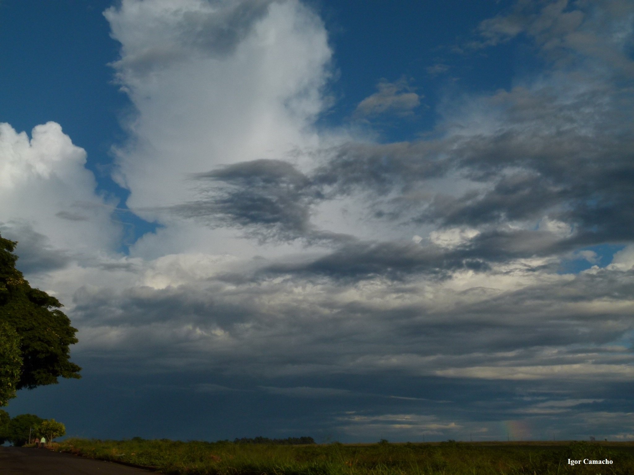
Mín.: 19,5°C
Máx.: 31,9°C
-
Análise 18z com satélite vapor d'agua.
Reparem que bela baixa no pacífico sul e a língua de ar mais seco "puxada" por ela. Outra baixa se forma no atlântico, próximo ao litoral do Espírito Santo.
Baixa muito bonita mesmo Marcelo, essa do Pacífico sul. Olhem essa outra imagem:

-
Dia ensolarado.
Mín.: 17,6°C
Máx.: 31,7°C
Na chuva de ontem a tarde, ocorreram alguns destelhamentos num bairro próximo daqui...
-
Alguém sabe onde foi esse??
Foi esse último de São José do Norte, Paulo.
-
Com o temporal de agora a tarde (42 mm), cheguei a um milagre que era atingir a média mensal (135 mm). Isso aqui em casa, porque na parte da cidade onde trabalho apenas garoou.
Mín.: 17,6°C
Máx.: 33,4°C
-
Ficou legal Ricardo, os caras precisam aproveitar até o domingo que seria folga.
-
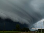
Forte chuva e vendaval provocam estragos em Londrina
Uma chuva forte, seguida de um vendaval que durou menos de cinco minutos, atingiu a cidade de Londrina, na região Norte do Paraná, na tarde deste sábado (28). Com muitos estragos pela cidade, o Corpo de Bombeiros registrou mais de 50 chamados só na zona leste do município, área mais atingida pelo temporal.
Pelos bairros da cidade, árvores quebradas ficaram espalhadas nas ruas. Várias casas tiveram as telhas arrancadas por causa do vento. O mercado municipal também teve parte do telhado prejudicado, e alguns comerciantes ficaram feridos no momento da chuva.
Uma mulher grávida de oitos meses ficou com o tornozelo fraturado após ser atingida por um muro que desabou, mas passa bem.
As imagens dos destelhamentos impressionam!
-
Belíssima formação, ainda mais que não houve relatos de estragos. É nítida a presença de uma super célula!
-
Felicidades Marcelo, parabéns pelo dia!
-
 1
1
-
-
Belas cortinas Ricardo, cenários ainda típicos do verão.
Aqui vão algumas imagens de sábado passado (21). Gerou uma pequena nuvem arco que só trouxe vento.
-
Bom, mas o clarão inicial é produzido pelo choque de fios da rede elétrica não é? Então chegou ao nível do solo sim.
-
Parabéns Alexandre, muitas graças e tudo de bom!
-
1
-
-
Obrigado.. Mas o inseto estava voando por acaso e apareceu do nada, minha tentativa era somente focalizar a joaninha.
-
Mais um dia abaixo dos trinta, muitas nuvens e 1 mm durante a manhã.
Mín.: 20,6°C
Máx.: 27,1°C
-
Beleza Ricardo, a da lua novamente de tirar o fôlego!
Aqui, hoje, após um chuvisqueiro matinal, a natureza nos últimos suspiros da estação recém terminada.
-
Tirando a mínima, ponta-pé inicial de outono com céu encoberto durante o dia. Registrei 4 mm na madruga.
Mín.: 20,2°C
Máx.: 26,6°C
-
Algumas áreas de chuva se formaram na última hora entre o noroeste e o norte do Paraná. Céu com muitas nuvens e 24,5°C agora mas com vento sudeste refrescante.
Mín.: 18,7°C
Máx.: 31,8°C
-
Muito legal!! Funil não vi também.. Mas já bateu uma saudade...! :cry: 8-)
-
Previsão para a temporada de furacões de 2009 no Atlântico Norte, do Accuweather. Diminui o número de sistemas mas alguns podem ter forte impacto!
AccuWeather.com 2009 Hurricane Forecast
"This year takes one major hurricane hitting a highly populated area to have devastating impact." ("Este ano há grande probabilidade de um furacão atingir uma zona densamente povoada e ter impacto devastador.")
"Early indications show a reduction in the overall number of named storms and of major hurricanes in the Atlantic basin compared to last year, but the number of storms should still be near or a little above normal."
Bastardi points to several factors influencing the forecast, including:
1. The weak La Nina in the Pacific Ocean will dissipate. A reverse to a weak El Nino, which is associated with decreased hurricane activity in the Atlantic, is most likely in the middle to latter part of the hurricane season.
2. The expected orientation of high pressure in the eastern Atlantic will produce stronger easterly trade winds across northern Africa than last year. This will result in increased dust and dry air being pushed westward into the Atlantic where many tropical storms originate.
3. Cooler water temperatures in the deep tropical Atlantic, a typical breeding ground for hurricanes, which can reduce hurricane activity and intensity. This may create a season in which storms are reaching a greater intensity farther north and east than last year, leading to less impact in the Caribbean areas hit hard last year.
4. A continuing multi-decadal pattern of higher-than-average water temperatures in the Atlantic, raising the chance of major storms near the East Coast until about 2020.
Based on these and other considerations, Bastardi has made the following specific forecasts for overall numbers and types of storms during the 2009 season as seen on the image above.
Joe Bastardi regularly writes for the AccuWeather.com Professional site, AccuWeather.com Energy Pro, and for private clients.
-
Aqui estrelado e 24,7°C. Quente. Mín. modesta de 19,3°C.
-
Inverno X verão
-
Seja bem vindo.. tenho alguns colegas de trabalho aí e reclamam do calor também. A proximidade com o MS ajuda e muito..mas também.. não posso falar muito, afinal o sul do MS fica ali pertinho...hehe
-
Obrigado pelas dicas Ricardo, essa ficou horrível mesmo, só tirei para retratar o colorido. Se quiser tirar boas fotos não pode ser na correria.
-
Que belas imagens Fabiano, o lugar então, uma maravilha, aparentemente não houve chuva neste sistema não é mesmo?


Vídeos de Tempo Severo no Brasil
in Meteorologia Geral
Posted
Houve realmente uma diminuição significativa neste último verão (seco) aqui na nossa região, mas consegui alguns raros exemplos, os quais postei no BAZ antigo neste ano. Reparei que a ocorrência noturna cresceu um pouco.